Difference between revisions of "Arcadia quadrangle"
m |
Suitupshowup (talk | contribs) (→Linear ridge networks: added images) |
||
| (42 intermediate revisions by 2 users not shown) | |||
| Line 16: | Line 16: | ||
| − | [[File:Arcadia Labeled Base.jpg|thumb|Location of Arcadia quadrangle | + | [[File:Arcadia Labeled Base.jpg|thumb|Location of Arcadia quadrangle.]] |
| − | The Arcadia quadrangle is full of many features that | + | |
| + | The Arcadia quadrangle is full of many features that were discovered with satellites which went in orbit about the planet. Ridge networks, glaciers, dust devil tracks, slope streaks, gullies, latitude dependent mantle, old river channels, and huge troughs are shown and described in this article. We have learned so much about the Red Planet in the nearly half century of study with satellites that went to Mars. | ||
| + | |||
| + | In this article, some of the best pictures from a number of spacecraft will show what the landscape looks like in this region. The origins and significance of all features will be explained as they are currently understood. | ||
| + | |||
The quadrangle contains Alba Patera, the largest volcano (by area) in the solar system, Mareotis Fossae, Tempe Fossae, and Tempe Terra, a highly fractured block of ancient crust about the size of Alaska. | The quadrangle contains Alba Patera, the largest volcano (by area) in the solar system, Mareotis Fossae, Tempe Fossae, and Tempe Terra, a highly fractured block of ancient crust about the size of Alaska. | ||
| − | The Arcadia quadrangle is one of a series of 30 quadrangle maps used by the United States Geological Survey (USGS) . The quadrangle is located in the northern hemisphere of Mars and covers 30° to 65° north latitude and 60° to 120° west longitude (300° to 240° east longitude) | + | The Arcadia quadrangle is one of a series of 30 quadrangle maps used by the United States Geological Survey (USGS). The quadrangle is located in the northern hemisphere of Mars and covers 30° to 65° north latitude and 60° to 120° west longitude (300° to 240° east longitude). The Arcadia quadrangle is also referred to as MC-3 (Mars Chart-3).<ref>Davies, M.E.; Batson, R.M.; Wu, S.S.C. "Geodesy and Cartography" in Kieffer, H.H.; Jakosky, B.M.; Snyder, C.W.; Matthews, M.S., Eds. ''Mars.'' University of Arizona Press: Tucson, 1992.</ref> |
| − | The southern border of the Arcadia quadrangle | + | The southern border of the Arcadia quadrangle spans approximately 3,065 km while and northern border is about 1,500 km wide. The north to south distance is about 2,050 km (slightly less than the length of Greenland).<ref>Distances calculated using NASA World Wind measuring tool. http://worldwind.arc.nasa.gov/.</ref> |
==Origin of Name== | ==Origin of Name== | ||
| − | |||
| + | Arcadia is the name of a classical albedo feature located at 45° north latitude and 260° east longitude on Mars. The feature was named after a mountainous region in southern Greece.<ref>Blunck, J. 1982. Mars and its Satellites. Exposition Press. Smithtown, N.Y.</ref> The name was approved by the International Astronomical Union(IAU) in 1958.<ref>USGS Gazetteer of Planetary Nomenclature. Mars. http://planetarynames.wr.usgs.gov/.</ref> | ||
==Fossa== | ==Fossa== | ||
| − | Large troughs (long narrow depressions) are called fossae in the geographical language used for Mars. This term is derived from Latin; therefore fossa is singular and fossae is plural.<ref>http://www.marsartgallery.com/marsnames.html</ref> Troughs form when the crust is stretched until it breaks. The stretching is from the large weight of | + | |
| + | [[File:ESP 053805 2140troughs.jpg|600pxr|Troughs (Fossae), as seen by HiRISE under HiWish program]] | ||
| + | Troughs (Fossae), as seen by HiRISE under HiWish program | ||
| + | |||
| + | Large troughs (long narrow depressions) are called fossae in the geographical language used for Mars. This term is derived from Latin; therefore fossa is singular and fossae is plural.<ref>http://www.marsartgallery.com/marsnames.html</ref> Troughs form when the crust is stretched until it breaks. The stretching is from the large weight of volcanoes. Fossae/pit craters are common near volcanoes in the Tharsis and Elysium system of volcanoes.<ref>Skinner, J., L. Skinner, and J. Kargel. 2007. Re-assessment of Hydrovolcanism-based Resurfacing within the Galaxias Fossae Region of Mars. Lunar and Planetary Science XXXVIII (2007)</ref> A trough often has two breaks with a middle section moving down, leaving steep cliffs along the sides; such a trough is called a graben.<ref>http://hirise.lpl.arizona.edu/PSP_008641_2105</ref> |Lake George, in northern New York State, is a lake that occupies a graben. Pit craters are often associated with graben. Pit craters do not have rims or ejecta around them, like impact craters do. Studies have found that on Mars a fault may be as deep 5 km, that is the break in the rock goes down 5 km. Moreover, the crack or fault sometimes widens or dilates. This widening causes a void to form with a relatively high volume. When surface material slides into the void, a pit crater or a pit crater chain forms. On Mars, individual pit craters can join to form chains or even to form troughs that are sometimes scalloped.<ref>Wyrick, D., D. Ferrill, D. Sims, and S. Colton. 2003. Distribution, Morphology and Structural Associations of Martian Pit Crater Chains. Lunar and Planetary Science XXXIV (2003)</ref> Other ideas have been suggested for the formation of fossae and pit craters. There is evidence that they are associated with dikes of magma. Magma might move along, under the surface, breaking the rock and more importantly melting ice. The resulting action would cause a crack to form at the surface. Pit craters are not common on Earth.<ref>http://www.msss.com/mars_images/moc/2004/01/29/index.html</ref> | ||
Knowledge of the locations and formation mechanisms of pit craters and fossae is important for the future colonization of Mars because they may be reservoirs of water.<ref>Ferrill, D., D. Wyrick, A. Morris, D. Sims, and N. Franklin. 2004. Dilational fault slip and pit chain formation on Mars 14:10:4-12</ref> Many grabens are found in the Arcadia quadrangle. Pictures below show examples of grabens (Fossa) in Arcadia. | Knowledge of the locations and formation mechanisms of pit craters and fossae is important for the future colonization of Mars because they may be reservoirs of water.<ref>Ferrill, D., D. Wyrick, A. Morris, D. Sims, and N. Franklin. 2004. Dilational fault slip and pit chain formation on Mars 14:10:4-12</ref> Many grabens are found in the Arcadia quadrangle. Pictures below show examples of grabens (Fossa) in Arcadia. | ||
| − | <gallery class="center" widths=" | + | |
| − | + | <gallery class="center" widths="380px" heights="360px"> | |
| − | + | ||
| − | + | ESP 046251 2165graben.jpg|Straight trough is a fossa that would be classified as a graben. Curved channels may have carried lava/water from the fossa. Picture taken with HiRISE under [[HiWish program]]. | |
| − | + | ||
| − | + | ESP 047028 2120troughstreaks.jpg|Troughs with [[dark slope streaks]] | |
| − | ESP 047028 2120troughstreaks.jpg|Troughs with [[dark slope streaks]] | + | |
| − | File:ESP 053754 2125lineofpits.jpg|Line of pits | + | File:ESP 053754 2125lineofpits.jpg|Line of pits Fossae often seem to start with a line of pits. |
| − | File:ESP 053886 2145bigpits.jpg|Pits in shallow trough | + | |
| − | + | File:ESP 053886 2145bigpits.jpg|Pits in shallow trough | |
| − | File:ESP 055521 2105troughscrater.jpg|Troughs (Fossae) | + | |
| − | + | File:ESP 055521 2105troughscrater.jpg|Troughs (Fossae) Trough seems to have cut away part of a crater. | |
| + | |||
| + | |||
| + | Image:Tractus Catena.JPG|Tractus Catena, as seen by HiRISE. Scale bar is 1,000 meters long. | ||
</gallery> | </gallery> | ||
| − | == [[ | + | [[File: ESP 055310 2165troughschannels.jpg|600pxr|Channels coming from a trough]] |
| − | Many | + | Channels coming from a trough |
| + | |||
| + | == Dark slope streaks == | ||
| + | |||
| + | [[File: ESP 056984 2165streaks.jpg|600pxr|Dark slope streaks in crater, as seen by HiRISE under [[HiWish program]]]] | ||
| + | Dark slope streaks in crater, as seen by HiRISE under [[HiWish program]] | ||
| + | |||
| + | Many places on Mars show dark streaks on steep slopes like crater walls. The youngest streaks are dark; they become lighter with age. Often they begin as a small narrow spot then widen and extend downhill for hundreds of meters. They have been seen to travel around obstacles, like boulders.<ref>http://www.space.com/image_of_day_080730.html</ref> | ||
| + | It is most generally accepted that they represent avalanches of dust. The streaks appear in areas covered with dust. When a thin layer of dust is removed, the underlying surface is dark. Much of the Martian surface is covered with dust. Fine dust settles out of the atmosphere covering everything. We know a lot about this dust because the solar panels of the Mars Rovers get covered with dust, thus reducing the electrical energy.<ref>https://www.sciencedaily.com/releases/2009/02/090217101110.htm|access-date=2017-06-01|date=2009-02-19|title=Mars Spirit Rover Gets Energy Boost From Cleaner Solar Panels|work=[[Science Daily]]</ref> Dust storms are frequent, especially when the spring season begins in the southern hemisphere. At that time, Mars is 40% closer to the sun. The orbit of Mars is much more elliptical then the Earth's. That is the difference between the farthest point from the sun and the closest point to the sun is very great for Mars, but very little for the Earth. Also, every few years, the entire planet is engulfed in a global dust storm. When NASA's [[Mariner 9]] craft arrived there, nothing could be seen through the storm.<ref>|isbn = 0-517-00192-6|title = Atlas of the Solar System|last1 = Moore|first1 = Patrick|</ref> <ref>Hugh H. Kieffer|title=Mars|url=https://books.google.com/books?id=NoDvAAAAMAAJ|accessdate=7 March 2011|year=1992|publisher=University of Arizona Press|</ref> Other global dust storms have also been observed, since that time. | ||
| + | Research, published in January 2012 in Icarus, found that dark streaks were initiated by airblasts from meteorites traveling at supersonic speeds. The team of scientists was led by Kaylan Burleigh, an undergraduate at the University of Arizona. After counting some 65,000 dark streaks around the impact site of a group of 5 new craters, the team saw clear patterns. The number of streaks was greatest closer to the impact site. So, the impact somehow probably caused the streaks. Also, the distribution of the streaks formed a pattern with two wings extending from the impact site. The curved wings resembled scimitars, curved knives. This pattern suggests that an interaction of airblasts from the group of meteorites shook dust loose enough to start dust avalanches that formed the many dark streaks. At first it was thought that the shaking of the ground from the impact caused the dust avalanches, but if that was the case the dark streaks would have been arranged symmetrically around the impacts, rather than being concentrated into curved shapes.<ref>Burleigh | first1 = Kaylan J. | last2 = Melosh | first2 = Henry J. | last3 = Tornabene | first3 = Livio L. | last4 = Ivanov | first4 = Boris | last5 = McEwen | first5 = Alfred S. | last6 = Daubar | first6 = Ingrid J. | year = 2012 | title = Impact air blast triggers dust avalanches on Mars | url = | journal = Icarus | volume = 217 | issue = 1| page = 194 | doi = 10.1016/j.icarus.2011.10.026 | </ref> <ref>http://redplanet.asu.edu/</ref> Dark streaks can be seen in the image below that was taken by HiRISE. | ||
| + | |||
| + | |||
| + | <gallery class="center" widths="380px" heights="360px"> | ||
| − | |||
| − | |||
| − | |||
| − | + | 52593 2140streaks.jpg|Dark slope streaks | |
| − | |||
| − | |||
| − | |||
| − | |||
| − | |||
| − | |||
| − | |||
| − | |||
</gallery> | </gallery> | ||
==[[Martian gullies]]== | ==[[Martian gullies]]== | ||
| − | Some excellent examples of Martian gullies are found | + | Some excellent examples of Martian gullies are found in the arcadia quadrangle. Gullies occur on steep slopes, especially on the walls of craters. Gullies are believed to be relatively young because they have few, if any, craters. Moreover, they lie on top of sand dunes which themselves are considered to be quite young. Usually, each gully has an alcove, channel, and apron.<ref>Edgett |first1= K. |last2= Malin |first2= M. C. |last3= Williams |first3= R. M. E. |last4= Davis |first4= S. D. |date= 2003 |title= Polar-and middle-latitude martian gullies: A view from MGS MOC after 2 Mars years in the mapping orbit |journal= Lunar Planet. Sci. |volume=34 |at=p. 1038, Abstract 1038 | url=http://www.lpi.usra.edu/meetings/lpsc2003/pdf/1038.pdf |</ref> |
| − | Gullies were once thought to be caused by recent flowing water. However, with further extensive observations with HiRISE, it was found that many are forming/changing today, even though liquid water cannot exist under current Martian conditions. Faced with these new observations, scientists came up with other ideas to explain them. The consensus seems to be that although water may have helped form them in the past, today they are being produced by chunks of dry ice moving down steep slopes. <ref>Harrington |first=J.D. |last2=Webster |first2=Guy |title=RELEASE 14-191 – NASA Spacecraft Observes Further Evidence of Dry Ice Gullies on Mars |url=http://www.nasa.gov/press/2014/july/nasa-spacecraft-observes-further-evidence-of-dry-ice-gullies-on-mars |date=July 10, 2014 |work=NASA</ref> <ref>CNRS. "Gullies on Mars sculpted by dry ice rather than liquid water." ScienceDaily. ScienceDaily, 22 December 2015. www.sciencedaily.com/releases/2015/12/151222082255.htm </ref> <ref>http://www.skyandtelescope.com/astronomy-news/martian-gullies-triggered-by-exploding-dry-ice-122320158</ref> Repeated observations of gullies that were changing today revealed that they changing in the season when dry ice would | + | Gullies were once thought to be caused by recent flowing water. However, with further extensive observations with HiRISE, it was found that many are forming/changing today, even though liquid water cannot exist under current Martian conditions. Faced with these new observations, scientists came up with other ideas to explain them. The consensus seems to be that although water may have helped form them in the past, today they are being produced by chunks of dry ice moving down steep slopes. <ref>Harrington |first=J.D. |last2=Webster |first2=Guy |title=RELEASE 14-191 – NASA Spacecraft Observes Further Evidence of Dry Ice Gullies on Mars |url=http://www.nasa.gov/press/2014/july/nasa-spacecraft-observes-further-evidence-of-dry-ice-gullies-on-mars |date=July 10, 2014 |work=NASA</ref> <ref>CNRS. "Gullies on Mars sculpted by dry ice rather than liquid water." ScienceDaily. ScienceDaily, 22 December 2015. www.sciencedaily.com/releases/2015/12/151222082255.htm </ref> <ref>http://www.skyandtelescope.com/astronomy-news/martian-gullies-triggered-by-exploding-dry-ice-122320158</ref> Repeated observations of gullies that were changing today revealed that they changing in the season when dry ice would most likely be breaking up and moving down slopes. The movement would be aided by carbon dioxide lifting/lubricating the chunks of dry ice |
| + | |||
| + | |||
| + | <gallery class="center" widths="380px" heights="360px"> | ||
| + | |||
| + | ESP 044707 2285gullies.jpg|Gullies along mesa wall in North Tempe Terra, as seen by HiRISE under HiWish program | ||
| − | + | Image:25771gullybenches.jpg|Terraces along a gully channel. The terraces were created when a new channel cut through the old surface. This means that the gully was not made in just a single event. | |
| − | + | ||
| − | Image:25771gullybenches.jpg| | + | Image:ESP_028290_2285gullies.jpg|Gullies in a crater. Some seem to be young, others are well developed. Picture was taken by HiRISE under the [[HiWish program]]. |
| − | Image:ESP_028290_2285gullies.jpg|Gullies in a crater. Some seem to be young, others are well developed. Picture was taken by HiRISE under the HiWish program | + | |
| − | + | ||
| − | + | ESP 044852 2285gullies1.jpg|Gullies on wall of mesa | |
| − | |||
| − | |||
| − | |||
| − | |||
| − | ESP 044852 2285gullies1.jpg|Gullies on wall of mesa | ||
</gallery> | </gallery> | ||
| − | <gallery class="center" widths=" | + | <gallery class="center" widths="380px" heights="360px"> |
| − | ESP 052737 2305gullies.jpg|Wide view of gullies | + | ESP 052737 2305gullies.jpg|Wide view of gullies |
| − | + | ||
| − | + | 52737 2305gulliesstreamlined.jpg|Close view of gullies Streamlined features are visible in gully channels. | |
| − | 52737 2305gulliesstreamlined.jpg|Close view of gullies | ||
</gallery> | </gallery> | ||
| + | |||
| + | [[File: 52737 2305gulliespolygons.jpg|600pxr|Close view of gully alcoves Polygons are visible.]] | ||
| + | Close view of gully alcoves Polygons are visible. | ||
==Latitude dependent mantle== | ==Latitude dependent mantle== | ||
Much of the surface of Mars is covered by a thick smooth mantle that is thought to be a mixture of ice and dust. This ice-rich mantle, a few yards thick, makes the surface look very smooth. Because there are few craters on this mantle, the mantle is relatively young. Mantle falls from the air during certain climates. | Much of the surface of Mars is covered by a thick smooth mantle that is thought to be a mixture of ice and dust. This ice-rich mantle, a few yards thick, makes the surface look very smooth. Because there are few craters on this mantle, the mantle is relatively young. Mantle falls from the air during certain climates. | ||
| − | Changes in Mars's orbit and tilt cause significant changes in the distribution of water ice from Polar Regions down to latitudes equivalent to Texas. During certain climate periods, water vapor leaves polar ice and enters the atmosphere. The water returns to the ground at lower latitudes as deposits of frost or snow mixed generously with dust. The atmosphere of Mars contains a great deal of fine dust particles. Water vapor condenses on the particles, and then they fall down to the ground due to the additional weight of the water coating. When ice at the top of the mantling layer goes back into the atmosphere, it leaves behind dust, which insulates the remaining ice. | + | Changes in Mars's orbit and tilt cause significant changes in the distribution of water ice from Polar Regions down to latitudes equivalent to Texas. During certain climate periods, water vapor leaves polar ice and enters the atmosphere. The water returns to the ground at lower latitudes as deposits of frost or snow mixed generously with dust. The atmosphere of Mars contains a great deal of fine dust particles. Water vapor condenses or freezes on the particles, and then they fall down to the ground due to the additional weight of the water/ice coating. When ice at the top of the mantling layer goes back into the atmosphere, it leaves behind dust, which insulates the remaining ice. |
| − | <gallery class="center" widths=" | + | <gallery class="center" widths="380px" heights="360px"> |
| − | + | ||
| − | + | 50562mantle.jpg|Close views of mantle, as seen by HiRISE under [[HiWish program]] | |
| − | 50562mantle.jpg|Close views of mantle, as seen by HiRISE under HiWish program | ||
| − | |||
</gallery> | </gallery> | ||
| − | <gallery class="center" widths=" | + | <gallery class="center" widths="380px" heights="360px"> |
| − | + | ||
50456 2250mantle2.jpg|Close view of mantle, as seen by HiRISE under HiWish program | 50456 2250mantle2.jpg|Close view of mantle, as seen by HiRISE under HiWish program | ||
| − | + | File:54742 2235mantle2.jpg|Close view of mantle | |
| − | |||
| − | |||
| − | |||
| − | File:54742 2235mantle2.jpg|Close view of mantle | ||
| − | |||
</gallery> | </gallery> | ||
| Line 118: | Line 125: | ||
==Glacial features== | ==Glacial features== | ||
| − | Glaciers, loosely defined as patches of currently or recently flowing ice, are thought to be present across large areas of the modern Martian surface, and | + | Glaciers, loosely defined as patches of currently or recently flowing ice, are thought to be present across large areas of the modern Martian surface, and would have been more widely distributed at times in the past.<ref>Carr, M."The Surface of Mars" Series: Cambridge Planetary Science (No. 6) ISBN|978-0-511-26688-1 Michael H. Carr, United States Geological Survey, Menlo Park</ref> <ref> Hugh H. Kieffer (1992). Mars. University of Arizona Press. ISBN 978-0-8165-1257-7. </ref> Lobate convex features on the surface known as viscous flow features and lobate debris aprons regarded as true glaciers.<ref>Milliken | first1 = R. E. | last2 = Mustard | first2 = J. F. | last3 = Goldsby | first3 = D. L. | year = 2003 | title = Viscous flow features on the surface of Mars: Observations from high-resolution Mars Orbiter Camera (MOC) images | url = https://semanticscholar.org/paper/a822f14644d2294b948e101be2f294ac33b57ec3| journal = Journal of Geophysical Research | volume = 108 | issue = E6| page = 5057 |</ref> <ref>Squyres | first1 = S.W. | last2 = Carr | first2 = M.H. | year = 1986 | title = Geomorphic evidence for the distribution of ground ice on Mars | url = | journal = Science | volume = 213 | issue = 4735| pages = 249–253 | doi = 10.1126/science.231.4735.249 | pmid = 17769645 | </ref> <ref>Head | first1 = J.W. | last2 = Marchant | first2 = D.R. | last3 = Dickson | first3 = J.L. | last4 = Kress | first4 = A.M. | year = 2010 | title = Criteria for the recognition of debris-covered glacier and valley glacier landsystem deposits | url = | journal = Earth Planet. Sci. Lett. | volume = 294 | issue = | pages = 306–320 | doi=10.1016/j.epsl.2009.06.041 | </ref> <ref>Holt | first1 = J.W. |display-authors=et al | year = 2008 | title = Radar sounding evidence for buried glaciers in the southern mid-latitudes of Mars | url = | journal = Science | volume = 322 | issue = 5905| pages = 1235–1238 | doi=10.1126/science.1164246 | pmid=19023078| </ref> <ref>Morgan | first1 = G.A. | last2 = Head | first2 = J.W. | last3 = Marchant | first3 = D.R. | year = 2009 | title = Lineated valley fill (LVF) and lobate debris aprons (LDA) in the Deuteronilus Mensae northern dichotomy boundary region, Mars: Constraints on the extent, age and episodicity of Amazonian glacial events | url = | journal = Icarus | volume = 202 | issue = 1| pages = 22–38 | doi=10.1016/j.icarus.2009.02.017 |</ref> <ref >Plaut | first1 = J.J. | last2 = Safaeinili | first2 = A. | last3 = Holt | first3 = J.W. | last4 = Phillips | first4 = R.J. | last5 = Head | first5 = J.W. | last6 = Sue | first6 = R. | last7 = Putzig | first7 = A. | year = 2009 | title = Frigeri Radar evidence for ice in lobate debris aprons in the mid-northern latitudes of Mars | url = https://semanticscholar.org/paper/f6b94761e6a276ce6894374ae9bea88fdc3e5e19| journal = Geophys. Res. Lett. | volume = 36 | issue = 2| page = L02203 | doi=10.1029/2008gl036379| </ref> <ref>Baker | first1 = D.M.H. | last2 = Head | first2 = J.W. | last3 = Marchant | first3 = D.R. | year = 2010 | title = Flow patterns of lobate debris aprons and lineated valley fill north of Ismeniae Fossae, Mars: Evidence for extensive mid-latitude glaciation in the Late Amazonian | url = | journal = Icarus | volume = 207 | issue = 1| pages = 186–209 | </ref> <ref>Arfstrom | first1 = J. | year = 2005 | title = Terrestrial analogs and interrelationships | url = | journal = Icarus | volume = 174 | issue = 2| pages = 321–335 | doi=10.1016/j.icarus.2004.05.026 | </ref> |
| + | |||
| + | <gallery class="center" widths="380px" heights="360px"> | ||
| − | + | ESP 050483 2240glacier.jpg|Glacier, as seen by HiRISE under [[HiWish program]] | |
| − | |||
| − | + | Image:23503esker.jpg|Eskers form when a stream runs under a glacier. | |
| − | Image:23503esker.jpg| | ||
| − | File:ESP 054900 2305lda.jpg|Lobate debris apron (LDA) around a mound | + | File:ESP 054900 2305lda.jpg|Lobate debris apron (LDA) around a mound Lobate debris aprons are considered to be glaciers covered with a layer of debris. |
</gallery> | </gallery> | ||
==Channels== | ==Channels== | ||
| + | |||
| + | [[File:ESP_025336channels.jpg|600pxr|Channels, as seen by HiRISE under HiWish program. Stream appears to have eroded through a hill.]] | ||
| + | Channels, as seen by HiRISE under HiWish program. Stream appears to have eroded through a hill. | ||
| + | |||
Many places on Mars show channels of different sizes. Many of these channels probably carried water, at least for a time. The climate of Mars may have been such in the past that water ran on its surface. | Many places on Mars show channels of different sizes. Many of these channels probably carried water, at least for a time. The climate of Mars may have been such in the past that water ran on its surface. | ||
| − | |||
| − | |||
| − | |||
| − | |||
| − | |||
| − | |||
| − | + | <gallery class="center" widths="380px" heights="360px"> | |
| − | + | ||
| − | + | Wikiperepelkinmantle.jpg|Channels and mantle, as seen by CTX camera (on Mars Reconnaissance Orbiter). Channels are exposed where the mantle has disappeared. Mantle falls from the sky during certain climate periods. | |
| + | |||
| + | |||
| + | ESP 045895 2225channelstroughs.jpg|Channel that went across trough | ||
| − | File:ESP 054598 2250channels.jpg|Channels | + | File:ESP 054598 2250channels.jpg|Channels |
File:ESP 055508 2245channels.jpg|Channels, as seen by HiRISE under HiWish program | File:ESP 055508 2245channels.jpg|Channels, as seen by HiRISE under HiWish program | ||
| − | File:ESP 055297 2260channels.jpg|Channels | + | |
| + | File:ESP 055297 2260channels.jpg|Channels The channel in places seems to disappear and then reappear. In those places water was probably flowing underground. | ||
| + | |||
| + | ESP 052686 2120layersridges.jpg|Crater with channels, as seen by HiRISE under [[HiWish program]] This crater once contained a lake. | ||
| + | File:C hannels 64528 2255.jpg|Group of channels, this image was named HiRISE picture of he day for October 27, 2021. | ||
| + | |||
| + | Tempe Fossae Sinuous Channel.JPG|Sinuous Channel in Tempe Fossae, as seen by HiRISE. | ||
</gallery> | </gallery> | ||
| + | |||
| + | [[File: ESP 045868 2245channel.jpg|600pxr|Channel, as seen by HiRISE under [[HiWish program]] Arrow points to a crater that was probably eroded by flowing water.]] | ||
| + | Channel, as seen by HiRISE Arrow points to a crater that was probably eroded by flowing water. | ||
==Dipping layers== | ==Dipping layers== | ||
| − | |||
| − | + | [[File: 46329 2280pyramids.jpg|600pxr|Close view of slopes that contain dipping layered features, as seen by HiRISE under [[HiWish program]]]] | |
| − | + | Close view of slopes that contain dipping layered features, as seen by HiRISE under [[HiWish program]] | |
| − | + | ||
| − | 46329 2280pyramidsbottom.jpg|Close view of slopes that contain | + | |
| + | |||
| + | Dipping groups of layers along slopes, especially along crater walls are believed to be the remains of a once widespread material that has mostly been eroded away.<ref>Carr | first1 = M | year = 2001 | title = Mars Global Surveyor observations of martian fretted terrain | url = | journal = J. Geophys. Res. | volume = 106 | issue = | pages = 23571–23593 | </ref> | ||
| + | |||
| + | <gallery class="center" widths="380px" heights="360px"> | ||
| + | |||
| + | |||
| + | 46329 2280pyramidsbottom.jpg|Close view of slopes that contain groups of dipping layers | ||
| + | |||
| + | File:55546 2290dipping.jpg|Mantle and mantle layers To the left part of the picture mantle layers seem to have formed dipping layers. | ||
| + | |||
</gallery> | </gallery> | ||
==Linear ridge networks== | ==Linear ridge networks== | ||
| − | + | ||
| + | [[File: ESP 047054 2160ridges.jpg|600pxr|Wide view of ridge network]] | ||
| + | Wide view of ridge network | ||
| + | |||
| + | Linear ridge networks are found in various places on Mars in and around craters.<ref>Head, J., J. Mustard. 2006. Breccia dikes and crater-related faults in impact craters on Mars: Erosion and exposure on the floor of a crater 75 km in diameter at the dichotomy boundary, Meteorit. Planet Science: 41, 1675-1690.</ref> These features have also been called "polygonal ridge networks," "boxwork ridges", and "reticulate ridges."<ref>Moore, J., D. Wilhelms. 2001. Hellas as a possible site of ancient ice-covered lakes on Mars. Icarus: 154, 258-276.</ref> Ridges often appear as mostly straight segments that intersect in a lattice-like manner. They are hundreds of meters long, tens of meters high, and several meters wide. One popular idea for their formation is that impacts created fractures in the surface, these fractures later acted as channels for fluids. Fluids became hard. With the passage of time, surrounding material was eroded away, thereby leaving hard ridges behind. However, we do not yet agree on the exact cause. | ||
| − | <gallery class="center" widths=" | + | <gallery class="center" widths="380px" heights="360px"> |
| + | |||
| + | 47054 2160largeridges.jpg|Close view of ridge networks Arrow points to small, straight ridge. | ||
| + | 47054 2160largeridgeschanging.jpg|Close view of small and large ridges | ||
| + | |||
| + | </gallery> | ||
| + | |||
| + | <gallery class="center" widths="380px" heights="360px"> | ||
ESP 047054 2160ridges.jpg|Wide view of ridge network, as seen by HiRISE under HiWish program | ESP 047054 2160ridges.jpg|Wide view of ridge network, as seen by HiRISE under HiWish program | ||
47054 2160largeridges.jpg|Close view of ridge networks, as seen by HiRISE under HiWish program Arrow points to small, straight ridge. | 47054 2160largeridges.jpg|Close view of ridge networks, as seen by HiRISE under HiWish program Arrow points to small, straight ridge. | ||
47054 2160largeridgeschanging.jpg|Close view of small and large ridges, as seen by HiRISE under HiWish program | 47054 2160largeridgeschanging.jpg|Close view of small and large ridges, as seen by HiRISE under HiWish program | ||
47054 2160smallridges.jpg|Close view of small and large ridges, as seen by HiRISE under HiWish program | 47054 2160smallridges.jpg|Close view of small and large ridges, as seen by HiRISE under HiWish program | ||
| − | + | ||
| + | File:Ridges ESP 074906 2160.jpg|Ridges, this pictures was named HiRISE picture of the day on March 29, 2024. | ||
| + | File:Ridges in ESP 074906 2160.jpg|Ridges, this pictures was named HiRISE picture of the day on March 29, 2024. | ||
| + | File:74906 2160wideridgescratercropped.jpg|Ridges, this picture was named HiRISE picture of the day on March 29, 2024. A channel that has transverse aeolian ridges on the foor is also visible. | ||
| + | |||
| + | File:ESP 074906 2160-2ridgesclose.jpg|Close view of ridges This picture was named HiRISE picture of the day on March 29, 2024. | ||
==Layers== | ==Layers== | ||
| + | |||
| + | [[File: 43824 2160layers.jpg|600pxr|Layers Location is Tempe Terra]] | ||
| + | Layers Location is Tempe Terra | ||
| + | |||
Many places on Mars show rocks arranged in layers. Rock can form layers in a variety of ways. Volcanoes, wind, or water can produce layers.<ref>http://hirise.lpl.arizona.edu?PSP_008437_1750 |title=HiRISE | High Resolution Imaging Science Experiment |publisher=Hirise.lpl.arizona.edu?psp_008437_1750 |</ref> | Many places on Mars show rocks arranged in layers. Rock can form layers in a variety of ways. Volcanoes, wind, or water can produce layers.<ref>http://hirise.lpl.arizona.edu?PSP_008437_1750 |title=HiRISE | High Resolution Imaging Science Experiment |publisher=Hirise.lpl.arizona.edu?psp_008437_1750 |</ref> | ||
A detailed discussion of layering with many Martian examples can be found in Sedimentary Geology of Mars.<ref>Grotzinger, J. and R. Milliken (eds.). 2012. Sedimentary Geology of Mars. SEPM.</ref> | A detailed discussion of layering with many Martian examples can be found in Sedimentary Geology of Mars.<ref>Grotzinger, J. and R. Milliken (eds.). 2012. Sedimentary Geology of Mars. SEPM.</ref> | ||
| − | |||
| − | |||
| − | |||
| − | |||
| − | |||
<gallery class="center" widths="190px" heights="180px" > | <gallery class="center" widths="190px" heights="180px" > | ||
| − | File:ESP 054847 2110crater.jpg|Wide view of crater with layers near the top | + | File:ESP 054847 2110crater.jpg|Wide view of crater with layers near the top |
| − | + | ||
| − | + | File:55652 2245layersboulders.jpg|Close view of layers and boulders in the wall of a trough | |
| − | File:55652 2245layersboulders.jpg|Close view of layers and boulders in the wall of a trough | + | |
| − | File:55652 2245layersclose.jpg|Close, color view of layers in a trough | + | File:55652 2245layersclose.jpg|Close, color view of layers in a trough |
</gallery> | </gallery> | ||
| − | <gallery class="center" widths=" | + | <gallery class="center" widths="380px" heights="360px"> |
| − | + | ||
| − | 52689 2120layers.jpg|Layers on crater wall | + | 52689 2120layers.jpg|Layers on crater wall |
| − | |||
| − | |||
| − | |||
</gallery> | </gallery> | ||
| + | |||
| + | [[File:54847 2110craterlayers.jpg|600pxr|Close, color view of layers near top of crater, as seen by HiRISE under [[HiWish program]]]] | ||
| + | Close, color view of layers near top of crater, as seen by HiRISE under[[ HiWish program]] | ||
== Other Features in the Arcadia quadrangle == | == Other Features in the Arcadia quadrangle == | ||
| − | <gallery class="center" widths=" | + | <gallery class="center" widths="380px" heights="360px"> |
| − | + | File:ESP 055600 2240lavaflow.jpg|Lava flows | |
| − | + | ||
| − | File:ESP 055389 2280doublecrater.jpg|Double crater, as seen by HiRISE under [[HiWish program]] | + | File:ESP 055389 2280doublecrater.jpg|Double crater, as seen by HiRISE under [[HiWish program]] An asteroid probably broke in two right before it impacted the surface. |
| − | + | ||
| − | + | File:ESP 056628 2150hollows.jpg|Wide view of craters, layers, streaks, hollows | |
| − | + | ||
| − | + | File:56628 2150hollows.jpg|Close view of hollows | |
| − | |||
| − | |||
| − | File:ESP 056628 2150hollows.jpg|Wide view of craters, layers, streaks, hollows | ||
| − | File:56628 2150hollows.jpg|Close view of hollows | ||
| + | 52689 2120ridges.jpg|Ridges on crater floor | ||
| + | File:Ring mold crater ESP 076674 2160.jpg|Ring mold crater This image was named HiRISE picture of the day. Ring mold craters are caused by a rebound of an ice layer after being struck by an impacting body. | ||
</gallery> | </gallery> | ||
| − | |||
== See also == | == See also == | ||
Latest revision as of 07:26, 30 March 2024
| MC-03 | Arcadia | 30–65° N | 60–120° W | Quadrangles | Atlas |


The Arcadia quadrangle is full of many features that were discovered with satellites which went in orbit about the planet. Ridge networks, glaciers, dust devil tracks, slope streaks, gullies, latitude dependent mantle, old river channels, and huge troughs are shown and described in this article. We have learned so much about the Red Planet in the nearly half century of study with satellites that went to Mars.
In this article, some of the best pictures from a number of spacecraft will show what the landscape looks like in this region. The origins and significance of all features will be explained as they are currently understood.
The quadrangle contains Alba Patera, the largest volcano (by area) in the solar system, Mareotis Fossae, Tempe Fossae, and Tempe Terra, a highly fractured block of ancient crust about the size of Alaska. The Arcadia quadrangle is one of a series of 30 quadrangle maps used by the United States Geological Survey (USGS). The quadrangle is located in the northern hemisphere of Mars and covers 30° to 65° north latitude and 60° to 120° west longitude (300° to 240° east longitude). The Arcadia quadrangle is also referred to as MC-3 (Mars Chart-3).[1] The southern border of the Arcadia quadrangle spans approximately 3,065 km while and northern border is about 1,500 km wide. The north to south distance is about 2,050 km (slightly less than the length of Greenland).[2]
Contents
Origin of Name
Arcadia is the name of a classical albedo feature located at 45° north latitude and 260° east longitude on Mars. The feature was named after a mountainous region in southern Greece.[3] The name was approved by the International Astronomical Union(IAU) in 1958.[4]
Fossa

Troughs (Fossae), as seen by HiRISE under HiWish program
Large troughs (long narrow depressions) are called fossae in the geographical language used for Mars. This term is derived from Latin; therefore fossa is singular and fossae is plural.[5] Troughs form when the crust is stretched until it breaks. The stretching is from the large weight of volcanoes. Fossae/pit craters are common near volcanoes in the Tharsis and Elysium system of volcanoes.[6] A trough often has two breaks with a middle section moving down, leaving steep cliffs along the sides; such a trough is called a graben.[7] |Lake George, in northern New York State, is a lake that occupies a graben. Pit craters are often associated with graben. Pit craters do not have rims or ejecta around them, like impact craters do. Studies have found that on Mars a fault may be as deep 5 km, that is the break in the rock goes down 5 km. Moreover, the crack or fault sometimes widens or dilates. This widening causes a void to form with a relatively high volume. When surface material slides into the void, a pit crater or a pit crater chain forms. On Mars, individual pit craters can join to form chains or even to form troughs that are sometimes scalloped.[8] Other ideas have been suggested for the formation of fossae and pit craters. There is evidence that they are associated with dikes of magma. Magma might move along, under the surface, breaking the rock and more importantly melting ice. The resulting action would cause a crack to form at the surface. Pit craters are not common on Earth.[9] Knowledge of the locations and formation mechanisms of pit craters and fossae is important for the future colonization of Mars because they may be reservoirs of water.[10] Many grabens are found in the Arcadia quadrangle. Pictures below show examples of grabens (Fossa) in Arcadia.

Straight trough is a fossa that would be classified as a graben. Curved channels may have carried lava/water from the fossa. Picture taken with HiRISE under HiWish program.

Troughs with dark slope streaks

Line of pits Fossae often seem to start with a line of pits.
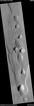
Pits in shallow trough
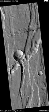
Troughs (Fossae) Trough seems to have cut away part of a crater.
Tractus Catena, as seen by HiRISE. Scale bar is 1,000 meters long.


Channels coming from a trough
Dark slope streaks

Dark slope streaks in crater, as seen by HiRISE under HiWish program
Many places on Mars show dark streaks on steep slopes like crater walls. The youngest streaks are dark; they become lighter with age. Often they begin as a small narrow spot then widen and extend downhill for hundreds of meters. They have been seen to travel around obstacles, like boulders.[11] It is most generally accepted that they represent avalanches of dust. The streaks appear in areas covered with dust. When a thin layer of dust is removed, the underlying surface is dark. Much of the Martian surface is covered with dust. Fine dust settles out of the atmosphere covering everything. We know a lot about this dust because the solar panels of the Mars Rovers get covered with dust, thus reducing the electrical energy.[12] Dust storms are frequent, especially when the spring season begins in the southern hemisphere. At that time, Mars is 40% closer to the sun. The orbit of Mars is much more elliptical then the Earth's. That is the difference between the farthest point from the sun and the closest point to the sun is very great for Mars, but very little for the Earth. Also, every few years, the entire planet is engulfed in a global dust storm. When NASA's Mariner 9 craft arrived there, nothing could be seen through the storm.[13] [14] Other global dust storms have also been observed, since that time. Research, published in January 2012 in Icarus, found that dark streaks were initiated by airblasts from meteorites traveling at supersonic speeds. The team of scientists was led by Kaylan Burleigh, an undergraduate at the University of Arizona. After counting some 65,000 dark streaks around the impact site of a group of 5 new craters, the team saw clear patterns. The number of streaks was greatest closer to the impact site. So, the impact somehow probably caused the streaks. Also, the distribution of the streaks formed a pattern with two wings extending from the impact site. The curved wings resembled scimitars, curved knives. This pattern suggests that an interaction of airblasts from the group of meteorites shook dust loose enough to start dust avalanches that formed the many dark streaks. At first it was thought that the shaking of the ground from the impact caused the dust avalanches, but if that was the case the dark streaks would have been arranged symmetrically around the impacts, rather than being concentrated into curved shapes.[15] [16] Dark streaks can be seen in the image below that was taken by HiRISE.
Dark slope streaks

Martian gullies
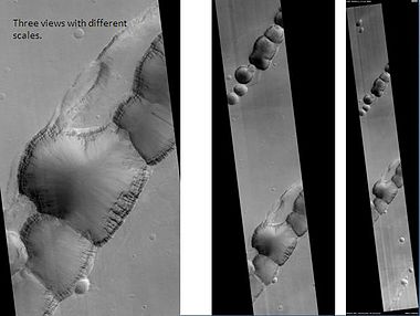
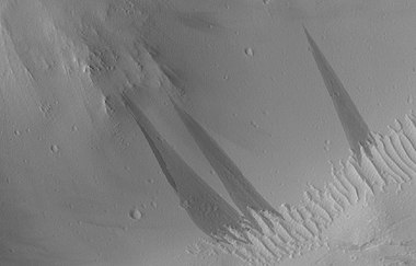
Some excellent examples of Martian gullies are found in the arcadia quadrangle. Gullies occur on steep slopes, especially on the walls of craters. Gullies are believed to be relatively young because they have few, if any, craters. Moreover, they lie on top of sand dunes which themselves are considered to be quite young. Usually, each gully has an alcove, channel, and apron.[17] Gullies were once thought to be caused by recent flowing water. However, with further extensive observations with HiRISE, it was found that many are forming/changing today, even though liquid water cannot exist under current Martian conditions. Faced with these new observations, scientists came up with other ideas to explain them. The consensus seems to be that although water may have helped form them in the past, today they are being produced by chunks of dry ice moving down steep slopes. [18] [19] [20] Repeated observations of gullies that were changing today revealed that they changing in the season when dry ice would most likely be breaking up and moving down slopes. The movement would be aided by carbon dioxide lifting/lubricating the chunks of dry ice
Gullies along mesa wall in North Tempe Terra, as seen by HiRISE under HiWish program
Terraces along a gully channel. The terraces were created when a new channel cut through the old surface. This means that the gully was not made in just a single event.
Gullies in a crater. Some seem to be young, others are well developed. Picture was taken by HiRISE under the HiWish program.
Gullies on wall of mesa


Wide view of gullies

Close view of gullies Streamlined features are visible in gully channels.


Close view of gully alcoves Polygons are visible.
Latitude dependent mantle
Much of the surface of Mars is covered by a thick smooth mantle that is thought to be a mixture of ice and dust. This ice-rich mantle, a few yards thick, makes the surface look very smooth. Because there are few craters on this mantle, the mantle is relatively young. Mantle falls from the air during certain climates. Changes in Mars's orbit and tilt cause significant changes in the distribution of water ice from Polar Regions down to latitudes equivalent to Texas. During certain climate periods, water vapor leaves polar ice and enters the atmosphere. The water returns to the ground at lower latitudes as deposits of frost or snow mixed generously with dust. The atmosphere of Mars contains a great deal of fine dust particles. Water vapor condenses or freezes on the particles, and then they fall down to the ground due to the additional weight of the water/ice coating. When ice at the top of the mantling layer goes back into the atmosphere, it leaves behind dust, which insulates the remaining ice.

Close views of mantle, as seen by HiRISE under HiWish program


Close view of mantle, as seen by HiRISE under HiWish program

Close view of mantle


Glacial features
Glaciers, loosely defined as patches of currently or recently flowing ice, are thought to be present across large areas of the modern Martian surface, and would have been more widely distributed at times in the past.[21] [22] Lobate convex features on the surface known as viscous flow features and lobate debris aprons regarded as true glaciers.[23] [24] [25] [26] [27] [28] [29] [30]

Glacier, as seen by HiRISE under HiWish program

Eskers form when a stream runs under a glacier.

Lobate debris apron (LDA) around a mound Lobate debris aprons are considered to be glaciers covered with a layer of debris.


Channels

Channels, as seen by HiRISE under HiWish program. Stream appears to have eroded through a hill.
Many places on Mars show channels of different sizes. Many of these channels probably carried water, at least for a time. The climate of Mars may have been such in the past that water ran on its surface.

Channels and mantle, as seen by CTX camera (on Mars Reconnaissance Orbiter). Channels are exposed where the mantle has disappeared. Mantle falls from the sky during certain climate periods.

Channel that went across trough

Channels

Channels, as seen by HiRISE under HiWish program

Channels The channel in places seems to disappear and then reappear. In those places water was probably flowing underground.

Crater with channels, as seen by HiRISE under HiWish program This crater once contained a lake.

Group of channels, this image was named HiRISE picture of he day for October 27, 2021.

Sinuous Channel in Tempe Fossae, as seen by HiRISE.


Channel, as seen by HiRISE Arrow points to a crater that was probably eroded by flowing water.
Dipping layers

Close view of slopes that contain dipping layered features, as seen by HiRISE under HiWish program
Dipping groups of layers along slopes, especially along crater walls are believed to be the remains of a once widespread material that has mostly been eroded away.[31]

Close view of slopes that contain groups of dipping layers

Mantle and mantle layers To the left part of the picture mantle layers seem to have formed dipping layers.


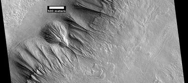
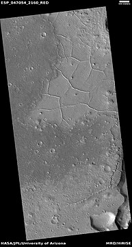
Linear ridge networks

Wide view of ridge network
Linear ridge networks are found in various places on Mars in and around craters.[32] These features have also been called "polygonal ridge networks," "boxwork ridges", and "reticulate ridges."[33] Ridges often appear as mostly straight segments that intersect in a lattice-like manner. They are hundreds of meters long, tens of meters high, and several meters wide. One popular idea for their formation is that impacts created fractures in the surface, these fractures later acted as channels for fluids. Fluids became hard. With the passage of time, surrounding material was eroded away, thereby leaving hard ridges behind. However, we do not yet agree on the exact cause.

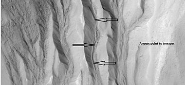
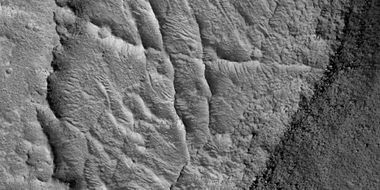
Close view of ridge networks Arrow points to small, straight ridge.

Close view of small and large ridges


Wide view of ridge network, as seen by HiRISE under HiWish program
Close view of ridge networks, as seen by HiRISE under HiWish program Arrow points to small, straight ridge.
Close view of small and large ridges, as seen by HiRISE under HiWish program
Close view of small and large ridges, as seen by HiRISE under HiWish program

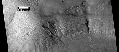
Ridges, this pictures was named HiRISE picture of the day on March 29, 2024.

Ridges, this pictures was named HiRISE picture of the day on March 29, 2024.

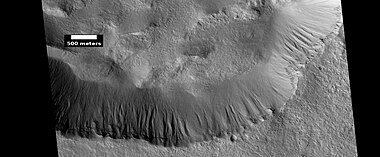
Ridges, this picture was named HiRISE picture of the day on March 29, 2024. A channel that has transverse aeolian ridges on the foor is also visible.

Close view of ridges This picture was named HiRISE picture of the day on March 29, 2024.
- ==Layers==
- Layers Location is Tempe Terra

Wide view of crater with layers near the top

Close view of layers and boulders in the wall of a trough

Close, color view of layers in a trough


Layers on crater wall


Close, color view of layers near top of crater, as seen by HiRISE underHiWish program
Other Features in the Arcadia quadrangle

Lava flows

Double crater, as seen by HiRISE under HiWish program An asteroid probably broke in two right before it impacted the surface.

Wide view of craters, layers, streaks, hollows

Close view of hollows

Ridges on crater floor

Ring mold crater This image was named HiRISE picture of the day. Ring mold craters are caused by a rebound of an ice layer after being struck by an impacting body.


See also
External links
References
- ↑ Davies, M.E.; Batson, R.M.; Wu, S.S.C. "Geodesy and Cartography" in Kieffer, H.H.; Jakosky, B.M.; Snyder, C.W.; Matthews, M.S., Eds. Mars. University of Arizona Press: Tucson, 1992.
- ↑ Distances calculated using NASA World Wind measuring tool. http://worldwind.arc.nasa.gov/.
- ↑ Blunck, J. 1982. Mars and its Satellites. Exposition Press. Smithtown, N.Y.
- ↑ USGS Gazetteer of Planetary Nomenclature. Mars. http://planetarynames.wr.usgs.gov/.
- ↑ http://www.marsartgallery.com/marsnames.html
- ↑ Skinner, J., L. Skinner, and J. Kargel. 2007. Re-assessment of Hydrovolcanism-based Resurfacing within the Galaxias Fossae Region of Mars. Lunar and Planetary Science XXXVIII (2007)
- ↑ http://hirise.lpl.arizona.edu/PSP_008641_2105
- ↑ Wyrick, D., D. Ferrill, D. Sims, and S. Colton. 2003. Distribution, Morphology and Structural Associations of Martian Pit Crater Chains. Lunar and Planetary Science XXXIV (2003)
- ↑ http://www.msss.com/mars_images/moc/2004/01/29/index.html
- ↑ Ferrill, D., D. Wyrick, A. Morris, D. Sims, and N. Franklin. 2004. Dilational fault slip and pit chain formation on Mars 14:10:4-12
- ↑ http://www.space.com/image_of_day_080730.html
- ↑ https://www.sciencedaily.com/releases/2009/02/090217101110.htm%7Caccess-date=2017-06-01%7Cdate=2009-02-19%7Ctitle=Mars Spirit Rover Gets Energy Boost From Cleaner Solar Panels|work=Science Daily
- ↑ |isbn = 0-517-00192-6|title = Atlas of the Solar System|last1 = Moore|first1 = Patrick|
- ↑ Hugh H. Kieffer|title=Mars|url=https://books.google.com/books?id=NoDvAAAAMAAJ%7Caccessdate=7 March 2011|year=1992|publisher=University of Arizona Press|
- ↑ Burleigh | first1 = Kaylan J. | last2 = Melosh | first2 = Henry J. | last3 = Tornabene | first3 = Livio L. | last4 = Ivanov | first4 = Boris | last5 = McEwen | first5 = Alfred S. | last6 = Daubar | first6 = Ingrid J. | year = 2012 | title = Impact air blast triggers dust avalanches on Mars | url = | journal = Icarus | volume = 217 | issue = 1| page = 194 | doi = 10.1016/j.icarus.2011.10.026 |
- ↑ http://redplanet.asu.edu/
- ↑ Edgett |first1= K. |last2= Malin |first2= M. C. |last3= Williams |first3= R. M. E. |last4= Davis |first4= S. D. |date= 2003 |title= Polar-and middle-latitude martian gullies: A view from MGS MOC after 2 Mars years in the mapping orbit |journal= Lunar Planet. Sci. |volume=34 |at=p. 1038, Abstract 1038 | url=http://www.lpi.usra.edu/meetings/lpsc2003/pdf/1038.pdf |
- ↑ Harrington |first=J.D. |last2=Webster |first2=Guy |title=RELEASE 14-191 – NASA Spacecraft Observes Further Evidence of Dry Ice Gullies on Mars |url=http://www.nasa.gov/press/2014/july/nasa-spacecraft-observes-further-evidence-of-dry-ice-gullies-on-mars |date=July 10, 2014 |work=NASA
- ↑ CNRS. "Gullies on Mars sculpted by dry ice rather than liquid water." ScienceDaily. ScienceDaily, 22 December 2015. www.sciencedaily.com/releases/2015/12/151222082255.htm
- ↑ http://www.skyandtelescope.com/astronomy-news/martian-gullies-triggered-by-exploding-dry-ice-122320158
- ↑ Carr, M."The Surface of Mars" Series: Cambridge Planetary Science (No. 6) ISBN|978-0-511-26688-1 Michael H. Carr, United States Geological Survey, Menlo Park
- ↑ Hugh H. Kieffer (1992). Mars. University of Arizona Press. ISBN 978-0-8165-1257-7.
- ↑ Milliken | first1 = R. E. | last2 = Mustard | first2 = J. F. | last3 = Goldsby | first3 = D. L. | year = 2003 | title = Viscous flow features on the surface of Mars: Observations from high-resolution Mars Orbiter Camera (MOC) images | url = https://semanticscholar.org/paper/a822f14644d2294b948e101be2f294ac33b57ec3%7C journal = Journal of Geophysical Research | volume = 108 | issue = E6| page = 5057 |
- ↑ Squyres | first1 = S.W. | last2 = Carr | first2 = M.H. | year = 1986 | title = Geomorphic evidence for the distribution of ground ice on Mars | url = | journal = Science | volume = 213 | issue = 4735| pages = 249–253 | doi = 10.1126/science.231.4735.249 | pmid = 17769645 |
- ↑ Head | first1 = J.W. | last2 = Marchant | first2 = D.R. | last3 = Dickson | first3 = J.L. | last4 = Kress | first4 = A.M. | year = 2010 | title = Criteria for the recognition of debris-covered glacier and valley glacier landsystem deposits | url = | journal = Earth Planet. Sci. Lett. | volume = 294 | issue = | pages = 306–320 | doi=10.1016/j.epsl.2009.06.041 |
- ↑ Holt | first1 = J.W. |display-authors=et al | year = 2008 | title = Radar sounding evidence for buried glaciers in the southern mid-latitudes of Mars | url = | journal = Science | volume = 322 | issue = 5905| pages = 1235–1238 | doi=10.1126/science.1164246 | pmid=19023078|
- ↑ Morgan | first1 = G.A. | last2 = Head | first2 = J.W. | last3 = Marchant | first3 = D.R. | year = 2009 | title = Lineated valley fill (LVF) and lobate debris aprons (LDA) in the Deuteronilus Mensae northern dichotomy boundary region, Mars: Constraints on the extent, age and episodicity of Amazonian glacial events | url = | journal = Icarus | volume = 202 | issue = 1| pages = 22–38 | doi=10.1016/j.icarus.2009.02.017 |
- ↑ Plaut | first1 = J.J. | last2 = Safaeinili | first2 = A. | last3 = Holt | first3 = J.W. | last4 = Phillips | first4 = R.J. | last5 = Head | first5 = J.W. | last6 = Sue | first6 = R. | last7 = Putzig | first7 = A. | year = 2009 | title = Frigeri Radar evidence for ice in lobate debris aprons in the mid-northern latitudes of Mars | url = https://semanticscholar.org/paper/f6b94761e6a276ce6894374ae9bea88fdc3e5e19%7C journal = Geophys. Res. Lett. | volume = 36 | issue = 2| page = L02203 | doi=10.1029/2008gl036379|
- ↑ Baker | first1 = D.M.H. | last2 = Head | first2 = J.W. | last3 = Marchant | first3 = D.R. | year = 2010 | title = Flow patterns of lobate debris aprons and lineated valley fill north of Ismeniae Fossae, Mars: Evidence for extensive mid-latitude glaciation in the Late Amazonian | url = | journal = Icarus | volume = 207 | issue = 1| pages = 186–209 |
- ↑ Arfstrom | first1 = J. | year = 2005 | title = Terrestrial analogs and interrelationships | url = | journal = Icarus | volume = 174 | issue = 2| pages = 321–335 | doi=10.1016/j.icarus.2004.05.026 |
- ↑ Carr | first1 = M | year = 2001 | title = Mars Global Surveyor observations of martian fretted terrain | url = | journal = J. Geophys. Res. | volume = 106 | issue = | pages = 23571–23593 |
- ↑ Head, J., J. Mustard. 2006. Breccia dikes and crater-related faults in impact craters on Mars: Erosion and exposure on the floor of a crater 75 km in diameter at the dichotomy boundary, Meteorit. Planet Science: 41, 1675-1690.
- ↑ Moore, J., D. Wilhelms. 2001. Hellas as a possible site of ancient ice-covered lakes on Mars. Icarus: 154, 258-276.


