Difference between revisions of "Ismenius Lacus quadrangle"
(added see also section) |
(added info, ref, pictures) |
||
| Line 14: | Line 14: | ||
</gallery> | </gallery> | ||
[[Category:Mars Atlas]] | [[Category:Mars Atlas]] | ||
| + | |||
| + | |||
| + | This quadrangle has some of the most mysterious-looking landscapes on the planet. It truly looks like another world here. The Ismenius Lacus quadrangle contains regions called Deuteronilus Mensae and Protonilus Mensae, two places that are of special interest to scientists. They contain abundant evidence of present and past glacial activity. They also have a landscape unique to Mars, called Fretted terrain. The largest crater in the area is Lyot Crater, which contains channels probably carved by liquid water.<ref>Carter | first1 = J. | last2 = Poulet | first2 = F. | last3 = Bibring | first3 = J.-P. | last4 = Murchie | first4 = S. | year = 2010 | title = Detection of Hydrated Silicates in Crustal Outcrops in the Northern Plains of Mars | url = | journal = Science | volume = 328 | issue = 5986| pages = 1682–1686 | | ||
| + | The Ismenius Lacus quadrangle is located in the northern hemisphere and covers 30° to 65° north latitude and 300° to 360° west longitude (60° to 0° east longitude). The southern and northern borders of the Ismenius Lacus quadrangle are approximately 3065 km (1,905 mi) and 1500 km wide (930 mi) respectively. The north-to-south distance is about 2050 km (1,270 mi) (a bit less than the length of Greenland).<ref>Distances calculated using NASA World Wind measuring tool. http://worldwind.arc.nasa.gov/.</ref> The Ismenius Lacus quadrangle contains parts of regions named Acidalia Planitia, Arabia Terra, Vastitas Borealis, and Terra Sabaea.<ref>http://planetarynames.wr.usgs.gov/SearchResults?target=MARS&featureType=Terra,%20terrae</ref> | ||
| + | |||
| + | ==Origin of names== | ||
| + | Ismenius Lacus is the name of a classical albedo feature located at 40° N and 30° E on Mars. The term is Latin for Ismenian Lake, and refers to the Ismenian Spring near Thebes in Greece where Cadmus slew the guardian dragon. Cadmus was the legendary founder of Thebes, and had come to the spring to fetch water. The name was approved by the International Astronomical Union (IAU) in 1958.<ref>USGS Gazetteer of Planetary Nomenclature. Mars. http://planetarynames.wr.usgs.gov/.</ref> All names suggested for astronomical features have to eventually approved by the International Astronomical Union (IAU). | ||
| + | Some important areas in this quadrangle derive from the names of canals that some early astronomers saw in this broad area. One such large canal they called Nilus. Since 1881–1882 it was split into other canals, some were called Nilosyrtis, Protonilus (first Nile),and Deuteronilus (second Nile).<ref>Blunck, J. 1982. Mars and its Satellites. Exposition Press. Smithtown, N.Y.</ref> | ||
| + | |||
| + | ==Channels (Rivers)== | ||
| + | Many features were probably rivers with water flowing in them billions of years ago. | ||
| + | In eastern Ismenius Lacus, lies Mamers Valles, a giant outflow channel. | ||
| + | |||
| + | <gallery class="center" widths="190px" heights="180px"> | ||
| + | Image:Mamers Valles Cliff.jpg|Wide view of [[Mamers Vallis]] with cliffs, as seen by [[HiRISE]] | ||
| + | Image:Mamers Valles Smooth Cliff.JPG|Smooth cliff of Mamers Valles. Note the lack of boulders. Much of the surface may have just been blown in or dropped from the sky (as dirty frost). Image from HiRISE. | ||
| + | Image:Mamers Valles Layer Deposit.JPG|Layered deposit in Mamers Valles, as seen by HiRISE. | ||
| + | </gallery> | ||
| + | |||
| + | The channel shown below goes quite a long distance and has branches. It ends in a depression that may have been a lake at one time. The first picture is a wide angle, taken with CTX; while the second is a close up taken with HiRISE.<ref>http://www.uahirise.org/ESP_039997_2170</ref> | ||
| + | |||
| + | <gallery class="center" widths="190px" heights="180px"> | ||
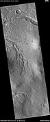
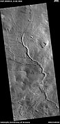
| + | Wikichannelsarabia.jpg|Channels in Arabia, as seen by CTX This channel winds along for a good distance and has branches. It ends in a depression that may have been a lake at one time. | ||
| + | WikiESP 039997 2170channels.jpg|Channel in Arabia, as seen by HiRISE under [[HiWish program]]. This is an enlargement of the previous image that was taken with CTX to give a wide view. | ||
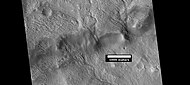
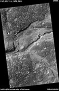
| + | ESP 039931 2165channels.jpg|Channel within larger channel, as seen by HiRISE under HiWish program The existence of the smaller channel suggests water went through the region at least two times in the past. | ||
| + | ESP 039931 2165close.jpg|Close-up of channel within larger channel, as seen by HiRISE under HiWish program The existence of the smaller channel suggests water went through the region at least two times in the past. The black box represents the size of a football field. Some parts of the surface would be difficult to walk on with the many small hills and depressions. | ||
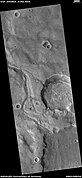
| + | ESP 042924 2195channel.jpg|Channel system that travels through part of a crater, as seen by HiRISE under HiWish program | ||
| + | ESP 045548 2155channel.jpg|Channel that cut through a crater rim, as seen by HiRISE under HiWish program | ||
| + | 42924 2195channelnetwork.jpg|Channel system that travels through part of a crater, as seen by HiRISE under HiWish program Note: this is an enlargement of a previous image. | ||
| + | 42924 2195channel.jpg|Channel that travels through part of a crater, as seen by HiRISE under HiWish program The arrow shows a crater that was eroded by the channel. Note: this is an enlargement of a previous image. | ||
| + | ESP 042502 2200channels.jpg|Channels, as seen by HiRISE under HiWish program | ||
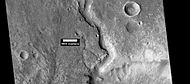
| + | ESP 043623 2160meander.jpg|Meander in a channel, as seen by HiRISE under HiWish program Meanders are commonly formed in old river systems when the water is moving slowly. | ||
| + | ESP 045837 2245channels.jpg|Wide view of channels, as seen by HiRISE under HiWish program | ||
| + | 45837 2245channel.jpg|Close view of channel, as seen by HiRISE under HiWish program | ||
| + | ESP 045838 2130channel.jpg|Channel that has cut through a crater rim, as seen by HiRISE under HiWish program | ||
| + | ESP 045850 2210channels.jpg|Wide view of channels, as seen by HiRISE under HiWish program | ||
| + | ESP 045864 2160channels.jpg|Wide view of channels, as seen by HiRISE under HiWish program | ||
| + | ESP 045904 2145channelstop.jpg|Channel, as seen by HiRISE under HiWish program | ||
| + | ESP 045916 2205channels.jpg|Wide view of channels, as seen by HiRISE under HiWish program | ||
| + | 45916 2205hanging.jpg|Channel with hanging valley, as seen by HiRISE under HiWish program | ||
| + | ESP 046010 2160channels.jpg|Wide view of channels, as seen by HiRISE under HiWish program | ||
| + | ESP 046049 2140channels.jpg|Wide view of channels, as seen by HiRISE under HiWish program | ||
| + | ESP 046458 2160channel.jpg|Channel, as seen by HiRISE under HiWish program | ||
| + | ESP 050914 2130channel.jpg|Channels, as seen by HiRISE under HiWish program | ||
| + | |||
| + | ESP 052761 2170channel.jpg|Channels, as seen by HiRISE under HiWish program | ||
| + | ESP 052774 2160mantle.jpg|Channels, as seen by HiRISE under HiWish program Some parts of the image show mantle and others show no mantle covering the surface. | ||
| + | File:ESP 053420 2160inverted channel.jpg|Possible inverted channel, as seen by HiRISE under HiWish program | ||
| + | </gallery> | ||
| + | |||
==See also== | ==See also== | ||
Revision as of 09:25, 7 March 2020
| MC-05 | Ismenius Lacus | 30–65° N | 0–60° E | Quadrangles | Atlas |
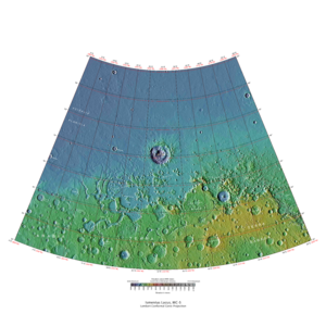
Elevations


This quadrangle has some of the most mysterious-looking landscapes on the planet. It truly looks like another world here. The Ismenius Lacus quadrangle contains regions called Deuteronilus Mensae and Protonilus Mensae, two places that are of special interest to scientists. They contain abundant evidence of present and past glacial activity. They also have a landscape unique to Mars, called Fretted terrain. The largest crater in the area is Lyot Crater, which contains channels probably carved by liquid water.Cite error: Closing </ref> missing for <ref> tag The Ismenius Lacus quadrangle contains parts of regions named Acidalia Planitia, Arabia Terra, Vastitas Borealis, and Terra Sabaea.[1]
Origin of names
Ismenius Lacus is the name of a classical albedo feature located at 40° N and 30° E on Mars. The term is Latin for Ismenian Lake, and refers to the Ismenian Spring near Thebes in Greece where Cadmus slew the guardian dragon. Cadmus was the legendary founder of Thebes, and had come to the spring to fetch water. The name was approved by the International Astronomical Union (IAU) in 1958.[2] All names suggested for astronomical features have to eventually approved by the International Astronomical Union (IAU). Some important areas in this quadrangle derive from the names of canals that some early astronomers saw in this broad area. One such large canal they called Nilus. Since 1881–1882 it was split into other canals, some were called Nilosyrtis, Protonilus (first Nile),and Deuteronilus (second Nile).[3]
Channels (Rivers)
Many features were probably rivers with water flowing in them billions of years ago. In eastern Ismenius Lacus, lies Mamers Valles, a giant outflow channel.
- Mamers Valles Cliff.jpg
Wide view of Mamers Vallis with cliffs, as seen by HiRISE
- Mamers Valles Smooth Cliff.JPG
Smooth cliff of Mamers Valles. Note the lack of boulders. Much of the surface may have just been blown in or dropped from the sky (as dirty frost). Image from HiRISE.
- Mamers Valles Layer Deposit.JPG
Layered deposit in Mamers Valles, as seen by HiRISE.
The channel shown below goes quite a long distance and has branches. It ends in a depression that may have been a lake at one time. The first picture is a wide angle, taken with CTX; while the second is a close up taken with HiRISE.[4]
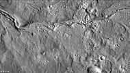
Channels in Arabia, as seen by CTX This channel winds along for a good distance and has branches. It ends in a depression that may have been a lake at one time.

Channel in Arabia, as seen by HiRISE under HiWish program. This is an enlargement of the previous image that was taken with CTX to give a wide view.

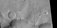
Channel within larger channel, as seen by HiRISE under HiWish program The existence of the smaller channel suggests water went through the region at least two times in the past.

Close-up of channel within larger channel, as seen by HiRISE under HiWish program The existence of the smaller channel suggests water went through the region at least two times in the past. The black box represents the size of a football field. Some parts of the surface would be difficult to walk on with the many small hills and depressions.

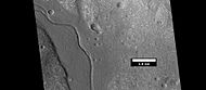
Channel system that travels through part of a crater, as seen by HiRISE under HiWish program

Channel that cut through a crater rim, as seen by HiRISE under HiWish program
Channel system that travels through part of a crater, as seen by HiRISE under HiWish program Note: this is an enlargement of a previous image.

Channel that travels through part of a crater, as seen by HiRISE under HiWish program The arrow shows a crater that was eroded by the channel. Note: this is an enlargement of a previous image.

Channels, as seen by HiRISE under HiWish program

Meander in a channel, as seen by HiRISE under HiWish program Meanders are commonly formed in old river systems when the water is moving slowly.

Wide view of channels, as seen by HiRISE under HiWish program
Close view of channel, as seen by HiRISE under HiWish program

Channel that has cut through a crater rim, as seen by HiRISE under HiWish program
Wide view of channels, as seen by HiRISE under HiWish program
Wide view of channels, as seen by HiRISE under HiWish program
Channel, as seen by HiRISE under HiWish program

Wide view of channels, as seen by HiRISE under HiWish program

Channel with hanging valley, as seen by HiRISE under HiWish program

Wide view of channels, as seen by HiRISE under HiWish program

Wide view of channels, as seen by HiRISE under HiWish program
Channel, as seen by HiRISE under HiWish program
Channels, as seen by HiRISE under HiWish program
Channels, as seen by HiRISE under HiWish program

Channels, as seen by HiRISE under HiWish program Some parts of the image show mantle and others show no mantle covering the surface.

Possible inverted channel, as seen by HiRISE under HiWish program


See also
- Dark slope streaks
- Geography of Mars
- High Resolution Imaging Science Experiment (HiRISE)
- HiWish program
- How are features on Mars Named?
- Layers on Mars
- Mars Global Surveyor


