Difference between revisions of "Ismenius Lacus quadrangle"
m |
|||
| Line 152: | Line 152: | ||
The Ismenius Lacus quadrangle contains several interesting features such as fretted terrain, parts of which are found in Deuteronilus Mensae and Protonilus Mensae. Fretted terrain contains smooth, flat lowlands along with steep cliffs. The scarps or cliffs are usually 1 to 2 km high. Channels in the area have wide, flat floors and steep walls. Many buttes and mesas are present. In fretted terrain the land seems to transition from narrow straight valleys to isolated mesas.<ref>Sharp, R. 1973. Mars Fretted and chaotic terrains. J. Geophys. Res.: 78. 4073–4083</ref> Most of the mesas are surrounded by forms that have been called a variety of names: circum-mesa aprons, debris aprons, rock glaciers, and lobate debris apron (LDA)s. The flat floors here often display many lines or lineations that scientists call lineated valley fill (LVF). These are cause by glacier-like flow. <ref>http://www.lpi.usra.edu/meetings/lpsc2000/pdf/1053.pdf</ref> At first they appeared to resemble rock glaciers on Earth. But scientists could not be sure. Even after the Mars Global Surveyor (MGS) Mars Orbiter Camera (MOC) took a variety of pictures of fretted terrain, experts could not tell for sure if material was moving or flowing as it would in an ice-rich deposit (glacier). Eventually, proof of their true nature was discovered by radar studies with the [[Mars Reconnaissance Orbiter]] showed that they contain pure water ice covered with a thin layer of rocks that insulated the ice.<ref>Plaut, J. et al. 2008. Radar Evidence for Ice in Lobate Debris Aprons in the Mid-Northern Latitudes of Mars. Lunar and Planetary Science XXXIX. 2290.pdf</ref> <ref>Plaut | first1 = J. | last2 = Safaeinili | first2 = A. | last3 = Holt | first3 = J. | last4 = Phillips | first4 = R. | last5 = Head | first5 = J. | last6 = Seu | first6 = R. | last7 = Putzig | first7 = N. | last8 = Frigeri | first8 = A. | year = 2009 | title = Radar evidence for ice in lobate debris aprons in the midnorthern latitudes of Mars | url = https://semanticscholar.org/paper/f6b94761e6a276ce6894374ae9bea88fdc3e5e19| journal = Geophys. Res. Lett. | volume = 36| issue = 2| pages = n/a |</ref> | The Ismenius Lacus quadrangle contains several interesting features such as fretted terrain, parts of which are found in Deuteronilus Mensae and Protonilus Mensae. Fretted terrain contains smooth, flat lowlands along with steep cliffs. The scarps or cliffs are usually 1 to 2 km high. Channels in the area have wide, flat floors and steep walls. Many buttes and mesas are present. In fretted terrain the land seems to transition from narrow straight valleys to isolated mesas.<ref>Sharp, R. 1973. Mars Fretted and chaotic terrains. J. Geophys. Res.: 78. 4073–4083</ref> Most of the mesas are surrounded by forms that have been called a variety of names: circum-mesa aprons, debris aprons, rock glaciers, and lobate debris apron (LDA)s. The flat floors here often display many lines or lineations that scientists call lineated valley fill (LVF). These are cause by glacier-like flow. <ref>http://www.lpi.usra.edu/meetings/lpsc2000/pdf/1053.pdf</ref> At first they appeared to resemble rock glaciers on Earth. But scientists could not be sure. Even after the Mars Global Surveyor (MGS) Mars Orbiter Camera (MOC) took a variety of pictures of fretted terrain, experts could not tell for sure if material was moving or flowing as it would in an ice-rich deposit (glacier). Eventually, proof of their true nature was discovered by radar studies with the [[Mars Reconnaissance Orbiter]] showed that they contain pure water ice covered with a thin layer of rocks that insulated the ice.<ref>Plaut, J. et al. 2008. Radar Evidence for Ice in Lobate Debris Aprons in the Mid-Northern Latitudes of Mars. Lunar and Planetary Science XXXIX. 2290.pdf</ref> <ref>Plaut | first1 = J. | last2 = Safaeinili | first2 = A. | last3 = Holt | first3 = J. | last4 = Phillips | first4 = R. | last5 = Head | first5 = J. | last6 = Seu | first6 = R. | last7 = Putzig | first7 = N. | last8 = Frigeri | first8 = A. | year = 2009 | title = Radar evidence for ice in lobate debris aprons in the midnorthern latitudes of Mars | url = https://semanticscholar.org/paper/f6b94761e6a276ce6894374ae9bea88fdc3e5e19| journal = Geophys. Res. Lett. | volume = 36| issue = 2| pages = n/a |</ref> | ||
| − | <gallery class="center" widths=" | + | <gallery class="center" widths="380px" heights="360px"> |
Image:Fretted terrain of Ismenius Lacus taken with MGS.JPG|Fretted terrain of Ismenius Lacus showing flat floored valleys and cliffs. Photo taken with Mars Orbiter Camera (MOC)on the [[Mars Global Surveyor]], under the MOC Public Targeting Program. The white rectangle indicates the position of a high resolution image. | Image:Fretted terrain of Ismenius Lacus taken with MGS.JPG|Fretted terrain of Ismenius Lacus showing flat floored valleys and cliffs. Photo taken with Mars Orbiter Camera (MOC)on the [[Mars Global Surveyor]], under the MOC Public Targeting Program. The white rectangle indicates the position of a high resolution image. | ||
| Line 168: | Line 168: | ||
</gallery> | </gallery> | ||
| + | |||
| + | == Glaciers == | ||
| + | |||
| + | |||
| + | Glaciers formed much of the observable surface in large areas of Mars. Much of the area in high latitudes, especially the Ismenius Lacus quadrangle, is believed to still contain enormous amounts of water ice.<ref name="Kieffer1992"/><ref name="Plaut, J. 2008"/><ref>http://www.esa.int/SPECIALS/Mars_Express/SEMBS5V681F_0.html</ref> In March 2010, scientists released the results of a radar study of an area called [[Deuteronilus Mensae]] that found widespread evidence of ice lying beneath a few meters of rock debris.<ref>http://news.discovery.com/space/mars-ice-sheet-climate.html</ref> The ice was probably deposited as snowfall during an earlier climate when the poles were tilted more.<ref>Madeleine, J. et al. 2007. Exploring the northern mid-latitude glaciation with a general circulation model. In: Seventh International Conference on Mars. Abstract 3096.</ref> It would be difficult to take a hike on the fretted terrain where glaciers are common because the surface is folded, pitted, and often covered with linear striations.<ref>http://www.uahirise.org/ESP_018857_2225</ref> The striations show the direction of movement. Much of this rough texture is due to sublimation of buried ice. The ice goes directly into a gas (this process is called sublimation) and leaves behind an empty space. Overlying material then collapses into the void.<ref>http://hirise.lpl.arizona.edu/PSP_009719_2230</ref> Glaciers are not pure ice; they contain dirt and rocks. At times, they will dump their load of materials into ridges. Such ridges are called [[moraine]]s. Some places on Mars have groups of ridges that are twisted around; this may have been due to more movement after the ridges were put into place. Sometimes chunks of ice fall from the glacier and get buried in the land surface. When they melt, a more or less round hole remains.<ref>http://hirise.lpl.arizona.edu/PSP_006278_2225</ref> On Earth we call these features kettles or kettle holes. Mendon Ponds Park in upstate New York has preserved several of these kettles. The picture from HiRISE below shows possible kettles in Moreux Crater. | ||
| + | |||
| + | <gallery class="center" widths="380px" heights="360px"> | ||
| + | |||
| + | Image:Evidence of Glaciers in Fretted terrain.JPG|The arrow in the left picture points to a possibly valley carved by a glacier. The image on the right shows the valley greatly enlarged in a Mars Global Surveyor image. | ||
| + | Image:Moreux Crater moraines.JPG|[[Moreux Crater]] moraines and kettle holes, as seen by HIRISE. | ||
| + | Image:Hypsas Valles.JPG|Clanis and Hypsas Valles, as seen by HiRISE. Ridges are probably due to glacial flow. So water ice is under a thin layer of rocks. | ||
| + | |||
| + | ESP 050176 2245glacier.jpg|Glacier moving out of valley, as seen by HiRISE under HiWish program | ||
| + | Wikielephantglacier.jpg|[[Romer Lake]]'s Elephant Foot Glacier in the Earth's Arctic, as seen by Landsat 8. This picture shows several glaciers that have the same shape as many features on Mars that are believed to also be glaciers. | ||
| + | ESP 045560 2230wideglacier.jpg|Glacier coming out of valley, as seen by HiRISE under HiWish program Location is rim of Moreux Crater. | ||
| + | |||
| + | ESP 052127 2225flow.jpg|Flow, as seen by HiRISE under HiWish program | ||
| + | ESP 052179 2215flow.jpg|Flow, as seen by HiRISE under HiWish program | ||
| + | |||
| + | Image:Tributary Glacier.JPG|Tributary [[Glacier]], as seen by HiRISE | ||
| + | |||
| + | ESP 049476 2235glaciers.jpg|Glaciers moving form valleys in a mesa, as seen by HiRISE under HiWish program | ||
| + | |||
| + | ESP 046021 2175glaciers.jpg|Two glaciers interacting, as seen by HiRISE under HiWish program The one on the left is more recent and is flowing on top of the other one. | ||
| + | |||
| + | ESP 049410 2245flow.jpg|Glacier interacting with an obstacle, as seen by HiRISE under HiWish program | ||
| + | |||
| + | 46075 2200glacier.jpg|Glacier flowing out of valley, as seen by HiRISE under HiWish program | ||
| + | Image:CTX context image labeled.JPG|CTX context image showing location of next HiRISE image (letter A box). | ||
| + | Image:Glacier moraine in Deuteronilus Mensae.JPG|Possible moraine on the end of a past glacier on a mound in [[Deuteronilus Mensae]], as seen by HiRISE, under the HiWish program. Location of this image is the box labeled A in previous image. | ||
| + | ESP 046734 2270ridge.jpg|Ridge that is probably from an old glacier, as seen by HiRISE under HiWish program | ||
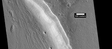
| + | Image:Coloe Fossae Lineated Valley Fill.JPG|[[Coloe Fossae]] [[lineated valley fill]], as seen by HiRISE. Scale bar is 500 meters long. | ||
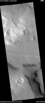
| + | ESP 046061 2190lvf.jpg|Lineated valley fill, as seen by HiRISE under [[HiWish program]]. | ||
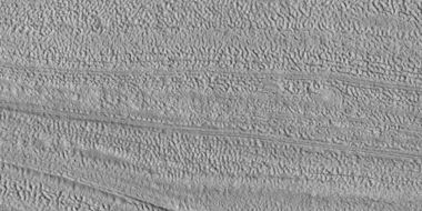
| + | 46061 2190closelvf..jpg|Close view of Lineated valley fill, as seen by HiRISE under HiWish program | ||
| + | ESP 046061 2190closebrains.jpg|Close, color view of Lineated valley fill, as seen by HiRISE under HiWish program | ||
| + | ESP 046840 2130lvf.jpg|Lineated valley fill in valley, as seen by HiRISE under HiWish program | ||
| + | |||
| + | ESP 050137 2185lvf.jpg|Lineated valley fill in valley, as seen by HiRISE under HiWish program Linear valley flow is ice covered by debris. | ||
| + | |||
| + | ESP 050137 2185lvfclosecolor.jpg|Close, color view of lineated valley fill, as seen by HiRISE under HiWish program | ||
| + | |||
| + | Image:Face of Lobate Debris Apron.jpg|Place where a lobate debris apron begins. Note stripes which indicate movement. Image located in Ismenius Lacus quadrangle. [[Lobate debris apron]]s have been shown to contain almost pure water ice covered over with a layer of rocky debris. | ||
| + | Image:Lobate feature with hiwish.JPG|Probable glacier as seen by HiRISE under HiWish program Radar studies have found that it is made up of almost completely pure ice. It appears to be moving from the high ground (a mesa) on the right. | ||
| + | Image:Glacier as seen by ctx.JPG|Mesa in Ismenius Lacus quadrangle, as seen by CTX. Mesa has several glaciers eroding it. One of the glaciers is seen in greater detail in the next two images from HiRISE. | ||
| + | Image:Wide view of glacier showing image field.JPG|Glacier as seen by HiRISE under the HiWish program. Area in rectangle is enlarged in the next photo. Zone of accumulation of snow at the top. Glacier is moving down valley, then spreading out on plain. Evidence for flow comes from the many lines on surface. Location is in [[Protonilus Mensae]] in Ismenius Lacus quadrangle. | ||
| + | Image:Glacier close up with hirise.JPG|Enlargement of area in rectangle of the previous image. On Earth the ridge would be called the terminal moraine of an alpine glacier. Picture taken with HiRISE under the HiWish program. | ||
| + | ESP 045415 2220glacier.jpg|Flow ridges from a previous glacier, as seen by HiRISE under HiWish program. | ||
| + | Image:20769flow_features.jpg|Remains of glaciers, as seen by HiRISE under the HiWish program. | ||
| + | Image:ESP 028352 2245glacier.jpg|Remains of a glacier after ice has disappeared, as seen by HiRISE under HiWish program. | ||
| + | File:33534_2160drumlins.jpg|Arrows point to drumlin-like shapes that were probably formed under a glacier, as seen by HiRISE, under HiWish program. | ||
| + | Wikildaf03 036777 2287.jpg|Lobate debris aprons (LDAs) around a mesa, as seen by CTX Mesa and LDAs are labeled so one can see their relationship. Radar studies have determined that LDAs contain ice; therefore these can be important for future colonists of Mars. Location is Ismenius Lacus quadrangle. | ||
| + | WikiESP 036777 2290lda.jpg|Close-up of lobate debris apron (LDA), as seen by HiRISE under HiWish program | ||
| + | Wikifrettedctxpo5.jpg|Wide CTX view of mesa showing lobate debris apron (LDA) and lineated valley fill. Both are believed to be debris-covered glaciers. Location is Ismenius Lacus quadrangle. | ||
| + | Wikifretesp 027639 2210lda.jpg|Close-up of lobate debris apron from the previous CTX image of a mesa. Image shows open-cell brain terrain and closed-cell [[brain terrain]], which is more common. Open-cell brain terrain is thought to hold a core of ice. Image is from HiRISE under HiWish program. | ||
| + | |||
| + | File:ESP 057389 2195flow.jpg|Lobate debris apron around mesa, as seen by HiRISE under HiWish program | ||
| + | |||
| + | File:ESP 057389 2195lda.jpg|Close view of lobate debris apron around mesa, as seen by HiRISE under HiWish program Brain terrain is visible. | ||
| + | |||
| + | ESP 044874 2205glaciers.jpg|Glaciers moving in two different valleys, as seen by HiRISE under HiWish program | ||
| + | ESP 045085 2205flow.jpg|Wide view of flow moving down valley, as seen by HiRISE under HiWish program | ||
| + | 45085 2205close.jpg|Close view of part of glacier, as seen by HiRISE under HiWish program Box shows size of football field. | ||
| + | |||
| + | ESP 051177 2230flowmantle.jpg|Flow and mantle, as seen by HiRISE under HiWish program | ||
| + | ESP 051177 2230flowclosecolor.jpg|Close, color view of flow, as seen by HiRISE under HiWish program | ||
| + | </gallery> | ||
| + | |||
| + | <gallery class="center" widths="190px" heights="180px"> | ||
| + | ESP 049555 2225tongue.jpg|Wide view of tongue-shaped glacier and lineated valley fill, as seen by HiRISE under HiWish program | ||
| + | |||
| + | 49555 2225tongue.jpg|Tongue-shaped glacier, as seen by HiRISE under HiWish program Note: this is an enlargement of the previous image | ||
| + | 49555 2225tongueclose.jpg|Close view of tongue-shaped glacier, as seen by HiRISE under HiWish program Surface is broken up into cubes. | ||
| + | </gallery> | ||
| + | |||
==See also== | ==See also== | ||
Revision as of 12:14, 7 March 2020
| MC-05 | Ismenius Lacus | 30–65° N | 0–60° E | Quadrangles | Atlas |
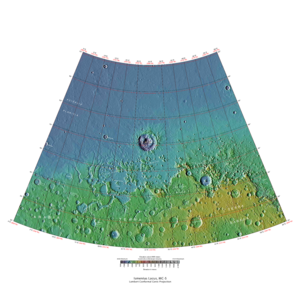
Elevations


This quadrangle has some of the most mysterious-looking landscapes on the planet. It truly looks like another world here. The Ismenius Lacus quadrangle contains regions called Deuteronilus Mensae and Protonilus Mensae, two places that are of special interest to scientists. They contain abundant evidence of present and past glacial activity. They also have a landscape unique to Mars, called Fretted terrain. The largest crater in the area is Lyot Crater, which contains channels probably carved by liquid water.[1]
The Ismenius Lacus quadrangle is located in the northern hemisphere and covers 30° to 65° north latitude and 300° to 360° west longitude (60° to 0° east longitude). The southern and northern borders of the Ismenius Lacus quadrangle are approximately 3065 km (1,905 mi) and 1500 km wide (930 mi) respectively. The north-to-south distance is about 2050 km (1,270 mi) (a bit less than the length of Greenland).[2] The Ismenius Lacus quadrangle contains parts of regions named Acidalia Planitia, Arabia Terra, Vastitas Borealis, and Terra Sabaea.[3]
Contents
Origin of names
Ismenius Lacus is the name of a classical albedo feature located at 40° N and 30° E on Mars. The term is Latin for Ismenian Lake, and refers to the Ismenian Spring near Thebes in Greece where Cadmus slew the guardian dragon. Cadmus was the legendary founder of Thebes, and had come to the spring to fetch water. The name was approved by the International Astronomical Union (IAU) in 1958.[4] All names suggested for astronomical features have to eventually approved by the International Astronomical Union (IAU). Some important areas in this quadrangle derive from the names of canals that some early astronomers saw in this broad area. One such large canal they called Nilus. Since 1881–1882 it was split into other canals, some were called Nilosyrtis, Protonilus (first Nile),and Deuteronilus (second Nile).[5]
Channels (Rivers)
Many features were probably rivers with water flowing in them billions of years ago. Pictures below show many channels and parts of channels.
The channel shown below goes quite a long distance and has branches. It ends in a depression that may have been a lake at one time. The first picture is a wide angle, taken with CTX; while the second is a close up taken with HiRISE.[6]

Channels in Arabia, as seen by CTX This channel winds along for a good distance and has branches. It ends in a depression that may have been a lake at one time.

Channel in Arabia, as seen by HiRISE under HiWish program. This is an enlargement of the previous image that was taken with CTX to give a wide view.


Some places (like below) display a smaller channel within a larger, wider channel or valley. When this occurs it means water went through the region at least two times in the past. This implies that water was not here once for just a short period of time.

Channel within larger channel The existence of the smaller channel suggests water went through the region at least two times in the past.

Close-up of channel within larger channel The existence of the smaller channel suggests water went through the region at least two times in the past. The black box represents the size of a football field. Some parts of the surface would be difficult to walk on with the many small hills and depressions.


Channel system that travels through part of a crater

Channel that cut through a crater rim

Channel system that travels through part of a crater Note: this is an enlargement of a previous image.

Channel that travels through part of a crater The arrow shows a crater that was eroded by the channel. Note: this is an enlargement of a previous image.

Channels

Meander in a channel Meanders are commonly formed in old river systems when the water is moving slowly.

Wide view of channels

Close view of channel

Channel that has cut through a crater rim

Wide view of channels, as seen by HiRISE under HiWish program

Wide view of channels

Channel

Wide view of channels

Channel with hanging valley

Wide view of channels

Wide view of channels, as seen by HiRISE under HiWish program

Channel

Channels

Channels, as seen by HiRISE under HiWish program

Channels, Some parts of the image show mantle and others show no mantle covering the surface.

Possible inverted channel Here after a stream bed got filled with erosion resistant materials, the surrounding, softer landscape eroded away.


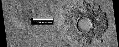
Lyot Crater
The vast northern plains of Mars are generally flat and smooth with few craters. However, a few large craters do stand out. The giant impact crater, Lyot, is easy to see in the northern part of Ismenius Lacus. There are only a very few craters along the far northern latitudes.[7] Lyot Crater is the deepest point in Mars's northern hemisphere.[8] One image below of Lyot Crater Dunes shows a variety of interesting forms: dark dunes, light-toned deposits, and Dust Devil Tracks. Dust devils, which resemble miniature tornados, create tracks by removing a thin, but bright deposit of dust to reveal the darker underlying surface. It does not take too much fine dust to cover those tracks--experiments in Earth laboratories demonstrate that only a few 10's of microns of dust will do the trick. Note on units: a micron is an older name for micrometre or micrometer. The width of a single human hair ranges from approximately 20 to 200 microns (μm); hence, the dust that can cover dust devil tracks may only be the thickness of a human hair.[9] Light-toned materials are an important find because they are widely believed to contain minerals formed in water. Research, published in June 2010, described evidence for liquid water in Lyot crater in the past.
Many channels have been found near Lyot Crater. Research, published in 2017, concluded that the channels were made from water released when the hot ejecta landed on a layer of ice that was 20 to 300 meters thick. Calculations suggest that the ejecta would have had a temperature of at least 250 degrees Fahrenheit. The valleys seem to start from beneath the ejecta near the outer edge of the ejecta. The existence of these channels is unusual because although Mars used to have water in rivers, lakes, and an ocean, these features have been dated to times after we had thought that many of these features had disappeared.[10] [11][12]

Wide view of channels in Lyot Crater, as seen by HiRISE unser HiWish program

Close view of channels in Lyot Crater

Close view of channels in Lyot Crater, as seen by HiRISE under HiWish program

Lyot Crater Dunes, as seen by HiRISE. Click on image to see light-toned deposits and dust devil tracks.

Channel


Other craters
Impact craters generally have a rim with ejecta around them; in contrast volcanic craters usually do not have a rim or ejecta deposits. As craters get larger (greater than 10 km in diameter), they usually have a central peak.[13] The peak is caused by a rebound of the crater floor following the impact.[14] Sometimes craters will display layers in their walls. Since the collision that produces a crater is like a powerful explosion, rocks from deep underground are tossed unto the surface. Hence, craters are useful for showing us what lies deep under the surface.

Fresh crater, as seen by HiRISE under HiWish program This is a young crater because one can easily see the rim and ejecta. They have not yet been eroded.

West side of Sinton Crater, as seen by CTX camera (on Mars Reconnaissance Orbiter) A central peak is visible--it occurs in larger craters and is caused by a rebound from the force of the impact.

Crater with a bench A crater with a bench may be formed from settling of the crater wall or it may be due to impact into something with vastly different types of layers.

Possible expanded secondary craters, as seen by HiRISE under HiWish program These craters may have become much wider, as ice left the ground around the rims.[15] [16]

Impact crater that may have formed in ice-rich ground, as seen by HiRISE under HiWish program

Impact crater that may have formed in ice-rich ground Note that the ejecta seems lower than the surroundings. The hot ejecta may have caused some of the ice to go away; thus lowering the level of the ejecta.
Pedestal crater The crater's ejecta protected the underlying ground from eroding.

Pedestal crater Mesa on the crater floor formed after the crater.


Valleys on the Ejecta Blanket from Cerulli Crater, as seen by HiRISE.

Cerulli Crater, as seen by HiRISE It looks like a delta was formed as channels bought in debris and dumped then in a lake that was in the crater.
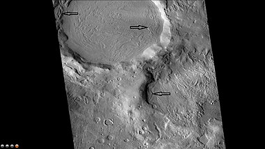
Northeast rim of Quenisset Crater, as seen by CTX camera (on Mars Reconnaissance Orbiter). Note: this is an enlargement of the previous image of Quenisset Crater. Arrows indicate old glaciers.
Group of layers in crater


Fretted terrain
The Ismenius Lacus quadrangle contains several interesting features such as fretted terrain, parts of which are found in Deuteronilus Mensae and Protonilus Mensae. Fretted terrain contains smooth, flat lowlands along with steep cliffs. The scarps or cliffs are usually 1 to 2 km high. Channels in the area have wide, flat floors and steep walls. Many buttes and mesas are present. In fretted terrain the land seems to transition from narrow straight valleys to isolated mesas.[17] Most of the mesas are surrounded by forms that have been called a variety of names: circum-mesa aprons, debris aprons, rock glaciers, and lobate debris apron (LDA)s. The flat floors here often display many lines or lineations that scientists call lineated valley fill (LVF). These are cause by glacier-like flow. [18] At first they appeared to resemble rock glaciers on Earth. But scientists could not be sure. Even after the Mars Global Surveyor (MGS) Mars Orbiter Camera (MOC) took a variety of pictures of fretted terrain, experts could not tell for sure if material was moving or flowing as it would in an ice-rich deposit (glacier). Eventually, proof of their true nature was discovered by radar studies with the Mars Reconnaissance Orbiter showed that they contain pure water ice covered with a thin layer of rocks that insulated the ice.[19] [20]

Fretted terrain of Ismenius Lacus showing flat floored valleys and cliffs. Photo taken with Mars Orbiter Camera (MOC)on the Mars Global Surveyor, under the MOC Public Targeting Program. The white rectangle indicates the position of a high resolution image.

Enlargement of the photo on the left showing cliff. Photo taken with high-resolution camera of Mars Global Surveyor (MGS), under the MOC Public Targeting Program.
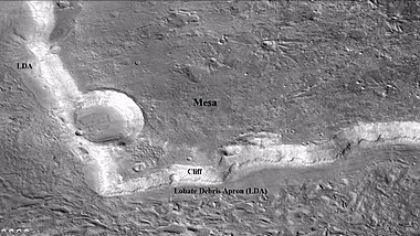
Wide view of mesa with CTX showing cliff face and location of lobate debris apron (LDA). Location is Ismenius Lacus quadrangle.

Enlargement of previous CTX image of mesa. This image shows the cliff face and detail in the LDA. Image taken with HiRISE under HiWish program. Location is Ismenius Lacus quadrangle.
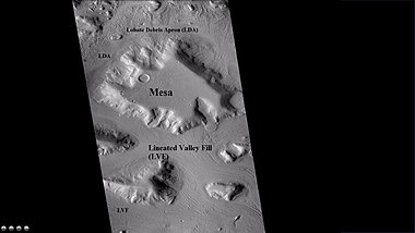
Wide CTX view showing mesa and buttes with lobate debris aprons and lineated valley fill around them. Location is Ismenius Lacus quadrangle.

Close-up of lineated valley fill (LVF), as seen by HiRISE under HiWish program. Note: this is an enlargement of the previous CTX image.

Example of frettered terrain, as seen by HiRISE under HiWish program Fretted terrain contains many wide, flat-floored valleys.


Glaciers
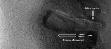
Glaciers formed much of the observable surface in large areas of Mars. Much of the area in high latitudes, especially the Ismenius Lacus quadrangle, is believed to still contain enormous amounts of water ice.[14][21][22] In March 2010, scientists released the results of a radar study of an area called Deuteronilus Mensae that found widespread evidence of ice lying beneath a few meters of rock debris.[23] The ice was probably deposited as snowfall during an earlier climate when the poles were tilted more.[24] It would be difficult to take a hike on the fretted terrain where glaciers are common because the surface is folded, pitted, and often covered with linear striations.[25] The striations show the direction of movement. Much of this rough texture is due to sublimation of buried ice. The ice goes directly into a gas (this process is called sublimation) and leaves behind an empty space. Overlying material then collapses into the void.[26] Glaciers are not pure ice; they contain dirt and rocks. At times, they will dump their load of materials into ridges. Such ridges are called moraines. Some places on Mars have groups of ridges that are twisted around; this may have been due to more movement after the ridges were put into place. Sometimes chunks of ice fall from the glacier and get buried in the land surface. When they melt, a more or less round hole remains.[27] On Earth we call these features kettles or kettle holes. Mendon Ponds Park in upstate New York has preserved several of these kettles. The picture from HiRISE below shows possible kettles in Moreux Crater.

The arrow in the left picture points to a possibly valley carved by a glacier. The image on the right shows the valley greatly enlarged in a Mars Global Surveyor image.

Moreux Crater moraines and kettle holes, as seen by HIRISE.

Clanis and Hypsas Valles, as seen by HiRISE. Ridges are probably due to glacial flow. So water ice is under a thin layer of rocks.
Glacier moving out of valley, as seen by HiRISE under HiWish program
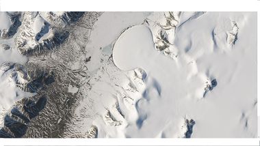
Romer Lake's Elephant Foot Glacier in the Earth's Arctic, as seen by Landsat 8. This picture shows several glaciers that have the same shape as many features on Mars that are believed to also be glaciers.

Glacier coming out of valley, as seen by HiRISE under HiWish program Location is rim of Moreux Crater.

Flow, as seen by HiRISE under HiWish program

Flow, as seen by HiRISE under HiWish program

Tributary Glacier, as seen by HiRISE

Glaciers moving form valleys in a mesa, as seen by HiRISE under HiWish program

Two glaciers interacting, as seen by HiRISE under HiWish program The one on the left is more recent and is flowing on top of the other one.

Glacier interacting with an obstacle, as seen by HiRISE under HiWish program

Glacier flowing out of valley, as seen by HiRISE under HiWish program

CTX context image showing location of next HiRISE image (letter A box).

Possible moraine on the end of a past glacier on a mound in Deuteronilus Mensae, as seen by HiRISE, under the HiWish program. Location of this image is the box labeled A in previous image.

Ridge that is probably from an old glacier, as seen by HiRISE under HiWish program

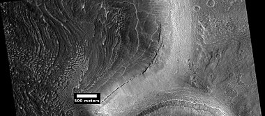
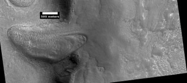
Coloe Fossae lineated valley fill, as seen by HiRISE. Scale bar is 500 meters long.
Lineated valley fill, as seen by HiRISE under HiWish program.
Close view of Lineated valley fill, as seen by HiRISE under HiWish program

Close, color view of Lineated valley fill, as seen by HiRISE under HiWish program
Lineated valley fill in valley, as seen by HiRISE under HiWish program

Lineated valley fill in valley, as seen by HiRISE under HiWish program Linear valley flow is ice covered by debris.

Close, color view of lineated valley fill, as seen by HiRISE under HiWish program

Place where a lobate debris apron begins. Note stripes which indicate movement. Image located in Ismenius Lacus quadrangle. Lobate debris aprons have been shown to contain almost pure water ice covered over with a layer of rocky debris.

Probable glacier as seen by HiRISE under HiWish program Radar studies have found that it is made up of almost completely pure ice. It appears to be moving from the high ground (a mesa) on the right.

Mesa in Ismenius Lacus quadrangle, as seen by CTX. Mesa has several glaciers eroding it. One of the glaciers is seen in greater detail in the next two images from HiRISE.

Glacier as seen by HiRISE under the HiWish program. Area in rectangle is enlarged in the next photo. Zone of accumulation of snow at the top. Glacier is moving down valley, then spreading out on plain. Evidence for flow comes from the many lines on surface. Location is in Protonilus Mensae in Ismenius Lacus quadrangle.

Enlargement of area in rectangle of the previous image. On Earth the ridge would be called the terminal moraine of an alpine glacier. Picture taken with HiRISE under the HiWish program.

Flow ridges from a previous glacier, as seen by HiRISE under HiWish program.

Remains of glaciers, as seen by HiRISE under the HiWish program.
Remains of a glacier after ice has disappeared, as seen by HiRISE under HiWish program.

Arrows point to drumlin-like shapes that were probably formed under a glacier, as seen by HiRISE, under HiWish program.
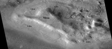
Lobate debris aprons (LDAs) around a mesa, as seen by CTX Mesa and LDAs are labeled so one can see their relationship. Radar studies have determined that LDAs contain ice; therefore these can be important for future colonists of Mars. Location is Ismenius Lacus quadrangle.

Close-up of lobate debris apron (LDA), as seen by HiRISE under HiWish program
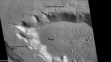
Wide CTX view of mesa showing lobate debris apron (LDA) and lineated valley fill. Both are believed to be debris-covered glaciers. Location is Ismenius Lacus quadrangle.

Close-up of lobate debris apron from the previous CTX image of a mesa. Image shows open-cell brain terrain and closed-cell brain terrain, which is more common. Open-cell brain terrain is thought to hold a core of ice. Image is from HiRISE under HiWish program.

Lobate debris apron around mesa, as seen by HiRISE under HiWish program

Close view of lobate debris apron around mesa, as seen by HiRISE under HiWish program Brain terrain is visible.

Glaciers moving in two different valleys, as seen by HiRISE under HiWish program

Wide view of flow moving down valley, as seen by HiRISE under HiWish program

Close view of part of glacier, as seen by HiRISE under HiWish program Box shows size of football field.

Flow and mantle, as seen by HiRISE under HiWish program

Close, color view of flow, as seen by HiRISE under HiWish program


Wide view of tongue-shaped glacier and lineated valley fill, as seen by HiRISE under HiWish program

Tongue-shaped glacier, as seen by HiRISE under HiWish program Note: this is an enlargement of the previous image

Close view of tongue-shaped glacier, as seen by HiRISE under HiWish program Surface is broken up into cubes.


See also
- Dark slope streaks
- Geography of Mars
- High Resolution Imaging Science Experiment (HiRISE)
- HiWish program
- How are features on Mars Named?
- Layers on Mars
- Mars Global Surveyor
- Rivers on Mars
References
- ↑ Carter | first1 = J. | last2 = Poulet | first2 = F. | last3 = Bibring | first3 = J.-P. | last4 = Murchie | first4 = S. | year = 2010 | title = Detection of Hydrated Silicates in Crustal Outcrops in the Northern Plains of Mars | url = | journal = Science | volume = 328 | issue = 5986| pages = 1682–1686 |
- ↑ Distances calculated using NASA World Wind measuring tool. http://worldwind.arc.nasa.gov/.
- ↑ http://planetarynames.wr.usgs.gov/SearchResults?target=MARS&featureType=Terra,%20terrae
- ↑ USGS Gazetteer of Planetary Nomenclature. Mars. http://planetarynames.wr.usgs.gov/.
- ↑ Blunck, J. 1982. Mars and its Satellites. Exposition Press. Smithtown, N.Y.
- ↑ http://www.uahirise.org/ESP_039997_2170
- ↑ U.S. department of the Interior U.S. Geological Survey, Topographic Map of the Eastern Region of Mars M 15M 0/270 2AT, 1991
- ↑ http://space.com/scienceastronomy/090514--mars-rivers.html
- ↑ https://en.wikipedia.org/wiki/Micrometre
- ↑ doi=10.1002/2017GL073821 | volume=44 | issue=11 | title=Extensive Amazonian-aged fluvial channels on Mars: Evaluating the role of Lyot crater in their formation | journal=Geophysical Research Letters | pages=5336–5344 | last1 = Weiss | first1 = David K.|
- ↑ Weiss, D., et al. 2017. Extensive Amazonian-aged fluvial channels on Mars: Evaluating the role of Lyot crater in their formation. Geophysical Research Letters: 44, doi:10.1002/2017GL073821.
- ↑ http://spaceref.com/mars/hot-rocks-led-to-relatively-recent-water-carved-valleys-on-mars.html
- ↑ http://www.lpi.usra.edu/publications/slidesets/stones/
- ↑ 14.0 14.1 Template:Cite book
- ↑ http://www.uahirise.org/epo/nuggets/expanded-secondary.pdf
- ↑ Viola, D., et al. 2014. EXPANDED CRATERS IN ARCADIA PLANITIA: EVIDENCE FOR >20 MYR OLD SUBSURFACE ICE. Eighth International Conference on Mars (2014). 1022pdf.
- ↑ Sharp, R. 1973. Mars Fretted and chaotic terrains. J. Geophys. Res.: 78. 4073–4083
- ↑ http://www.lpi.usra.edu/meetings/lpsc2000/pdf/1053.pdf
- ↑ Plaut, J. et al. 2008. Radar Evidence for Ice in Lobate Debris Aprons in the Mid-Northern Latitudes of Mars. Lunar and Planetary Science XXXIX. 2290.pdf
- ↑ Plaut | first1 = J. | last2 = Safaeinili | first2 = A. | last3 = Holt | first3 = J. | last4 = Phillips | first4 = R. | last5 = Head | first5 = J. | last6 = Seu | first6 = R. | last7 = Putzig | first7 = N. | last8 = Frigeri | first8 = A. | year = 2009 | title = Radar evidence for ice in lobate debris aprons in the midnorthern latitudes of Mars | url = https://semanticscholar.org/paper/f6b94761e6a276ce6894374ae9bea88fdc3e5e19%7C journal = Geophys. Res. Lett. | volume = 36| issue = 2| pages = n/a |
- ↑ Cite error: Invalid
<ref>tag; no text was provided for refs namedPlaut, J. 2008 - ↑ http://www.esa.int/SPECIALS/Mars_Express/SEMBS5V681F_0.html
- ↑ http://news.discovery.com/space/mars-ice-sheet-climate.html
- ↑ Madeleine, J. et al. 2007. Exploring the northern mid-latitude glaciation with a general circulation model. In: Seventh International Conference on Mars. Abstract 3096.
- ↑ http://www.uahirise.org/ESP_018857_2225
- ↑ http://hirise.lpl.arizona.edu/PSP_009719_2230
- ↑ http://hirise.lpl.arizona.edu/PSP_006278_2225


