Difference between revisions of "Ismenius Lacus quadrangle"
m |
m |
||
| Line 400: | Line 400: | ||
== Pits and cracks == | == Pits and cracks == | ||
| − | Some places in the Ismenius Lacus quadrangle display large numbers of cracks and pits. It is widely believed that these are the result of ground ice sublimating (changing directly from a solid to a gas). After the ice leaves, the ground collapses in the shape of pits and cracks. The pits may come first. When enough pits form, they unite to form cracks.<ref> | + | Some places in the Ismenius Lacus quadrangle display large numbers of cracks and pits. It is widely believed that these are the result of ground ice sublimating (changing directly from a solid to a gas). After the ice leaves, the ground collapses in the shape of pits and cracks. The pits may come first. When enough pits form, they unite to form cracks.<ref>http://hirise.lpl.arizona.edu/PSP_009719_2230 |title=HiRISE | Fretted Terrain Valley Traverse (PSP_009719_2230) |publisher=Hirise.lpl.arizona.edu |</ref> |
<gallery class="center" widths="380px" heights="360px"> | <gallery class="center" widths="380px" heights="360px"> | ||
| − | + | ||
| + | |||
Image:CTX Context Image of Pits.JPG|CTX Image in [[Protonilus Mensae]], showing location of next image. | Image:CTX Context Image of Pits.JPG|CTX Image in [[Protonilus Mensae]], showing location of next image. | ||
Image:Pits in Protonilus Mensae.JPG|Pits in Protonilus Mensae, as seen by HiRISE, under the [[HiWish program]]. | Image:Pits in Protonilus Mensae.JPG|Pits in Protonilus Mensae, as seen by HiRISE, under the [[HiWish program]]. | ||
| − | |||
| − | |||
| − | |||
| − | + | Image:Pits23314.jpg|Close-up of pits, as seen by HiRISE under the HiWish program. Resolution is about 30 cm, so one could see a kitchen table if it were in the picture. | |
| + | |||
| + | |||
49700 2250pitsclose.jpg|Close view of lines of pits, as seen by HiRISE, under the HiWish program Box shows size of football field. Pits may be up to around 50 meters across. | 49700 2250pitsclose.jpg|Close view of lines of pits, as seen by HiRISE, under the HiWish program Box shows size of football field. Pits may be up to around 50 meters across. | ||
| − | + | ||
| − | + | ||
49700 2250polygons.jpg|Close view of pits and polygons, as seen by HiRISE, under the HiWish program Pits seem to occur in low spots between polygons. | 49700 2250polygons.jpg|Close view of pits and polygons, as seen by HiRISE, under the HiWish program Pits seem to occur in low spots between polygons. | ||
| − | |||
| − | |||
| − | |||
52588 2210pits.jpg|Close view of pits, as seen by HiRISE, under the HiWish program | 52588 2210pits.jpg|Close view of pits, as seen by HiRISE, under the HiWish program | ||
Revision as of 15:59, 7 March 2020
| MC-05 | Ismenius Lacus | 30–65° N | 0–60° E | Quadrangles | Atlas |

Elevations


This quadrangle has some of the most mysterious-looking landscapes on the planet. It truly looks like another world here. The Ismenius Lacus quadrangle contains regions called Deuteronilus Mensae and Protonilus Mensae, two places that are of special interest to scientists. They contain abundant evidence of present and past glacial activity. They also have a landscape unique to Mars, called Fretted terrain. The largest crater in the area is Lyot Crater, which contains channels probably carved by liquid water.[1]
The Ismenius Lacus quadrangle is located in the northern hemisphere and covers 30° to 65° north latitude and 300° to 360° west longitude (60° to 0° east longitude). The southern and northern borders of the Ismenius Lacus quadrangle are approximately 3065 km (1,905 mi) and 1500 km wide (930 mi) respectively. The north-to-south distance is about 2050 km (1,270 mi) (a bit less than the length of Greenland).[2] The Ismenius Lacus quadrangle contains parts of regions named Acidalia Planitia, Arabia Terra, Vastitas Borealis, and Terra Sabaea.[3]
Contents
Origin of names
Ismenius Lacus is the name of a classical albedo feature located at 40° N and 30° E on Mars. The term is Latin for Ismenian Lake, and refers to the Ismenian Spring near Thebes in Greece where Cadmus slew the guardian dragon. Cadmus was the legendary founder of Thebes, and had come to the spring to fetch water. The name was approved by the International Astronomical Union (IAU) in 1958.[4] All names suggested for astronomical features have to eventually approved by the International Astronomical Union (IAU). Some important areas in this quadrangle derive from the names of canals that some early astronomers saw in this broad area. One such large canal they called Nilus. Since 1881–1882 it was split into other canals, some were called Nilosyrtis, Protonilus (first Nile),and Deuteronilus (second Nile).[5]
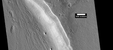
Channels (Rivers)
Many features were probably rivers with water flowing in them billions of years ago. Pictures below show many channels and parts of channels.
The channel shown below goes quite a long distance and has branches. It ends in a depression that may have been a lake at one time. The first picture is a wide angle, taken with CTX; while the second is a close up taken with HiRISE.[6]

Channels in Arabia, as seen by CTX This channel winds along for a good distance and has branches. It ends in a depression that may have been a lake at one time.

Channel in Arabia, as seen by HiRISE under HiWish program. This is an enlargement of the previous image that was taken with CTX to give a wide view.


Some places (like below) display a smaller channel within a larger, wider channel or valley. When this occurs it means water went through the region at least two times in the past. This implies that water was not here once for just a short period of time.

Channel within larger channel The existence of the smaller channel suggests water went through the region at least two times in the past.

Close-up of channel within larger channel The existence of the smaller channel suggests water went through the region at least two times in the past. The black box represents the size of a football field. Some parts of the surface would be difficult to walk on with the many small hills and depressions.


Channel system that travels through part of a crater

Channel that cut through a crater rim

Channel system that travels through part of a crater Note: this is an enlargement of a previous image.

Channel that travels through part of a crater The arrow shows a crater that was eroded by the channel. Note: this is an enlargement of a previous image.

Channels
- ESP 043623 2160meander.jpg
Meander in a channel Meanders are commonly formed in old river systems when the water is moving slowly.

Wide view of channels

Close view of channel

Channel that has cut through a crater rim

Wide view of channels, as seen by HiRISE under HiWish program

Wide view of channels

Channel

Wide view of channels

Channel with hanging valley

Wide view of channels

Wide view of channels, as seen by HiRISE under HiWish program

Channel

Channels

Channels, as seen by HiRISE under HiWish program

Channels, Some parts of the image show mantle and others show no mantle covering the surface.

Possible inverted channel Here after a stream bed got filled with erosion resistant materials, the surrounding, softer landscape eroded away.


Lyot Crater
The vast northern plains of Mars are generally flat and smooth with few craters. However, a few large craters do stand out. The giant impact crater, Lyot, is easy to see in the northern part of Ismenius Lacus. There are only a very few craters along the far northern latitudes.[7] Lyot Crater is the deepest point in Mars's northern hemisphere.[8] One image below of Lyot Crater Dunes shows a variety of interesting forms: dark dunes, light-toned deposits, and Dust Devil Tracks. Dust devils, which resemble miniature tornados, create tracks by removing a thin, but bright deposit of dust to reveal the darker underlying surface. It does not take too much fine dust to cover those tracks--experiments in Earth laboratories demonstrate that only a few 10's of microns of dust will do the trick. Note on units: a micron is an older name for micrometre or micrometer. The width of a single human hair ranges from approximately 20 to 200 microns (μm); hence, the dust that can cover dust devil tracks may only be the thickness of a human hair.[9] Light-toned materials are an important find because they are widely believed to contain minerals formed in water. Research, published in June 2010, described evidence for liquid water in Lyot crater in the past.
Many channels have been found near Lyot Crater. Research, published in 2017, concluded that the channels were made from water released when the hot ejecta landed on a layer of ice that was 20 to 300 meters thick. Calculations suggest that the ejecta would have had a temperature of at least 250 degrees Fahrenheit. The valleys seem to start from beneath the ejecta near the outer edge of the ejecta. The existence of these channels is unusual because although Mars used to have water in rivers, lakes, and an ocean, these features have been dated to times after we had thought that many of these features had disappeared.[10] [11][12]
- ESP 045389 2295lyotchannels.jpg
Wide view of channels in Lyot Crater, as seen by HiRISE unser HiWish program

Close view of channels in Lyot Crater

Close view of channels in Lyot Crater, as seen by HiRISE under HiWish program

Lyot Crater Dunes, as seen by HiRISE. Click on image to see light-toned deposits and dust devil tracks.

Channel


Other craters
Impact craters generally have a rim with ejecta around them; in contrast volcanic craters usually do not have a rim or ejecta deposits. As craters get larger (greater than 10 km in diameter), they usually have a central peak.[13] The peak is caused by a rebound of the crater floor following the impact.[14] Sometimes craters will display layers in their walls. Since the collision that produces a crater is like a powerful explosion, rocks from deep underground are tossed unto the surface. Hence, craters are useful for showing us what lies deep under the surface.

Fresh crater, as seen by HiRISE under HiWish program This is a young crater because one can easily see the rim and ejecta. They have not yet been eroded.

West side of Sinton Crater, as seen by CTX camera (on Mars Reconnaissance Orbiter) A central peak is visible--it occurs in larger craters and is caused by a rebound from the force of the impact.

Crater with a bench A crater with a bench may be formed from settling of the crater wall or it may be due to impact into something with vastly different types of layers.

Possible expanded secondary craters, as seen by HiRISE under HiWish program These craters may have become much wider, as ice left the ground around the rims.[15] [16]

Impact crater that may have formed in ice-rich ground, as seen by HiRISE under HiWish program

Impact crater that may have formed in ice-rich ground Note that the ejecta seems lower than the surroundings. The hot ejecta may have caused some of the ice to go away; thus lowering the level of the ejecta.

Pedestal crater The crater's ejecta protected the underlying ground from eroding.

Pedestal crater Mesa on the crater floor formed after the crater.


- Cerulli Crater Ejecta Valleys.JPG
Valleys on the Ejecta Blanket from Cerulli Crater, as seen by HiRISE.

Cerulli Crater, as seen by HiRISE It looks like a delta was formed as channels bought in debris and dumped then in a lake that was in the crater.
- Wikiquenissetglaciers.jpg
Northeast rim of Quenisset Crater, as seen by CTX camera (on Mars Reconnaissance Orbiter). Note: this is an enlargement of the previous image of Quenisset Crater. Arrows indicate old glaciers.

Group of layers in crater


Deltas
Researchers have found a number of examples of deltas that formed in Martian lakes. Deltas are major signs that Mars once had a lot of water because deltas usually require deep water over a long period of time to form. In addition, the water level needs to be stable to keep sediment from washing away. Deltas have been found over a wide geographical range. Below, is a pictures of a one in the Ismenius Lacus quadrangle.[17]
Delta in Ismenius Lacus quadrangle, as seen by THEMIS.
Fretted terrain
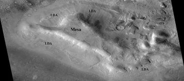
The Ismenius Lacus quadrangle contains several interesting features such as fretted terrain, parts of which are found in Deuteronilus Mensae and Protonilus Mensae. Fretted terrain contains smooth, flat lowlands along with steep cliffs. The scarps or cliffs are usually 1 to 2 km high. Channels in the area have wide, flat floors and steep walls. Many buttes and mesas are present. In fretted terrain the land seems to transition from narrow straight valleys to isolated mesas.[18] Most of the mesas are surrounded by forms that have been called a variety of names: circum-mesa aprons, debris aprons, rock glaciers, and lobate debris apron (LDA)s. The flat floors here often display many lines or lineations that scientists call lineated valley fill (LVF). These are cause by glacier-like flow. [19] At first they appeared to resemble rock glaciers on Earth. But scientists could not be sure. Even after the Mars Global Surveyor (MGS) Mars Orbiter Camera (MOC) took a variety of pictures of fretted terrain, experts could not tell for sure if material was moving or flowing as it would in an ice-rich deposit (glacier). Eventually, proof of their true nature was discovered by radar studies with the Mars Reconnaissance Orbiter showed that they contain pure water ice covered with a thin layer of rocks that insulated the ice.[20] [21]

Fretted terrain of Ismenius Lacus showing flat floored valleys and cliffs. Photo taken with Mars Orbiter Camera (MOC)on the Mars Global Surveyor, under the MOC Public Targeting Program. The white rectangle indicates the position of a high resolution image.

Enlargement of the photo on the left showing cliff. Photo taken with high-resolution camera of Mars Global Surveyor (MGS), under the MOC Public Targeting Program.

Wide view of mesa with CTX showing cliff face and location of lobate debris apron (LDA). Location is Ismenius Lacus quadrangle.

Enlargement of previous CTX image of mesa. This image shows the cliff face and detail in the LDA. Image taken with HiRISE under HiWish program. Location is Ismenius Lacus quadrangle.
- Wikifrettedctxp22.jpg
Wide CTX view showing mesa and buttes with lobate debris aprons and lineated valley fill around them. Location is Ismenius Lacus quadrangle.

Close-up of lineated valley fill (LVF), as seen by HiRISE under HiWish program. Note: this is an enlargement of the previous CTX image.

Example of frettered terrain, as seen by HiRISE under HiWish program Fretted terrain contains many wide, flat-floored valleys.


Glaciers
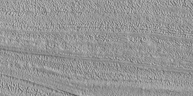
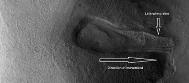
The Ismenius Lacus quadrangle might well be called the land of glaciers. Glaciers formed much of the observable surface in large areas of Mars. Much of the area in high latitudes, especially the Ismenius Lacus quadrangle, is believed to still contain enormous amounts of water ice.[22] [23] [24] In March 2010, scientists released the results of a radar study of an area called Deuteronilus Mensae that found widespread evidence of ice lying beneath a few meters of rock debris.[25] The ice was probably deposited as snowfall during an earlier climate when the poles were tilted more.[26] It would be difficult to take a hike on the fretted terrain where glaciers are common because the surface is folded, pitted, and often covered with linear striations.[27] The striations show the direction of movement. Much of this rough texture is due to sublimation of buried ice. The ice goes directly into a gas (this process is called sublimation) and leaves behind an empty space. Overlying material then collapses into the void.[28] Glaciers are not pure ice; they contain dirt and rocks. At times, they will dump their load of materials into ridges. Such ridges are called moraines.

The arrow in the left picture points to a possibly valley carved by a glacier. The image on the right shows the valley greatly enlarged in a Mars Global Surveyor image.
Glacier moving out of valley, as seen by HiRISE under HiWish program
Romer Lake's Elephant Foot Glacier in the Earth's Arctic, as seen by Landsat 8. This picture shows several glaciers that have the same shape as many features on Mars that are believed to also be glaciers.

Glacier coming out of valley Location is rim of Moreux Crater.
- ESP 052127 2225flow.jpg
Flow, as seen by HiRISE under HiWish program

Flow

Glaciers moving form valleys in a mesa

Two glaciers interacting The one on the left is more recent and is flowing on top of the other one.

Glacier interacting with an obstacle

Glacier flowing out of valley

Ridge that is probably from an old glacier
Lineated valley fill, as seen by HiRISE under HiWish program.
Close view of Lineated valley fill

Close, color view of Lineated valley fill
Lineated valley fill in valley

Lineated valley fill in valley Linear valley flow is ice covered by debris.

Close, color view of lineated valley fill

Probable glacier Radar studies have found that it is made up of almost completely pure ice. It appears to be moving from the high ground (a mesa) on the right.

Mesa in Ismenius Lacus quadrangle, as seen by CTX. Mesa has several glaciers eroding it. One of the glaciers is seen in greater detail in the next two images from HiRISE.

Glacier as seen by HiRISE under the HiWish program. Area in rectangle is enlarged in the next photo. Zone of accumulation of snow at the top. Glacier is moving down valley, then spreading out on plain. Evidence for flow comes from the many lines on surface. Location is in Protonilus Mensae.

Enlargement of area in rectangle of the previous image. On Earth the ridge would be called the terminal moraine of an alpine glacier.
Remains of a glacier after ice has disappeared
Lobate debris aprons (LDAs) around a mesa, as seen by CTX Mesa and LDAs are labeled so one can see their relationship. Radar studies have determined that LDAs contain ice; therefore these can be important for future colonists of Mars.

Wide CTX view of mesa showing lobate debris apron (LDA) and lineated valley fill. Both are believed to be debris-covered glaciers.
- Wikifretesp 027639 2210lda.jpg
Close-up of lobate debris apron from the previous CTX image of a mesa. Image shows open-cell brain terrain and closed-cell brain terrain, which is more common. Open-cell brain terrain is thought to hold a core of ice.

Lobate debris apron around mesa

Close view of lobate debris apron around mesa Brain terrain is visible.

Glaciers moving in two different valleys
Wide view of flow moving down valley
Close view of part of glacier Box shows size of football field.
Flow and mantle,


- ESP 049555 2225tongue.jpg
Wide view of tongue-shaped glacier and lineated valley fill
- 49555 2225tongue.jpg
Tongue-shaped glacier Note: this is an enlargement of the previous image
- 49555 2225tongueclose.jpg
Close view of tongue-shaped glacier Surface is broken up into cubes.
Latitude dependent mantle
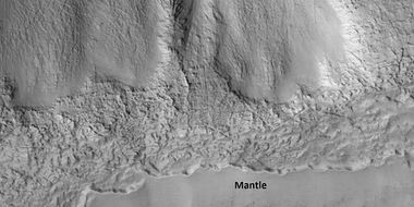
Much of the Martian surface is covered with a thick ice-rich, mantle layer that has fallen from the sky a number of times in the past.[29] [30] [31]
- 45085 2205mantlethickness.jpg
Close view of mantle Arrows show craters along edge which highlight the thickness of mantle.
Close view that displays the thickness of mantle.
- ESP 046444 2225flows.jpg
Mantle and flow A part of the image showing the mantle is enlarged in the next image.
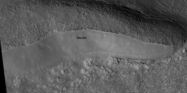
Mantle, as seen by HiRISE under HiWish program
- 51177 2230mantle.jpg
Close view of mantle
- 51230 2200mantle.jpg
Close view of mantle, as seen by HiRISE under HiWish program
- ESP 052774 2160mantleclosecolor.jpg
Color view of mantle Some parts of the image are covered with mantle; other parts are not.
- ESP 057480 2205mantlelayerstop.jpg
Mantle layers lying against steep slopes. Each layer represents a change in the climate of Mars.
- ESP 057480 2205pyramid.jpg
Mantle layers Mantle layers seem to be forming a group of dipping layers.


Climate change caused ice-rich features
Many features on Mars, especially ones found in the Ismenius Lacus quadrangle, are believed to contain large amounts of ice. The most popular model for the origin of the ice is climate change from large changes in the tilt of the planet's rotational axis. At times the tilt has even been greater than 80 degrees[32] [33] Large changes in the tilt explains many ice-rich features on Mars.
Studies have shown that when the tilt of Mars reaches 45 degrees from its current 25 degrees, ice is no longer stable at the poles.[34] Furthermore, at this high tilt, stores of solid carbon dioxide (dry ice) sublimate, thereby increasing the atmospheric pressure. This increased pressure allows more dust to be held in the atmosphere. Moisture in the atmosphere will fall as snow or as ice frozen onto dust grains. Calculations suggest this material will concentrate in the mid-latitudes, like those of the Ismenius Lacus quadrangle.[35] [36] General circulation models of the Martian atmosphere predict accumulations of ice-rich dust in the same areas where ice-rich features are found.[37] When the tilt begins to return to lower values, the ice sublimates (turns directly to a gas) and leaves behind a lag of dust.[38] [39] The lag deposit caps the underlying material so with each cycle of high tilt levels, some ice-rich mantle remains behind.[40] Note, that the smooth surface mantle layer probably represents only relative recent material.
Upper Plains Unit
Remnants of a 50–100 meter thick mantling, called the Upper Plains Unit, has been discovered in the mid-latitudes of Mars. First investigated in the Deuteronilus Mensae region, but it occurs in other places as well. The remnants consist of sets of dipping layers in craters and along mesas.[41] [42] Sets of dipping layers may be of various sizes and shapes—some look like Aztec pyramids from Central America.
- 47578 2245ctxP04 002481 2241.jpg
Wide view showing contact between upper plains unit lower part of picture and a lower unit, as seen by CTX
- ESP 047578 2245contact.jpg
Contact, as seen by HiRISE under HiWish program Upper plains unit on the left is breaking up. A lower unit exists on the right side of picture.
- 47578 2245contactclose.jpg
Close view of contact, as seen by HiRISE under HiWish program Picture shows details of how upper plains material is breaking. The formation of many fractures seems to proceed the break up.
- ESP 048870 2250contact.jpg
Wide view of upper plains unit eroding into hollows, as seen by HiRISE under HiWish program Parts of this image are enlarged in following images.
- 48870 2250contact.jpg
Close view of upper plain unit eroding into hollows, as seen by HiRISE under HiWish program Break up begins with cracks on the surface that expand as more and more ice disappears from the ground.
- 48870 2250contactclose.jpg
Close view of hollows, as seen by HiRISE under HiWish program
Associated with this unit are dipping layers. However, these groups of layers are found in many locations around the planet. They may be mostly caused by the build up and later erosion of layers of mantle. Mantle has been built up from many climate changes. These "dipping layers" occur mainly in protected spots--like inside craters or against the steep slope of a mesa or the walls of a depression.
- ESP 045613 2230pyramids.jpg
Wide view of dipping layers along mesa walls
- 45613 2230pyramids.jpg
Close view of dipping layers along a mesa wall, as seen by HiRISE under HiWish program
- ESP 035684 2160pyramidsbrains.jpg
Dipping layers, as seen by HiRISE under HiWish program
- ESP 036790 2200pyramids.jpg
Dipping layers in a crater, as seen by HiRISE under HiWish program
- P1010377redrocksfall.jpg
Layered feature in Red Rocks Park, Colorado. This has a different origin than ones on Mars, but it has a similar shape. Features in Red Rocks region were caused by uplift of mountains.
- 46180 2225brains.jpg
Close view of dipping layers, as seen by HiRISE under HiWish program Brain terrain is also visible in the image.
This unit also degrades into "brain terrain." Brain terrain is a region of maze-like ridges 3–5 meters high. Some ridges may consist of an ice core, so they may be sources of water for future colonists.
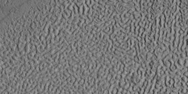
Brain terrain, as seen by HiRISE under HiWish program
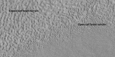
Open and closed brain terrain with labels, as seen by HiRISE under HiWish program
- ESP 042778 2225brain.jpg
Glacier surrounded by brain terrain, as seen by HiRISE under HiWish program
- ESP 042105 2235brainsforming.jpg
Brain terrain being formed from a thicker layer, as seen by HiRISE under HiWish program. Arrows show the thicker unit breaking up into small cells.
- 46075 2200brainsforming.jpg
Brain terrain being formed, as seen by HiRISE under HiWish program Arrows point to locations where the brain terrain is starting to form.
- 45349 2235brainsforming3.jpg
Brain terrain being formed, as seen by HiRISE under HiWish program Note: this is an enlargement of a previous image using HiView.
- 45349 2235brainsforming2.jpg
Brain terrain being formed, as seen by HiRISE under HiWish program Note: this is an enlargement of a previous image using HiView. Arrows indicate spots where brain terrain is beginning to form.
- ESP 045363 2190brain.jpg
Wide view of brain terrain being formed, as seen by HiRISE under HiWish program
- 46075 2200brainsside.jpg
Brain terrain with a view from the side, as seen by HiRISE under HiWish program Arrow shows where a side view of the brain terrain is visible.


Some regions of the upper plains unit display large fractures and troughs with raised rims; such regions are called ribbed upper plains. Fractures are believed to have started with small cracks from stresses. Stress is suggested to initiate the fracture process since ribbed upper plains are common when debris aprons come together or near the edge of debris aprons—such sites would generate compressional stresses. Cracks exposed more surfaces, and consequently more ice in the material sublimates into the planet's thin atmosphere. Eventually, small cracks become large canyons or troughs.

Well developed ribbed upper plains material. These start with small cracks that expand as ice sublimates from the surfaces of the crack. Picture was taken with HiRISE under HiWish program
- ESP 042765 2245cracks.jpg
Small and large cracks, as seen by HiRISE under HiWish program The small cracks to the left will enlarge to become much larger dues to sublimation of ground ice. A crack exposes more surface area, hence greatly increases sublimation in the thin Martian air.
- 42765 2245close.jpg
Close-up of canyons from previous image, as seen by HiRISE under HiWish program
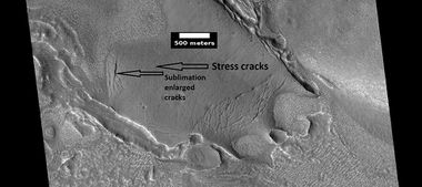
View of stress cracks and larger cracks that have been enlarged by sublimation (ice changing directly into gas) This may be the start of ribbed terrain.
- ESP 035011 2240pyramidshead.jpg
Dipping layers, as seen by HiRISE under HiWish program Also, Ribbed Upper plains material is visible in the upper right of the picture. It is forming from the upper plains unit, and in turn is being eroded into brain terrain.
- 45402 2230cracksmesas.jpg
Ribbed terrain being formed from upper plains unit, as seen by HiRISE under HiWish program Formation begins with cracks that enhance sublimation. Box shows the size of football field.
- 45837 2245turtles.jpg
Surface breaking down, as ice is removed, as seen by HiRISE under HiWish program Box shows size of football field.
- ESP 046365 2245ribbed.jpg
Wide view of terrain caused by ice leaving the ground, as seen by HiRISE under HiWish program
- ESP 046365 2245middle.jpg
Close view of terrain caused by ice leaving the ground, as seen by HiRISE under HiWish program
- ESP 046325 2225hollowa.jpg
Wide view of terrain caused by ice leaving the ground, as seen by HiRISE under HiWish program
Close view of terrain caused by ice leaving the ground, as seen by HiRISE under HiWish program Box shows size of football field.


Small cracks often contain small pits and chains of pits; these are thought to be from sublimation of ice in the ground.[43][44] Large areas of the Martian surface are loaded with ice that is protected by a meters thick layer of dust and other material. However, if cracks appear, a fresh surface will expose ice to the thin atmosphere.[45] [46] In a short time, the ice will disappear into the cold, thin atmosphere in a process called "sublimation." Dry ice behaves in a similar fashion on the Earth. On Mars sublimation has been observed when the Phoenix lander uncovered chunks of ice that disappeared in a few days.[47] [48] In addition, HiRISE has seen fresh craters with ice at the bottom. After a time, HiRISE saw the ice deposit disappear.[49]
- Ice sublimating in the Dodo-Goldilocks trench.gif
Die-sized clumps of bright material in the enlarged "Dodo-Goldilocks" trench vanished over the course of four days, implying that they were composed of ice which sublimated following exposure.[50]
- Evaporating ice on Mars Phoenix lander image.jpg
Color versions of the photos showing ice sublimation, with the lower left corner of the trench enlarged in the insets in the upper right of the images.
The upper plains unit is thought to have fallen from the sky. It drapes various surfaces, as if it fell evenly. As is the case for other mantle deposits, the upper plains unit has layers, is fine-grained, and is ice-rich. It is widespread; it does not seem to have a point source. The surface appearance of some regions of Mars is due to how this unit has degraded. It is a major cause of the surface appearance of lobate debris aprons.[44] The layering of the upper plains mantling unit and other mantling units are believed to be caused by major changes in the planet's climate. Models predict that the obliquity or tilt of the rotational axis has varied from its present 25 degrees to maybe over 80 degrees over geological time. Periods of high tilt will cause the ice in the polar caps to be redistributed and change the amount of dust in the atmosphere.[51] [52] [53]
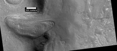
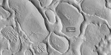
Pits and cracks
Some places in the Ismenius Lacus quadrangle display large numbers of cracks and pits. It is widely believed that these are the result of ground ice sublimating (changing directly from a solid to a gas). After the ice leaves, the ground collapses in the shape of pits and cracks. The pits may come first. When enough pits form, they unite to form cracks.[54]
- CTX Context Image of Pits.JPG
CTX Image in Protonilus Mensae, showing location of next image.
- Pits in Protonilus Mensae.JPG
Pits in Protonilus Mensae, as seen by HiRISE, under the HiWish program.
- Pits23314.jpg
Close-up of pits, as seen by HiRISE under the HiWish program. Resolution is about 30 cm, so one could see a kitchen table if it were in the picture.
- 49700 2250pitsclose.jpg
Close view of lines of pits, as seen by HiRISE, under the HiWish program Box shows size of football field. Pits may be up to around 50 meters across.
- 49700 2250polygons.jpg
Close view of pits and polygons, as seen by HiRISE, under the HiWish program Pits seem to occur in low spots between polygons.
- 52588 2210pits.jpg
Close view of pits, as seen by HiRISE, under the HiWish program
See also
- Dark slope streaks
- Geography of Mars
- High Resolution Imaging Science Experiment (HiRISE)
- HiWish program
- How are features on Mars Named?
- Glaciers on Mars
- Layers on Mars
- Mars Global Surveyor
- Rivers on Mars
References
- ↑ Carter | first1 = J. | last2 = Poulet | first2 = F. | last3 = Bibring | first3 = J.-P. | last4 = Murchie | first4 = S. | year = 2010 | title = Detection of Hydrated Silicates in Crustal Outcrops in the Northern Plains of Mars | url = | journal = Science | volume = 328 | issue = 5986| pages = 1682–1686 |
- ↑ Distances calculated using NASA World Wind measuring tool. http://worldwind.arc.nasa.gov/.
- ↑ http://planetarynames.wr.usgs.gov/SearchResults?target=MARS&featureType=Terra,%20terrae
- ↑ USGS Gazetteer of Planetary Nomenclature. Mars. http://planetarynames.wr.usgs.gov/.
- ↑ Blunck, J. 1982. Mars and its Satellites. Exposition Press. Smithtown, N.Y.
- ↑ http://www.uahirise.org/ESP_039997_2170
- ↑ U.S. department of the Interior U.S. Geological Survey, Topographic Map of the Eastern Region of Mars M 15M 0/270 2AT, 1991
- ↑ http://space.com/scienceastronomy/090514--mars-rivers.html
- ↑ https://en.wikipedia.org/wiki/Micrometre
- ↑ doi=10.1002/2017GL073821 | volume=44 | issue=11 | title=Extensive Amazonian-aged fluvial channels on Mars: Evaluating the role of Lyot crater in their formation | journal=Geophysical Research Letters | pages=5336–5344 | last1 = Weiss | first1 = David K.|
- ↑ Weiss, D., et al. 2017. Extensive Amazonian-aged fluvial channels on Mars: Evaluating the role of Lyot crater in their formation. Geophysical Research Letters: 44, doi:10.1002/2017GL073821.
- ↑ http://spaceref.com/mars/hot-rocks-led-to-relatively-recent-water-carved-valleys-on-mars.html
- ↑ http://www.lpi.usra.edu/publications/slidesets/stones/
- ↑ Template:Cite book
- ↑ http://www.uahirise.org/epo/nuggets/expanded-secondary.pdf
- ↑ Viola, D., et al. 2014. EXPANDED CRATERS IN ARCADIA PLANITIA: EVIDENCE FOR >20 MYR OLD SUBSURFACE ICE. Eighth International Conference on Mars (2014). 1022pdf.
- ↑ Irwin III, R. et al. 2005. An intense terminal epoch of widespread fluvial activity on early Mars: 2. Increased runoff and paleolake development. Journal of Geophysical Research: 10. E12S15
- ↑ Sharp, R. 1973. Mars Fretted and chaotic terrains. J. Geophys. Res.: 78. 4073–4083
- ↑ http://www.lpi.usra.edu/meetings/lpsc2000/pdf/1053.pdf
- ↑ Plaut, J. et al. 2008. Radar Evidence for Ice in Lobate Debris Aprons in the Mid-Northern Latitudes of Mars. Lunar and Planetary Science XXXIX. 2290.pdf
- ↑ Plaut | first1 = J. | last2 = Safaeinili | first2 = A. | last3 = Holt | first3 = J. | last4 = Phillips | first4 = R. | last5 = Head | first5 = J. | last6 = Seu | first6 = R. | last7 = Putzig | first7 = N. | last8 = Frigeri | first8 = A. | year = 2009 | title = Radar evidence for ice in lobate debris aprons in the midnorthern latitudes of Mars | url = https://semanticscholar.org/paper/f6b94761e6a276ce6894374ae9bea88fdc3e5e19%7C journal = Geophys. Res. Lett. | volume = 36| issue = 2| pages = n/a |
- ↑ Hugh H. Kieffer (1992). Mars. University of Arizona Press. ISBN 978-0-8165-1257-7
- ↑ Plaut, J. et al. 2008. Radar Evidence for Ice in Lobate Debris Aprons in the Mid-Northern Latitudes of Mars. Lunar and Planetary Science XXXIX. 2290.pdf
- ↑ http://www.esa.int/SPECIALS/Mars_Express/SEMBS5V681F_0.html
- ↑ http://news.discovery.com/space/mars-ice-sheet-climate.html
- ↑ Madeleine, J. et al. 2007. Exploring the northern mid-latitude glaciation with a general circulation model. In: Seventh International Conference on Mars. Abstract 3096.
- ↑ http://www.uahirise.org/ESP_018857_2225
- ↑ http://hirise.lpl.arizona.edu/PSP_009719_2230
- ↑ Hecht | first1 = M | year = 2002 | title = Metastability of water on Mars | url = | journal = Icarus | volume = 156 | issue = 2| pages = 373–386 | doi=10.1006/icar.2001.6794 |
- ↑ Mustard | first1 = J. |display-authors=etal | year = 2001 | title = Evidence for recent climate change on Mars from the identification of youthful near-surface ground ice | url = | journal = Nature | volume = 412 | issue = 6845| pages = 411–414 |
- ↑ Pollack | first1 = J. | last2 = Colburn | first2 = D. | last3 = Flaser | first3 = F. | last4 = Kahn | first4 = R. | last5 = Carson | first5 = C. | last6 = Pidek | first6 = D. | year = 1979 | title = Properties and effects of dust suspended in the martian atmosphere | url = | journal = J. Geophys. Res. | volume = 84 | issue = | pages = 2929–2945 | doi=10.1029/jb084ib06p02929 |
- ↑ Touma | first1 = J. | last2 = Wisdom | first2 = J. | year = 1993 | title = The Chaotic Obliquity of Mars | url = | journal = Science | volume = 259 | issue = 5099| pages = 1294–1297 |
- ↑ Laskar | first1 = J. | last2 = Correia | first2 = A. | last3 = Gastineau | first3 = M. | last4 = Joutel | first4 = F. | last5 = Levrard | first5 = B. | last6 = Robutel | first6 = P. | year = 2004 | title = Long term evolution and chaotic diffusion of the insolation quantities of Mars | url = | journal = Icarus | volume = 170 | issue = 2| pages = 343–364 |
- ↑ Levy | first1 = J. | last2 = Head | first2 = J. | last3 = Marchant | first3 = D. | last4 = Kowalewski | first4 = D. | year = 2008 | title = Identification of sublimation-type thermal contraction crack polygons at the proposed NASA Phoenix landing site: Implications for substrate properties and climate-driven morphological evolution | url = | journal = Geophys. Res. Lett. | volume = 35| issue = 4| pages = L04202 | doi = 10.1029/2007GL032813 |
- ↑ Levy | first1 = J. | last2 = Head | first2 = J. | last3 = Marchant | first3 = D. | year = 2009a | title = Thermal contraction crack polygons on Mars: Classification, distribution, and climate implications from HiRISE observations | url = | journal = J. Geophys. Res. | volume = 114| issue = E1| pages = E01007 | doi = 10.1029/2008JE003273 |
- ↑ Hauber, E., D. Reiss, M. Ulrich, F. Preusker, F. Trauthan, M. Zanetti, H. Hiesinger, R. Jaumann, L. Johansson, A. Johnsson, S. Van Gaselt, M. Olvmo. 2011. Landscape evolution in Martian mid-latitude regions: insights from analogous periglacial landforms in Svalbard. In: Balme, M., A. Bargery, C. Gallagher, S. Guta (eds). Martian Geomorphology. Geological Society, London. Special Publications: 356. 111–131
- ↑ Cite error: Invalid
<ref>tag; no text was provided for refs namedReferenceC - ↑ Mellon | first1 = M. | last2 = Jakosky | first2 = B. | year = 1995 | title = The distribution and behavior of Martian ground ice during past and present epochs | url = https://semanticscholar.org/paper/815bfd93bdb19325e03e08556d145fa470112e4e%7C journal = J. Geophys. Res. | volume = 100 | issue = E6| pages = 11781–11799 |
- ↑ Schorghofer | first1 = N | year = 2007 | title = Dynamics of ice ages on Mars | url = | journal = Nature | volume = 449 | issue = 7159| pages = 192–194 | doi=10.1038/nature06082| pmid = 17851518 |
- ↑ Madeleine, J., F. Forget, J. Head, B. Levrard, F. Montmessin. 2007. Exploring the northern mid-latitude glaciation with a general circulation model. In: Seventh International Conference on Mars. Abstract 3096.
- ↑ http://www.uahirise.org/ESP_048897_2125
- ↑ Carr | first1 = M | year = 2001 | title = Mars Global Surveyor observations of martian fretted terrain | url = | journal = J. Geophys. Res. | volume = 106 | issue = E10| pages = 23571–23593 | doi=10.1029/2000je001316 |
- ↑ Morgenstern, A., et al. 2007
- ↑ 44.0 44.1 Baker, D., J. Head. 2015. Extensive Middle Amazonian mantling of debris aprons and plains in Deuteronilus Mensae, Mars: Implication for the record of mid-latitude glaciation. Icarus: 260, 269–288.
- ↑ Mangold | first1 = N | year = 2003 | title = Geomorphic analysis of lobate debris aprons on Mars at Mars Orbiter Camera scale: Evidence for ice sublimation initiated by fractures | url = | journal = J. Geophys. Res. | volume = 108 | issue = E4| page = 8021 | doi=10.1029/2002je001885
- ↑ Levy, J. et al. 2009. Concentric
- ↑ http://www.nasa.gov/mission_pages/phoenix/news/phoenix-20080619.html Bright Chunks at Phoenix Lander's Mars Site Must Have Been Ice – Official NASA press release (19.06.2008)
- ↑ http://www.nasa.gov/mission_pages/phoenix/news/phoenix-20080619.html
- ↑ Byrne | first1 = S. |display-authors=etal | year = 2009 | title = Distribution of Mid-Latitude Ground Ice on Mars from New Impact Craters | url = | journal = Science | volume = 329 | issue = 5948| pages = 1674–1676 | doi = 10.1126/science.1175307 |
- ↑ Smith | first1 = P. |display-authors=etal | year = 2009 | title = H2O at the Phoenix Landing Site | url = | journal = Science | volume = 325 | issue = 5936| pages = 58–61 | doi = 10.1126/science.1172339 |
- ↑ Head, J. et al. 2003.
- ↑ Madeleine, et al. 2014.
- ↑ Schon |display-authors=etal | year = 2009 | title = A recent ice age on Mars: Evidence for climate oscillations from regional layering in mid-latitude mantling deposits | url = | journal = Geophys. Res. Lett. | volume = 36 | issue = 15| page = L15202 | bibcode = 2009GeoRL..3615202S|
- ↑ http://hirise.lpl.arizona.edu/PSP_009719_2230 |title=HiRISE | Fretted Terrain Valley Traverse (PSP_009719_2230) |publisher=Hirise.lpl.arizona.edu |


