Opportunity
Article written by Jim Secosky. Jim is a retired science teacher who has used the Hubble Space Telescope, the Mars Global Surveyor, and HiRISE.
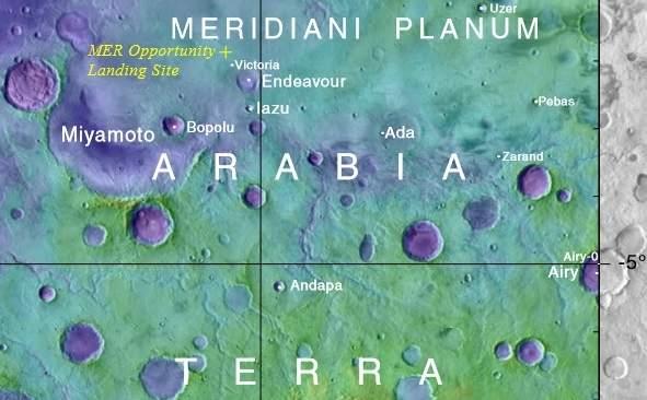
Opportunity was launched aboard a Delta II 7925H on July 7,2003; it landed on January 24, 2004 in Meridiani Planum in the Margaritifer Sinus quadrangle at 1.94 degrees S and 354.47 degrees E (5.53 W).[1] [2] [3] It’s last contact with Earth was on June 10, 2018. It is thought that its solar panels were not able to function because sunlight was cut off by planet-encircling dust storm, which was first detected May 30.[4] NASA declared the mission over in a press conference on February 13, 2019. It lasted almost 15 years.[5]
Map showing location of Opportunity and some nearby features
Contents
Spacecraft
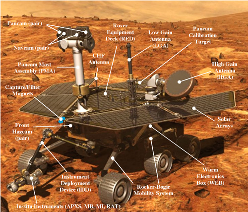
The Spirit and Opportunity Rovers were identical in construction. With a weight of 408 lbs. (185 kg), they are the size of a small car—1.5 meters tall, 2.3 meters wide, and 1.6 meters long.[6] [7]
Major parts of Opportunity
Nearly all power to operate the rover comes from solar panels that fold up to fit inside the lander for the trip to Mars, and deploy to form solar panels that have an area of 1.3 square meters (14 square feet) of three-layer photovoltaic cells. The 3 layers consist of gallium indium phosphorus, gallium arsenide and germanium. Almost 900 watt-hours of energy per Martian day, or sol can be produced by these cells. However, at times due to the accumulation of dust, change in season, or due to atmospheric conditions the energy production is greatly reduced. Lithium-ion batteries are also used. Besides using solar panels and batteries, Opportunity has eight radioisotope heaters to keep the craft warm during bitter cold nights (minus 157 degrees F). Producing about 1 watt of heat, each radioisotope heater holds about 2.7 grams (0.1 ounce) of plutonium dioxide as a pellet about the size and shape of the eraser on the end of a pencil. Each pellet is encapsulated in a covering of platinum-rhodium alloy and multiple layers of carbon-graphite composite material, making the whole unit about the size and shape of a C-cell battery. Heaters are expected to contain their plutonium dioxide in the event of an accident during launch. Other spacecraft, including Mars Pathfinder's Sojourner rover, have used radioisotope heater units to keep electronic systems warm.[8] Both Opportunity and Spirit Mars Exploration Rovers used an interesting method of getting to the Martian surface. They used the same kind of airbags that Mars Pathfinder used in 1997. To withstand the stresses of landing the airbags were made of a material called Vectran which has almost twice the strength as Kevlar. Three gas generators quickly inflated the four bags. All the bags were connected and crisscrossed with numerous ropes.[9] It was eventually determined that Opportunity bounced about 26 times and traveled about 300 meters before stopping in Eagle Crater.[10]
Instruments
- Panoramic Camera (Pancam)
- Microscopic Imager (MI)
- Hazcams
- Navcams
- Miniature Thermal Emission Spectrometer (Mini-TES)
- Mössbauer Spectrometer (MB)
- Alpha Particle X-Ray Spectrometer (APXS)
- Rock Abrasion Tool (RAT)
- Magnet Array
- Calibration targets ( including a sundial)[11]
Mission
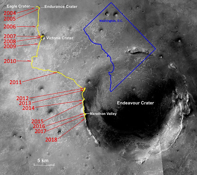
During over 14 years traveling on Mars, Opportunity traveled 45.16 Km. It was only designed to last 90 days. Thanks to dust devils which cleaned the solar panels many times, it received enough power to last years, instead of just a few months.[12] Many small and large Craters were visited by Opportunity including Eagle Crater (landed there), Endurance Crater, Victoria Crater, Fram Crater, Erebus Crater, and the massive EndeavourCrater.[13]
Path taken by Opportunity with years listed
Findings
Rock and mineral discoveries at Meridiani Planum
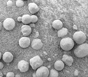
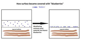
Observations from Opportunity Rover showed that the soil at Meridiani Planum was like the soil both at Gusev crater and at Ares Vallis; however, in many places at Meridiani the soil was covered with round, hard, gray spherules that were named "blueberries."[14] These blueberries were found to be composed almost entirely of the mineral hematite. It was decided that the blueberries generated the hematite spectra signal spotted from orbit by Mars Odyssey. That sign detected with Mars Odyssey was the reason this landing site was chosen, since hematite usually is produced in the presence of water. Further study revealed that the blueberries were concretions formed in the ground by water.[15] Eventually, these concretions weathered from what was overlying rock, and then became concentrated on the surface as a lag deposit. As little as one meter of rock could have produced the observed blueberry covering from weathering.[16] [17] Most of the soil consisted of olivine basalt sands that did not come from the local rocks. The sand was probably transported from somewhere else.[18]
Minerals in dust
A Mössbauer spectrum was made of the dust that gathered on Opportunity's capture magnet. The results suggested that the magnetic component of the dust was titanomagnetite, rather than just plain magnetite, as was previously thought. The spectrum also detected olivine which was interpreted as evidence of a long arid period. On the other hand, a small amount of hematite in the dust meant that there may have been liquid water for a short time in the early history of the planet.[19] One of the magnets was designed to prevent all magnetic dust from landing on it. Because no dust landed on it, scientists concluded that all dust in the atmosphere is magnetic.[20] Mini-TES was able to get a spectrum of a bright wind streak. The spectrum was a match for bright low-inertia dust that has been seen from orbit. [21] This information is consistent with the idea that bright wind streaks form from the deposition of airborne dust in the quiet air behind obstacles.[22]
Bedrock minerals
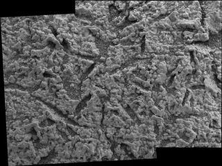
Few rocks were visible on the surface where Opportunity landed, but bedrock that was exposed in craters was examined by the suit of instruments on the Rover.[23] Because the Rock Abrasion Tool (RAT) found it easy to grind into the bedrocks, it is thought that the rocks are much softer than the rocks at Gusev crater. Bedrock rocks were characterized as sedimentary rocks with a high concentration of sulfur in the form of calcium and magnesium sulfates. Possible sulfates in bedrocks are kieserite, sulfate anhydrate, bassanite, hexahydrite, epsomite, and gypsum. Salts, such as halite, bischofite, antarcticite, bloedite, vanthoffite, or gluberite may also be present.[24] [25]
The rocks containing the sulfates had a light tone compared to isolated rocks and rocks examined by landers/rovers at other locations on Mars. The spectra of these light-toned rocks, containing hydrated sulfates, were similar to spectra taken by the Thermal Emission Spectrometer on board the Mars Global Surveyor. Since the same spectrum is found over a large area, it is supposed that water once appeared over a wide region, not just in the area explored by Opportunity Rover.[26] The Alpha Particle X-ray Spectrometer (APXS) found rather high levels of phosphorus in the rocks. Similar high levels were found by other rovers at Ares Vallis and Gusev Crater; thus, it has been hypothesized that the mantle of Mars may be phosphorus-rich.[27] Minerals in the rocks could have originated by acid weathering of basalt. If there were acid-rich fluids, it would be more difficult for life to have started here. [28] Because the solubility of phosphorus is related to the solubility of uranium, thorium, and rare earth elements, they are all also expected to be enriched in rocks.[29]
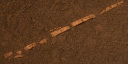
When Opportunity Rover traveled to the rim of Endeavour crater, it soon found a white vein that was later identified as being pure gypsum.[30] [31] This vein was formed when water carrying gypsum in solution deposited the mineral in a crack in the rock. A picture of this vein, called "Homestake" formation, is shown below.
Evidence for water
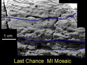
Examination of Meridiani rocks found strong evidence for past water. For instance, the mineral called jarosite which only forms in water was found in all bedrocks. This discovery proved that water once existed in Meridiani Planum.[32] In addition, some rocks showed small laminations (layers) with shapes that are only made by gently flowing water.[33] The first such laminations were found in a rock called "The Dells."[34] A picture of cross-stratification, also called cross-bedding, is shown on the left. Box-shaped holes in some rocks were caused by sulfates forming large crystals. When these sulfate crystals later dissolved, holes, called vugs, were left behind.[35] The concentration of the element bromine in rocks was highly variable probably because it is very soluble. Water may have concentrated it in places before it evaporated. [36]
Rock from impact
One rock, "Bounce Rock," found sitting on the sandy plains was found to be ejecta from an impact crater. Its chemistry was different than the bedrocks. Comprising mostly pyroxene and plagioclase and no olivine, it closely resembled a part, Lithology B, of the shergottite meteorite EETA 79001, a meteorite known to have come from Mars. Bounce rock received its name by being near an airbag bounce mark.[37] Since it’s chemical makeup was different than other rocks, researchers believe that it may have been thrown out by an impact some 75 Km away. It’s weak nature is also consistent with an impact origin. Bounce Rock may be what lies several kilometers beneath the surface.[38] Impacts are very useful to scientists since they can provide samples from deep in the ground.
Meteorites
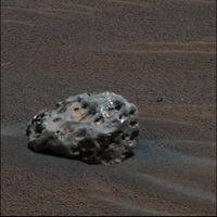
Opportunity Rover found meteorites just sitting on the plains. The first one analyzed with Opportunity's instruments was called "Heatshield Rock," as it was found near where Opportunity's headshield landed. Examination with the Miniature Thermal Emission Spectrometer (Mini-TES), Mossbauer spectrometer, and APXS lead researchers to state that it was similar to part of the Shergottite meteorite that is assumed to be from Mars.[39] [40] [41] The APXS determined it was composed of 93% iron and 7% nickel. The cobble named "Fig Tree Barberton" is thought to be a stony or stony-iron meteorite (mesosiderite silicate), [42] [43] while "Allan Hills," and "Zhong Shan" may be iron meteorites.
Geological history
Observations at the site have led scientists to believe that the area was flooded with water a number of times and was subjected to evaporation and desiccation. [44] In the process sulfates were deposited. After sulfates cemented the sediments, hematite concretions grew by precipitation from groundwater. Some sulfates formed into large crystals which later dissolved to leave vugs. Several lines of evidence point toward an arid climate in the past billion years or so, but a climate supporting water, at least for a time, in the distant past.[45] [46] Moreover, the high albedo (light-toned) materials near the landing site appear to be widespread; hence, a large region may have had a watery past.[47]
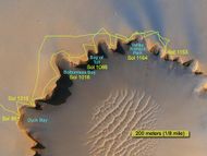
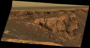
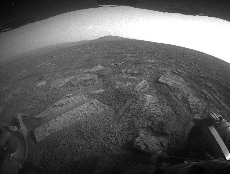
Botany Bay and Solander Point (in the distance)
References
- ↑ https://mars.nasa.gov/mer/mission/launch_e.html
- ↑ https://mars.nasa.gov/mer/overview/
- ↑ https://en.wikipedia.org/wiki/Margaritifer_Sinus_quadrangle
- ↑ https://mars.nasa.gov/news/8364/update-on-opportunity-rover-recovery-efforts/
- ↑ https://www.jpl.nasa.gov/news/news.php?feature=7334&utm_source=iContact&utm_medium=email&utm_campaign=nasajpl&utm_content=daily-20190213-4
- ↑ https://mars.jpl.nasa.gov/mer/mission/spacecraft.html
- ↑ http://science.answers.com/Q/What_is_the_size_of_Mars_Spirit_rover
- ↑ https://www.jpl.nasa.gov/news/press_kits/merlaunch.pdf
- ↑ https://www.youtube.com/watch?v=Vq25ZJwZJzU
- ↑ Soderblom, L., et al. 2004. Soils of Eagle Crater and Meridiani Planum at the Opportunity Rover Landing Site. Science: 306, 1723-1726.
- ↑ https://mars.jpl.nasa.gov/mer/mission/spacecraft_surface_instru.html
- ↑ https://mars.nasa.gov/mer/highlights/?page=0&per_page=3&order=publish_date+desc%2Ccreated_at+desc&search=&category=177&blank_scope=Latest
- ↑ https://en.wikipedia.org/wiki/Opportunity_(rover)
- ↑ Yen, A., et al. 2005. An integrated view of the chemistry and mineralogy of martian soils. Nature. 435.: 49-54.
- ↑ Bell, J (ed.) The Martian Surface. 2008. Cambridge University Press.
- ↑ Squyres, S. et al. 2004. The Opportunity Rover's Athena Science Investigation at Meridiani Planum, Mars. Science: 1698-1703.
- ↑ Soderblom, L., et al. 2004. Soils of Eagle Crater]and Meridiani Planum at the Opportunity Rover Landing Site. Science: 306. 1723-1726.
- ↑ Christensen, P., et al. Mineralogy at Meridiani Planum from the Mini-TES Experiment on the Opportunity Rover. Science: 306. 1733-1739.
- ↑ Goetz, W., et al. 2005. Indication of drier periods on Mars from the chemistry and mineralogy of atmospheric dust. Nature: 436.62-65.
- ↑ Goetz, W., et al. 2005. Indication of drier periods on mars from the chemistry and mineralogy of atmospheric dust. Nature: 436, 62-65.
- ↑ Bandfield, J., et al. 2003. Spectroscopic identification of carbonate minerals in the Martian dust. Science: 301, 1084-1087.
- ↑ Christensen, P., et al. 2004. Mineralogy at meridian Planum from the Mini-TES Experiment on the Opportunity Rover. Science: 306, 1733.
- ↑ Bell, J., et al. 2004. Pancam Multispectral Imaging Results from the Opportunity Rover at Meridiani Planum. Science: 306.1703-1708.
- ↑ Christensen, P., et al. 2004 Mineralogy at Meridiani Planum from the Mini-TES Experiment on the Opportunity Rover. Science: 306. 1733-1739.
- ↑ Squyres, S. et al. 2004. In Situ Evidence for an Ancient Aqueous Environment at Meridian Planum, Mars. Science: 306. 1709-1714.
- ↑ Hynek, B. 2004. Implications for hydrologic processes on Mars from extensive bedrock outcrops throughout Terra Meridiani. Nature: 431. 156-159.
- ↑ Dreibus,G. and H. Wanke. 1987. Volatiles on Earth and Marsw: a comparison. Icarus. 71:225-240
- ↑ Squyers, S., et al. 2004. In Situ Evidence for an Ancient Aqueous Environment at Meridiani Planum Mars. Science: 306, 1709-1714.
- ↑ Rieder, R., et al. 2004. Chemistry of Rocks and Soils at Meridiani Planum from the Alpha Particle X-ray Spectrometer. Science. 306. 1746-1749
- ↑ http://www.nasa.gov/mission_pages/mer/news/mer20111207.html
- ↑ https://www.sciencedaily.com/releases/2012/01/120125093619.htm
- ↑ Klingelhofer, G. et al. 2004. Jarosite and Hematite at Meridiani Planum from Opportunity's Mossbauer Spectrometer. Science: 306. 1740-1745.
- ↑ Herkenhoff, K., et al. 2004. Evidence from Opportunity's Microscopic Imager for Water on Meridian Planum. Science: 306. 1727-1730
- ↑ Squyres, S. et al. 2004. In Situ Evidence for an Ancient Aqueous Environment at Meridian Planum, Mars. Science: 306. 1709-1714.
- ↑ Herkenhoff, K., et al. 2004. Evidence from Opportunity's Microscopic Imager for Water on Meridian Planum. Science: 306. 1727-1730
- ↑ Yen, A., et al. 2005. An integrated view of the chemistry and mineralogy of martian soils. Nature. 435.: 49-54.
- ↑ Squyres, S. et al. 2004. In Situ Evidence for an Ancient Aqueous Environment at Meridian Planum, Mars. Science: 306. 1709-1714.
- ↑ Squyres, S., et al. 2004. The Opportunity Rover’s Athena Science Investigation at Meridiani Planum, Mars. Science: 306, 1698-1703.
- ↑ Squyers, S., et al. 2004. The Opportunity Rover’s Athena Science Investigation at Meridiani Planum, Mars. Science: 306, 1698-1709.
- ↑ McSween, et al. 1994. Meteoritics:29, 757.
- ↑ Christensen, P., et al. 2004. Mineralogy at Meridani Planum from the Mini-TES Experiment on the Opportunity Rover. Science: 306, 1733-1739.
- ↑ Squyres, S., et al. 2009. Exploration of Victoria Crater by the Mars Rover Opportunity. Science: 1058-1061.
- ↑ Schroder,C., et al. 2008. J. Geophys. Res.: 113.
- ↑ Squyres, S. et al. 2004. In Situ Evidence for an Ancient Aqueous Environment at Meridian Planum, Mars. Science: 306. 1709-1714.
- ↑ Clark, B. et al. Chemistry and mineralogy of outcrops at Meridiani Planum. Earth Planet. Sci. Lett. 240: 73-94.
- ↑ Salvatore, M., M. Kraft1, C. Edwards, P. Christensen. 2015. Geologic History of margaitifer Basin, Mars: Evidence for a Prolonged Yet Episodic Hydrologic System. 46th Lunar and Planetary Science Conference (2015) 1463.pdf
- ↑ Squyres, S. et al. 2004. In Situ Evidence for an Ancient Aqueous Environment at Meridian Planum, Mars. Science: 306. 1709-1714.
See Also
Recommended reading
- Squyers, S., et al. 2004. The Opportunity Rover’s Athena Science Investigation at Meridiani Planum, Mars. Science: 306, 1698-1709
- Opportunity Rover Press Kit
- Margaritifer_Sinus_quadrangle Wikipedia
- Six Things to Know About NASA's Opportunity Mars Rover
External links
- What did NASA's Opportunity Rover find on Mars? (Episode 2)
- NASA Extends Recovery Efforts for Opportunity as the Mars Rover Remains Silent After Dust Storm
- Mars Rover Opportunity Landing
- Mars Exploration Rover Opportunity Launch
Found substances
- Sulphur[1]

