Difference between revisions of "Lakes on Mars"
m (→External links) |
|||
| (58 intermediate revisions by 3 users not shown) | |||
| Line 1: | Line 1: | ||
| + | {{Mars atlas}} | ||
Lakes on Mars | Lakes on Mars | ||
Article written by Jim Secosky. Jim is a retired science teacher who has used the Hubble Space Telescope, the Mars Global Surveyor, and HiRISE. | Article written by Jim Secosky. Jim is a retired science teacher who has used the Hubble Space Telescope, the Mars Global Surveyor, and HiRISE. | ||
| − | It is believed that there were hundreds of lakes on Mars—over 200 | + | |
| + | It is believed that there were hundreds of lakes on Mars—over 200 inside of craters.<ref> | ||
| + | Fassett C. I. and Head J. W. 2008. Icarus. 195 61</ref> <ref>Goudge T. A., Aureli K. L., Head J. W., Fassett C. I. and Mustard J. F. 2015 Icarus. 260 346</ref> Water for the lakes came from various sources such as rainfall, runoff from surrounding land, melting of glaciers, and from groundwater [[sapping]].<ref>Benjamin D. Boatwright and James W. Head. 2021. Planet. Sci. J.Volume 2. Number 2. p. 52</ref> <ref>Salese F., Pondrelli M., Neeseman A., Schmidt G. and Ori G. G. 2019. JGRE. Vol. 124. P. 374</ref> | ||
| + | |||
| + | <gallery class="center" widths="380px" heights="360px"> | ||
| + | |||
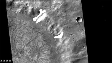
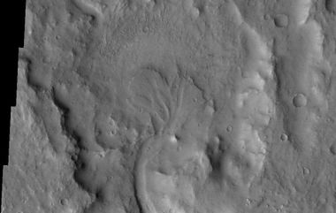
| + | File:B17 016128 1596glaciersmarssocietywithglaciersjpg.jpg|Crater with glaciers drawn in white. Glaciers were on walls. When they melted, channels took the water to the center of crater, and created a lake. The channels are now inverted. That is they formed ridges. | ||
| + | |||
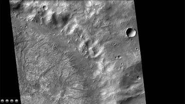
| + | File:B17 016128 1596glaciersmarssociety.jpg|Inverted channels on a crater floor. They run from where the glaciers were toward the center. | ||
| + | |||
| + | </gallery> | ||
| + | |||
| + | |||
| + | <gallery class="center" widths="380px" heights="360px"> | ||
| + | |||
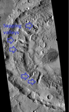
| + | File:J03 045825 2081sappingcraterarrowslabeled.jpg|Crater showing valleys that formed from sapping--that is the water flowed out of the ground. Eventually, the water formed a lake. | ||
| + | |||
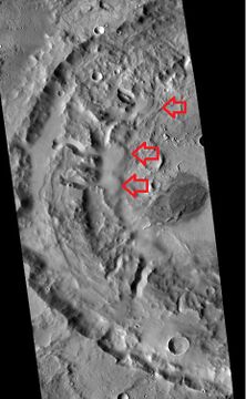
| + | File:J03 045825 2081sappingcraterdelta.jpg|Red arrows show deltas that formed from water that issued from the ground in sapping valleys. This is evidence that water came out of the ground and made a lake. | ||
| + | |||
| + | </gallery> | ||
One evidence for lakes is the presence of deltas in craters. Deltas form when water flows into a quiet body of water. | One evidence for lakes is the presence of deltas in craters. Deltas form when water flows into a quiet body of water. | ||
==Images of possible deltas== | ==Images of possible deltas== | ||
| − | <gallery class="center" widths=" | + | |
| + | <gallery class="center" widths="380px" heights="360px"> | ||
Image:Delta in Margaritifer Sinus.jpg|Possible delta in [[Margaritifer Sinus quadrangle]] as seen by THEMIS. | Image:Delta in Margaritifer Sinus.jpg|Possible delta in [[Margaritifer Sinus quadrangle]] as seen by THEMIS. | ||
| Line 12: | Line 33: | ||
Image:Delta in Lunae Palus.jpg|Delta in [[Lunae Palus quadrangle]], as seen by THEMIS. | Image:Delta in Lunae Palus.jpg|Delta in [[Lunae Palus quadrangle]], as seen by THEMIS. | ||
Image:Delta as seen by HiRISE.jpg|Delta that fills a crater in [[Lunae Palus quadrangle]], as seen by HiRISE. | Image:Delta as seen by HiRISE.jpg|Delta that fills a crater in [[Lunae Palus quadrangle]], as seen by HiRISE. | ||
| − | Image:605555-PIA15097-JezeroCrater-Delta.jpg|[[Jezero | + | Image:605555-PIA15097-JezeroCrater-Delta.jpg|[[Jezero Crater]] delta - chemical alteration by water ([[:File:260184-JezeroCrater-Delta-Full.jpg|hi-res]]) |
</gallery> | </gallery> | ||
| − | Some places that are believed to have once held lakes are Holden Crater, [[Jezero Crater]], [[Gale Crater]], Ritchey Crater, Columbus | + | Some places that are believed to have once held lakes are [[Holden Crater]], [[Jezero Crater]], [[Gale Crater]], [[Ritchey Crater]], [[Columbus Crater]], [[Valles Marineris]], Argyre basin, Hellas Basin, and large areas in Eridania. |
| + | |||
| + | <gallery class="center" widths="380px" heights="360px"> | ||
| + | |||
| + | |||
| + | File:Martian impact crater Holden based on day THEMIS.png|Holden Crater, as seen by THEMIS | ||
| + | |||
| + | File:Martian crater Columbus based on day THEMIS.png|[[Columbus Crater]] | ||
| + | |||
| + | |||
| + | [[File:Martian impact crater Holden based on day THEMIS.png]]|[[Holden Crater]], as seen by THEMIS. Image is located in the [[Margaritifer Sinus quadrangle]]. | ||
| − | |||
| − | |||
</gallery> | </gallery> | ||
| − | <gallery class="center" widths=" | + | |
| − | Image: | + | <gallery class="center" widths="380px" heights="360px"> |
| + | |||
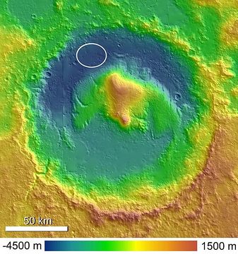
| + | Image:Topographic Map of Gale Crater.jpg|Gale Crater with Aeolis Mons rising from the center. The noted [[Curiosity]] landing area is near Peace Vallis in Aeolis Palus. Curiosity landed in the northern part of the crater. | ||
| + | |||
</gallery> | </gallery> | ||
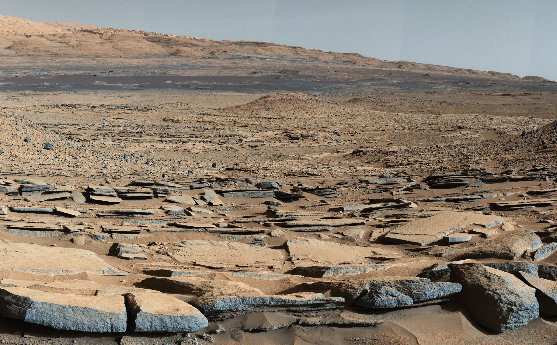
| − | [[File: | + | [[File:7505 mars-curiosity-rover-gale-crater-beauty-shot-pia19839-full2.jpg|600pxr|View from the "Kimberley" formation on Mars taken by NASA's Curiosity rover.]] |
| + | |||
| + | View from the "Kimberley" formation on Mars taken by NASA's Curiosity rover. Layered rock formed under lake. | ||
| + | |||
| + | |||
| − | |||
| − | <gallery class="center" widths=" | + | <gallery class="center" widths="380px" heights="360px"> |
PIA22059 fig1eridaniadepths.jpg|Map showing estimated water depth in different parts of Eridania Sea This map is about 530 miles across. | PIA22059 fig1eridaniadepths.jpg|Map showing estimated water depth in different parts of Eridania Sea This map is about 530 miles across. | ||
| Line 36: | Line 71: | ||
Another major form of evidence is the finding of minerals such as clays, carbonates, and sulfates. These minerals require water to be produced. These minerals were both detected from orbit and from rovers on the surface of Mars. The Curiosity Rover has been exploring Gale crater for years with very sophisticated instruments. Many of the minerals identified were hydrated which required water. Some of these hydrated minerals are actinolite, montmorillonite, saponite, jarosite, halloysite, szomolnokite and magnesite. In some places 40 vol% of the minerals were hydrous minerals. <ref>Lin H.; et al. (2016). "Abundance retrieval of hydrous minerals around the Mars Science Laboratory landing site in Gale crater, Mars". Planetary and Space Science. 121: 76–82.</ref> | Another major form of evidence is the finding of minerals such as clays, carbonates, and sulfates. These minerals require water to be produced. These minerals were both detected from orbit and from rovers on the surface of Mars. The Curiosity Rover has been exploring Gale crater for years with very sophisticated instruments. Many of the minerals identified were hydrated which required water. Some of these hydrated minerals are actinolite, montmorillonite, saponite, jarosite, halloysite, szomolnokite and magnesite. In some places 40 vol% of the minerals were hydrous minerals. <ref>Lin H.; et al. (2016). "Abundance retrieval of hydrous minerals around the Mars Science Laboratory landing site in Gale crater, Mars". Planetary and Space Science. 121: 76–82.</ref> | ||
| + | |||
| + | == Underground Lakes Near the South Pole == | ||
| + | Deep penetrating radar detected several possible lakes of liquid water (or brine) under the polar cap near the South Pole. It was thought that these were kept liquid by geothermal heat. However, modelling suggested that they should freeze. Currently the theory is that they are not lakes at all, but bands of clay material. Under the right amount of pressure, they would give a radar return like water.<ref>https://www.scientificamerican.com/article/buried-lakes-on-mars-may-just-be-frozen-clay/</ref> | ||
==See also== | ==See also== | ||
| + | *[[Aeolis quadrangle]] | ||
| + | *[[Columbus Crater]] | ||
*[[Curiosity]] | *[[Curiosity]] | ||
| + | *[[High Resolution Imaging Science Experiment (HiRISE)]] | ||
| + | *[[Holden Crater]] | ||
| + | *[[Jezero Crater]] | ||
| + | *[[Margaritifer Sinus quadrangle]] | ||
*[[Spirit]] | *[[Spirit]] | ||
| − | |||
==References== | ==References== | ||
{{Reflist|30em}} | {{Reflist|30em}} | ||
| + | |||
| + | |||
| + | == External links == | ||
| + | |||
| + | *Head, J., et al. 2023. GEOLOGICAL AND CLIMATE HISTORY OF MARS: IDENTIFICATION OF POTENTIAL WARM AND | ||
| + | WET CLIMATE ‘FALSE POSITIVES’. 54th Lunar and Planetary Science Conference 2023 (LPI Contrib. No. 2806). 1731.pdf | ||
| + | |||
| + | * https://mail.google.com/mail/u/0/?tab=wm&pli=1#inbox/FMfcgzGrbHtSWzJjdRzftxgXCrbxXNnK Water on Mars - A Literature Review" by Mohammad Nazari-Sharabian | ||
| + | |||
| + | * [https://www.youtube.com/watch?v=D-SCOHj8u-A Water on Mars - James Secosky - 2021 Mars Society Virtual Convention -- Tells where water was and where ice is today on Mars (34 minutes)] | ||
| + | |||
| + | * [https://en.wikipedia.org/wiki/Lakes_on_Mars Lakes on Mars] | ||
| + | |||
| + | * [https://www.youtube.com/watch?v=9rbnvdWk3eg The Lakes and Rivers of Ancient Mars] | ||
| + | * [https://www.youtube.com/watch?v=DGBbke1wJRk Lakes on Mars - Nathalie Cabrol (SETI Talks)] | ||
| + | |||
| + | * [https://www.youtube.com/watch?v=a4UiwmbrI3o Researchers discover a new type of crater lake on Mars' surface] | ||
| + | |||
| + | * [https://www.youtube.com/watch?v=QWcdAvFN_q0 James Wray - The Search for Water and Life on Mars (and Beyond) (November 15, 2018)] | ||
| + | *[https://www.youtube.com/watch?v=b4hCWIQsyps Mars: Ancient Water, Present Day Ice] | ||
| + | |||
| + | * [https://www.youtube.com/watch?v=bs8wTdCJ-NA What Happened To All The Water On Mars?] | ||
| + | *[https://www.youtube.com/watch?v=EJk0hS4_gz4 Water on Mars and the Potential for Martian Life] | ||
| + | * [https://www.youtube.com/watch?v=d-27kmtkrog Advances in the Mineralogy of Mars] | ||
| + | * [https://www.youtube.com/watch?v=K5tbrf9TNak Mars Crater Modification in the Late Noachian:] | ||
| + | |||
| + | * [https://www.youtube.com/watch?v=NiT02piO40c The Geological History of Water on Mars and Astrobiological Implications (Vic Baker)] | ||
| + | * [https://www.youtube.com/watch?v=wI183V7evbg Seeking Signs of Ancient Life in Jezero Crater with the Mars 2020 Perseverance Rover 103 minutes] | ||
Latest revision as of 15:21, 20 March 2023
Lakes on Mars Article written by Jim Secosky. Jim is a retired science teacher who has used the Hubble Space Telescope, the Mars Global Surveyor, and HiRISE.
It is believed that there were hundreds of lakes on Mars—over 200 inside of craters.[1] [2] Water for the lakes came from various sources such as rainfall, runoff from surrounding land, melting of glaciers, and from groundwater sapping.[3] [4]
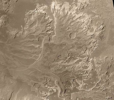
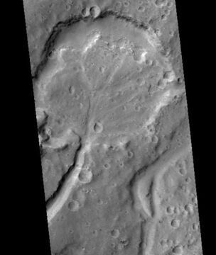
One evidence for lakes is the presence of deltas in craters. Deltas form when water flows into a quiet body of water.
Contents
Images of possible deltas
Possible delta in Margaritifer Sinus quadrangle as seen by THEMIS.
Probable delta in Eberswalde Crater that lies to the NE of Holden Crater, as seen by Mars Global Surveyor. Image in Margaritifer Sinus quadrangle.
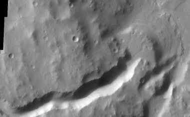
Delta in Lunae Palus quadrangle, as seen by THEMIS.
Delta that fills a crater in Lunae Palus quadrangle, as seen by HiRISE.
Jezero Crater delta - chemical alteration by water (hi-res)
Some places that are believed to have once held lakes are Holden Crater, Jezero Crater, Gale Crater, Ritchey Crater, Columbus Crater, Valles Marineris, Argyre basin, Hellas Basin, and large areas in Eridania.
Gale Crater with Aeolis Mons rising from the center. The noted Curiosity landing area is near Peace Vallis in Aeolis Palus. Curiosity landed in the northern part of the crater.
View from the "Kimberley" formation on Mars taken by NASA's Curiosity rover. Layered rock formed under lake.
Another major form of evidence is the finding of minerals such as clays, carbonates, and sulfates. These minerals require water to be produced. These minerals were both detected from orbit and from rovers on the surface of Mars. The Curiosity Rover has been exploring Gale crater for years with very sophisticated instruments. Many of the minerals identified were hydrated which required water. Some of these hydrated minerals are actinolite, montmorillonite, saponite, jarosite, halloysite, szomolnokite and magnesite. In some places 40 vol% of the minerals were hydrous minerals. [5]
Underground Lakes Near the South Pole
Deep penetrating radar detected several possible lakes of liquid water (or brine) under the polar cap near the South Pole. It was thought that these were kept liquid by geothermal heat. However, modelling suggested that they should freeze. Currently the theory is that they are not lakes at all, but bands of clay material. Under the right amount of pressure, they would give a radar return like water.[6]
See also
- Aeolis quadrangle
- Columbus Crater
- Curiosity
- High Resolution Imaging Science Experiment (HiRISE)
- Holden Crater
- Jezero Crater
- Margaritifer Sinus quadrangle
- Spirit
References
- ↑ Fassett C. I. and Head J. W. 2008. Icarus. 195 61
- ↑ Goudge T. A., Aureli K. L., Head J. W., Fassett C. I. and Mustard J. F. 2015 Icarus. 260 346
- ↑ Benjamin D. Boatwright and James W. Head. 2021. Planet. Sci. J.Volume 2. Number 2. p. 52
- ↑ Salese F., Pondrelli M., Neeseman A., Schmidt G. and Ori G. G. 2019. JGRE. Vol. 124. P. 374
- ↑ Lin H.; et al. (2016). "Abundance retrieval of hydrous minerals around the Mars Science Laboratory landing site in Gale crater, Mars". Planetary and Space Science. 121: 76–82.
- ↑ https://www.scientificamerican.com/article/buried-lakes-on-mars-may-just-be-frozen-clay/
External links
- Head, J., et al. 2023. GEOLOGICAL AND CLIMATE HISTORY OF MARS: IDENTIFICATION OF POTENTIAL WARM AND
WET CLIMATE ‘FALSE POSITIVES’. 54th Lunar and Planetary Science Conference 2023 (LPI Contrib. No. 2806). 1731.pdf
- https://mail.google.com/mail/u/0/?tab=wm&pli=1#inbox/FMfcgzGrbHtSWzJjdRzftxgXCrbxXNnK Water on Mars - A Literature Review" by Mohammad Nazari-Sharabian
- James Wray - The Search for Water and Life on Mars (and Beyond) (November 15, 2018)
- Mars: Ancient Water, Present Day Ice
