Amenthes quadrangle

| MC-14 | Amenthes | 0–30° N | 90–135° E | Quadrangles | Atlas |


In this article, some of the best pictures from a number of spacecraft will show what the landscape looks like in this region. The origins and significance of all features will be explained as they are currently understood.
The Amenthes quadrangle contains features with names like Isidis, Amenthes Fossae, Libya Montes, and Escalente Crater. Nearly all the names of Martian locations are from old writings like the Bible and Homer. Early astronomers gave names to things they saw on Mars. Things were given names and then other names, over and over. Finally the astronomer Giovanni Schiaparelli, after making drawings when Mars was exceptionally close in 1887, assigned the names still in use today, over a hundred years later.[1] [2] Giovanni Schiaparelli is called the Father of Mars—at one point he knew more about Mars than any other living person. The name Amenthes is the Egyptian word for the place where the souls of the dead go.[3]

Scenes of the Amenthes quadrangle
Location
The Amenthes quadrangle covers the area from 0° to 30° north latitude and 225° to 270° west longitude (135-90 E). Amenthes quadrangle contains parts of Utopia Planitia, Isidis Planitia, Terra Cimmeria, and Tyrrhena Terra. There are different ways of telling positions on Mars. One can just give coordinates. One can use one of the maps that have been produced form old drawings dating back to Schiaparelli--this is usually done. Here we are going by a system where the surface of Mars is divided into 30 regions, called quadrangles. Nearly all of the quadrangles use the classical names. So, Amenthes quadrangle is one of a series of 30 quadrangle maps of Mars used by the United States Geological Survey (USGS). The Amenthes quadrangle is also referred to as MC-14 (Mars Chart-14).[4]
Significant facts
The Amenthes quadrangle contains several features commonplace on Mars. It has dark slope streaks, troughs (fossae), and river valleys (Vallis {word used in planetary geology}) in this quadrangle. This quadrangle contains the Isidis basin, a location where magnesium carbonate was found by Mars Reconnaissance Orbiter. This mineral indicates that water was present and that it was not acidic. This fact increases the chances of life here in the past. Although some organisms can live in an acid environment, most living things do not thrive in an acid environment. The Beagle 2 lander was about to land in the quadrangle, particularly in the eastern part of Isidis Planitia, in December 2003, when contact with the craft was lost. In January 2015, NASA reported the Beagle 2 had been found on the surface in Isidis Planitia (location is about 11.5265 N and 90.4295 E.[5] [6] High-resolution images captured by the Mars Reconnaissance Orbiter identified the lost probe, which appears to be intact.[7] [8] [9]
Craters


Some craters in the Amenthes region (as well as other parts of Mars) show ejecta around them that have lobes. It is believed that the lobed shape is caused by an impact into water or ice logged ground. Calculations suggest that ice is stable beneath the Martian surface; hence, it is reasonable to think that some asteroids slammed into ice-rich ground. Great amounts of heat are produced during impacts. The area around a large impact may take hundreds of thousands of years to cool. Some ejecta show small channels that may have formed from hot ejecta. [10][11]
At the equator a stable layer of ice might lie under as much as 1 kilometer of material, but at higher latitudes the ice may be just a few centimeters below the surface. This was proven when the landing rockets on the Phoenix lander blew away surface dust to reveal an ice surface.[12] [13] The larger an impact crater, the deeper its penetration, a large crater is more likely to have a lobate ejecta since it went down to the ice layer. When even small craters have lobes, the ice level is close to the surface.[14] This idea would be very important for future colonists on Mars who would like to live near a source of water.
-
 Lobate ejecta in Amenthes. Large crater has lobate ejecta, smaller craters do not show such ejecta since the ice layer was not penetrated by the smaller impacts. Such lobate ejecta are accepted as an impact occurring into ice rich ground. There are more of these where there is more ice in the ground--especially in colder places nearer to the poles. The box show the location of a picture that was taken in high resolution with the Mars Global Surveyor.

Impact craters generally have a rim with ejecta around them, in contrast volcanic craters usually do not have a rim or ejecta deposits.[15] Sometimes craters will display layers. Since the collision that produces a crater is like a powerful explosion, rocks from deep underground are tossed unto the surface. Hence, craters can show us what lies deep under the surface.
One crater in the Amenthes quadrangle is believed to be a source of nakhlite meteorites. A team of researchers found that these particular meteorites came from four different eruptions of lava because they showed different ages. The ages were measured by comparing isotopes of the element Argon. Since the ages vary from 93 to 1322 million years, the authors concluded that volcanoes grow much more slowly on Mars than the Earth. The wide range of ages mean that Martian volcanoes erupt off and on for a long, long time. Many of the volcanoes on the Earth grow much quicker, as they form at plate boundaries. In contrast, Martian volcanoes probably form from plumes.[16]

Hebrus Valles
Hebrus Vales has tributaries, terraces, and teardrop shaped islands. The teardrop shape of the islands tells us what direction the water used to flow. The terraces may be caused by different layers of rocks or from the water being at different levels in the past. Often, the water level in places changes. For example, if the water flows at a high level for a time, it will create a terrace or beach at that level. And then later, if the level drops, a new terrace will be made.[17] These features are common for the rivers of the Earth.
The Hebrus Valles region has been suggested to have Karst caves. They may be like the caverns of Earth. Such caves are formed by ancient water dissolving carbonate and sulfate rocks. Researchers have found eight possible cave openings, or "skylights.” This discovery of water-carved caves is a significant finding because life may exist there since it would be protected from the harsh surface environment. In addition, future colonists may be able to live in them. Karstic caves were formed when water flowed underground and dissolved carbonate and sulfate rocks. The process created tunnels and chambers. When the roofs of these cavities collapsed skylight entrances became visible from orbit. The Thermal Emission Spectrometer (TES) discovered that the rock surrounding the cave entrances is rich in carbonates and sulfates. These minerals are easily dissolved by water. There is also much evidence that water flowed in the Hebrus Valles region. It contains tributaries, terraces, and teardrop-shaped islands that are formed by running water. [18] [19]
-
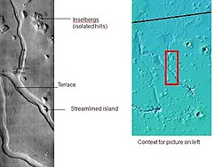 Hebrus Valles, as seen by THEMIS. Direction of flow was determined by shape of streamlined islands. Terraces may have been due to separate flood events.

Streamlined shapes

Streamlined shapes are formed from erosion by flowing water. Hence, when we see such shapes we know running water was involved. Mars shows many signs all over its surface that it once had much water. Based on the evidence of all these signs of past water, scientists believe that there is a good chance that life arose and thrived early in its history. Interestingly to consider is the possibility that life first began on Mars and then was later transported to the Earth by low angle impacts of asteroids. Many, many meteoites have been found that have been proven to have originated on Mars. Experiments have shown that organisms could survive the journey. So, many of our genes (DNA) may be of Martian origin. If we find chemical evidence of life on Mars, maybe after just a few months of study we will know whether we our decedents of Martian organisms.

-
 Close view of streamlined shapes
 -
 Close view of streamlined shapes
 -
 Streamline features
 -
 Streamlined features as seen by HiRISE under HiWish program


Streamlined shapes from rushing flood waters
Cones

Cones can have their origin from volcanic methods or from the movement of mud. When a layer of mud is covered over, it may become pressurized and move up, erupting into what we call “mud volcanoes.” They are common in some areas of Mars. Cones seen in the Amenthes quadrangle are probably mud volcanoes. The pictures in this section show some of the cones found in Amenthes.


-
 Line of cones
 -
 Close view of cones, as seen by HiRISE under HiWish program


Mesas
Mesas form when erosion has removed much of the surrounding ground. They are the remains of material that once covered a wide area.
-
 Layered mesa that appears to have a streamlined shape, as seen by HiRISE under HiWish program A channel has cut through a lower layer.
 -
 Layered mesa


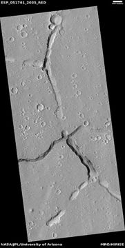
Fossae
The Amenthes quadrangle is also home to troughs (long narrow depressions) called fossae in the geographical language used for Mars. These troughs form when the crust is stretched until it breaks. The stretching can be due to the large weight of a nearby volcano of which Mars has plenty.
-
 Large pits
 -
 Trough
 -
 Troughs
 -
 Troughs cutting through mesa, as seen by HiRISE under HiWish program


Channels

See also
- Dark slope streaks
- Geography of Mars
- High Resolution Imaging Science Experiment (HiRISE)
- HiWish program
- How are features on Mars Named?
- Mars Global Surveyor
- Rivers on Mars
References:
- ↑ Macdonald, T. 1971. The origins of Martian Nomenclature. Icarus: 15, 233-240.
- ↑ Glasstone, S. 1968. The Book of Mars. NASA. Washington, D.C
- ↑ Blunck, J. 1982. Mars and its Satellites. Exposition Press. Smithtown, N.Y.
- ↑ Davies, M.E.; Batson, R.M.; Wu, S.S.C. “Geodesy and Cartography” in Kieffer, H.H.; Jakosky, B.M.; Snyder, C.W.; Matthews, M.S., Eds. Mars. University of Arizona Press: Tucson, 1992.
- ↑ {{cite web |last=Ellison |first=Doug |title=re Beagle 2 location on Mars => "Using HiView on image ESP_039308_1915_COLOR.JP2 I get 90.4295E 11.5265N" |url=https://twitter.com/doug_ellison/status/556201983443357696 |date=16 January 2015 |work=Twitter & JPL |
- ↑ Grecicius |first1=Tony |last2=Dunbar |first2=Brian |title=Components of Beagle 2 Flight System on Mars |url=http://www.nasa.gov/jpl/mars/pia19106/ |date=16 January 2015 |work=NASA
- ↑ Webster |first=Guy |title='Lost' 2003 Mars Lander Found by Mars Reconnaissance Orbiter |url=http://www.nasa.gov/jpl/lost-2003-mars-lander-found-by-mars-reconnaissance-orbiter/ |date=16 January 2015 |work=NASA |
- ↑ https://www.nytimes.com/2015/01/17/science/space/missing-lander-beagle-2-finally-located-on-mars.html |date=16 January 2015 |work=The New York Times
- ↑ Amos |first=Jonathan |title=Lost Beagle2 probe found 'intact' on Mars |url=https://www.bbc.co.uk/news/science-environment-30784886 |date=16 January 2015 |work=BBC
- ↑ Segura, T, O. Toon, A. Colaprete, K. Zahnle. 2001. Effects of Large Impacts on Mars: Implications for River Formation. American Astronomical Society, DPS meeting#33, #19.08
- ↑ Segura, T, O. Toon, A. Colaprete, K. Zahnle. 2002. Environmental Effects of Large Impacts on Mars. Science: 298, 1977-1980.
- ↑ http://www.nasa.gov/mission_pages/phoenix/news/phoenix-20080531.html
- ↑ http://www.nasa.gov/centers/ames/news/releases/2008/08_108AR_prt.html
- ↑ http://sci.esa.int/science-e/www/object/index.cfm?fobjectid=31026
- ↑ Kieffer|title=Mars|url=https://books.google.com/books?id=NoDvAAAAMAAJ%7Caccessdate=7 March 2011|date=1992|publisher=University of Arizona Press|isbn=978-0-8165-1257-7
- ↑ Cohen, B., et al. 2017. Taking the pulse of Mars via dating of a plume-fed volcano. Nature Communications. 8, 640.
- ↑ http://themis.asu.edu/zoom-20020603a
- ↑ https://universemagazine.com/en/place-of-life-scientists-find-water-formed-caves-on-mars/#:~:text=The%20caves%20we%20are%20talking,science%20communicator%2C%20author
- ↑ Sharma, R. 2025. Water-driven Accessible Potential Karstic Caves in Hebrus Valles, Mars: Implications for Subsurface Habitability. The Astrophysical Journal Letters, 993:L36 (13pp), 2025 November 1.