Difference between revisions of "Phaethontis quadrangle"
m |
m |
||
| Line 30: | Line 30: | ||
Image:Gorgonum in Phaethontis.JPG|[[Gorgonum Chaos]] as seen by [[Mars Reconnaissance Orbiter]] [[HiRISE]]. Image about 4 km wide. | Image:Gorgonum in Phaethontis.JPG|[[Gorgonum Chaos]] as seen by [[Mars Reconnaissance Orbiter]] [[HiRISE]]. Image about 4 km wide. | ||
Image:Gully in Phaethontis.jpg|Group of gullies on north wall of crater that lies west of the crater Newton (41.3047 degrees south latitude, 192.89 east longitide). Image taken with [[Mars Global Surveyor]] under the [[MOC Public Targeting Program]]. | Image:Gully in Phaethontis.jpg|Group of gullies on north wall of crater that lies west of the crater Newton (41.3047 degrees south latitude, 192.89 east longitide). Image taken with [[Mars Global Surveyor]] under the [[MOC Public Targeting Program]]. | ||
| − | + | ||
| − | + | ||
| − | + | ||
| − | + | ||
| − | |||
Image:Wide view of gully on hill.JPG|CTX image of the next image showing a wide view of the area. Since the hill is isolated it would be difficult for an aquifer to develop. Rectangle shows the approximate location of the next image. | Image:Wide view of gully on hill.JPG|CTX image of the next image showing a wide view of the area. Since the hill is isolated it would be difficult for an aquifer to develop. Rectangle shows the approximate location of the next image. | ||
Image:Gully on mound.JPG|Gully on mound as seen by [[Mars Global Surveyor]], under the [[MOC Public Targeting Program]]. Images of gullies on isolated peaks, like this one, are difficult to explain with the theory of water coming from aquifers because aquifers need large collecting areas. | Image:Gully on mound.JPG|Gully on mound as seen by [[Mars Global Surveyor]], under the [[MOC Public Targeting Program]]. Images of gullies on isolated peaks, like this one, are difficult to explain with the theory of water coming from aquifers because aquifers need large collecting areas. | ||
| + | |||
Image:28386myglaciers.jpg|Another view of the previous gully on a mound. This one is with HiRISE, under the [[HiWish program]]. This view shows most of the apron and two old glaciers associated with it. All that is left of the glaciers are terminal moraines. | Image:28386myglaciers.jpg|Another view of the previous gully on a mound. This one is with HiRISE, under the [[HiWish program]]. This view shows most of the apron and two old glaciers associated with it. All that is left of the glaciers are terminal moraines. | ||
| + | |||
Image:Context image for gullies in crater and trough.JPG|MOLA context image for the series of three images to follow of gullies in a trough and nearby crater. | Image:Context image for gullies in crater and trough.JPG|MOLA context image for the series of three images to follow of gullies in a trough and nearby crater. | ||
| − | + | ||
Image:Gullies in crater under HiWish.JPG|Close-up of gullies in crater, as seen by HiRISE under the HiWish program. | Image:Gullies in crater under HiWish.JPG|Close-up of gullies in crater, as seen by HiRISE under the HiWish program. | ||
| − | + | ||
Image:ESP_020012gulliescropped.jpg|Gullies near Newton Crater, as seen by HiRISE, under the [[HiWish program]]. Place where there was an old glacier is labeled. | Image:ESP_020012gulliescropped.jpg|Gullies near Newton Crater, as seen by HiRISE, under the [[HiWish program]]. Place where there was an old glacier is labeled. | ||
| − | + | ||
Image:20803gullies with glacier remains.jpg|Gullies with remains of a former glacier in crater in [[Terra Sirenum]], as seen by HiRISE under HiWish program. | Image:20803gullies with glacier remains.jpg|Gullies with remains of a former glacier in crater in [[Terra Sirenum]], as seen by HiRISE under HiWish program. | ||
Image:Gullies near Newton Crater.jpg|Gullies near Newton Crater, as seen by HiRISE under the HiWish Program. | Image:Gullies near Newton Crater.jpg|Gullies near Newton Crater, as seen by HiRISE under the HiWish Program. | ||
| Line 49: | Line 50: | ||
Image:21845gulliespatt.jpg|Close-up of gully showing multiple channels and patterned ground, as seen by HiRISE under the HiWish program | Image:21845gulliespatt.jpg|Close-up of gully showing multiple channels and patterned ground, as seen by HiRISE under the HiWish program | ||
| − | + | ||
ESP 039621 1315gullies.jpg|Image of gullies with main parts labeled. The main parts of a Martian gully are alcove, channel, and apron. Since there are no craters on this gully, it is thought to be rather young. Picture was taken by HiRISE under HiWish program. Location is Phaethontis quadrangle. | ESP 039621 1315gullies.jpg|Image of gullies with main parts labeled. The main parts of a Martian gully are alcove, channel, and apron. Since there are no craters on this gully, it is thought to be rather young. Picture was taken by HiRISE under HiWish program. Location is Phaethontis quadrangle. | ||
| − | + | ||
ESP 039793 1385gullies.jpg|Gullies in crater, as seen by HiRISE under HiWish program. Location is Phaethontis quadrangle. | ESP 039793 1385gullies.jpg|Gullies in crater, as seen by HiRISE under HiWish program. Location is Phaethontis quadrangle. | ||
ESP 039793 1385channeldetails.jpg|Close up of gullies in crater showing channels within larger valleys and curves in channels. These characteristics suggest they were made by flowing water. Note: this is an enlargement of the previous image by HiRISE under HiWish program. Location is Phaethontis quadrangle. | ESP 039793 1385channeldetails.jpg|Close up of gullies in crater showing channels within larger valleys and curves in channels. These characteristics suggest they were made by flowing water. Note: this is an enlargement of the previous image by HiRISE under HiWish program. Location is Phaethontis quadrangle. | ||
| Line 75: | Line 76: | ||
ESP 036995 1410tongue.jpg|Tongue-shaped glacier, as seen by HiRISE under the HiWish program. Location is Phaethontis quadrangle. | ESP 036995 1410tongue.jpg|Tongue-shaped glacier, as seen by HiRISE under the HiWish program. Location is Phaethontis quadrangle. | ||
| − | + | ||
| − | + | ||
| − | |||
| − | |||
</gallery> | </gallery> | ||
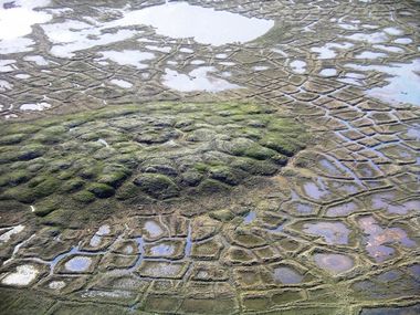
==Possible pingos== | ==Possible pingos== | ||
| + | |||
For many years, Pingos were believed to be present on Mars. Since they contain pure water ice, they would be a great source of water for future colonists on Mars. “Pingo is an Inuit word.<ref>http://www.uahirise.org/ESP_046359_1250</ref> One picture from HiRISE under the HiWish program was thought to be a pingo. The picture from the Phaethontis quadrangle shows radial and concentric cracks. These are common when forces penetrate a brittle layer, such as a rock thrown through a glass window. These particular fractures were probably created by something emerging from below the brittle Martian surface. Ice may have accumulated under the surface in a lens shape; thus making these cracked mounds. Ice being less dense than rock, pushed upwards on the surface and generated these spider web-like patterns. A similar process creates similar sized mounds in arctic tundra on Earth. Pingos would contain pure water ice; thus they could be sources of water for future colonists of Mars. | For many years, Pingos were believed to be present on Mars. Since they contain pure water ice, they would be a great source of water for future colonists on Mars. “Pingo is an Inuit word.<ref>http://www.uahirise.org/ESP_046359_1250</ref> One picture from HiRISE under the HiWish program was thought to be a pingo. The picture from the Phaethontis quadrangle shows radial and concentric cracks. These are common when forces penetrate a brittle layer, such as a rock thrown through a glass window. These particular fractures were probably created by something emerging from below the brittle Martian surface. Ice may have accumulated under the surface in a lens shape; thus making these cracked mounds. Ice being less dense than rock, pushed upwards on the surface and generated these spider web-like patterns. A similar process creates similar sized mounds in arctic tundra on Earth. Pingos would contain pure water ice; thus they could be sources of water for future colonists of Mars. | ||
| Line 104: | Line 104: | ||
<gallery class="center" widths="380px" heights="360px"> | <gallery class="center" widths="380px" heights="360px"> | ||
| − | + | ||
File:46622 1365contextccf.jpg|Concentric crater fill, as seen by HiRISE under HiWish program | File:46622 1365contextccf.jpg|Concentric crater fill, as seen by HiRISE under HiWish program | ||
| Line 140: | Line 140: | ||
<gallery class="center" widths="380px" heights="360px"> | <gallery class="center" widths="380px" heights="360px"> | ||
| − | + | ||
| − | |||
ESP 046042 1420pits.jpg|Pits in troughs, as seen by HiRISE under HiWish program | ESP 046042 1420pits.jpg|Pits in troughs, as seen by HiRISE under HiWish program | ||
</gallery> | </gallery> | ||
| Line 150: | Line 149: | ||
Image:24416craterfloor.jpg|Surface of crater floor, as seen by HiRISE under HiWish program. | Image:24416craterfloor.jpg|Surface of crater floor, as seen by HiRISE under HiWish program. | ||
| − | Image:25246brainseroding.jpg| | + | Image:25246brainseroding.jpg|Brain terrain on crater floor |
| − | + | ||
Image:25484hollowsclose.jpg|Close-up of surface with large hollows, as seen by HiRISE under HiWish program. | Image:25484hollowsclose.jpg|Close-up of surface with large hollows, as seen by HiRISE under HiWish program. | ||
</gallery> | </gallery> | ||
| Line 161: | Line 160: | ||
The density of impact craters is used to determine the surface ages of Mars and other solar system bodies.<ref>http://www.lpi.usra.edu/publications/slidesets/stones/</ref> The older the surface, the more craters present. Crater shapes can reveal the presence of ground ice. | The density of impact craters is used to determine the surface ages of Mars and other solar system bodies.<ref>http://www.lpi.usra.edu/publications/slidesets/stones/</ref> The older the surface, the more craters present. Crater shapes can reveal the presence of ground ice. | ||
| − | + | ||
| + | [[FIle:Wikinansenwest.jpg|thumb|West side of [[Nansen Crater]], as seen by CTX camera (on Mars Reconnaissance Orbiter).]] | ||
The area around craters may be rich in minerals. On Mars, heat from the impact melts ice in the ground. Water from the melting ice dissolves minerals, and then deposits them in cracks or faults that were produced with the impact. This process, called hydrothermal alteration, is a major way in which ore deposits are produced. The area around Martian craters may be rich in useful ores for the future colonization of Mars.<ref>http://www.indiana.edu/~sierra/papers/2003/Patterson.html.</ref> Studies on the earth have documented that cracks are produced during an impact episode and that secondary minerals veins are deposited in the cracks.<ref>Osinski, G, J. Spray, and P. Lee. 2001. Impact-induced hydrothermal activity within the Haughton impact structure, arctic Canada: Generation of a transient, warm, wet oasis. Meteoritics & Planetary Science: 36. 731-745</ref><ref>http://www.ingentaconnect.com/content/arizona/maps/2005/00000040/00000012/art00007</ref><ref>Pirajno, F. 2000. Ore Deposits and Mantle Plumes. Kluwer Academic Publishers. Dordrecht, The Netherlands</ref> Images from satellites orbiting Mars have detected cracks near impact craters.<ref>Head, J. and J. Mustard. 2006. Breccia Dikes and Crater-Related Faults in Impact Craters on Mars: Erosion and Exposure on the Floor of a 75-km Diameter Crater at the Dichotomy Boundary. Special Issue on Role of Volatiles and Atmospheres on Martian Impact Craters Meteoritics & Planetary Science</ref> Great amounts of heat are produced during impacts. The area around a large impact may take hundreds of thousands of years to cool.<ref>name="news.discovery.com"</ref> <ref>Segura, T, O. Toon, A. Colaprete, K. Zahnle. 2001. Effects of Large Impacts on Mars: Implications for River Formation. American Astronomical Society, DPS meeting#33, #19.08</ref><ref>Segura, T, O. Toon, A. Colaprete, K. Zahnle. 2002. Environmental Effects of Large Impacts on Mars. Science: 298, 1977-1980.</ref> The heat from the impacts could lead to ore formation and to lakes in the craters. | The area around craters may be rich in minerals. On Mars, heat from the impact melts ice in the ground. Water from the melting ice dissolves minerals, and then deposits them in cracks or faults that were produced with the impact. This process, called hydrothermal alteration, is a major way in which ore deposits are produced. The area around Martian craters may be rich in useful ores for the future colonization of Mars.<ref>http://www.indiana.edu/~sierra/papers/2003/Patterson.html.</ref> Studies on the earth have documented that cracks are produced during an impact episode and that secondary minerals veins are deposited in the cracks.<ref>Osinski, G, J. Spray, and P. Lee. 2001. Impact-induced hydrothermal activity within the Haughton impact structure, arctic Canada: Generation of a transient, warm, wet oasis. Meteoritics & Planetary Science: 36. 731-745</ref><ref>http://www.ingentaconnect.com/content/arizona/maps/2005/00000040/00000012/art00007</ref><ref>Pirajno, F. 2000. Ore Deposits and Mantle Plumes. Kluwer Academic Publishers. Dordrecht, The Netherlands</ref> Images from satellites orbiting Mars have detected cracks near impact craters.<ref>Head, J. and J. Mustard. 2006. Breccia Dikes and Crater-Related Faults in Impact Craters on Mars: Erosion and Exposure on the Floor of a 75-km Diameter Crater at the Dichotomy Boundary. Special Issue on Role of Volatiles and Atmospheres on Martian Impact Craters Meteoritics & Planetary Science</ref> Great amounts of heat are produced during impacts. The area around a large impact may take hundreds of thousands of years to cool.<ref>name="news.discovery.com"</ref> <ref>Segura, T, O. Toon, A. Colaprete, K. Zahnle. 2001. Effects of Large Impacts on Mars: Implications for River Formation. American Astronomical Society, DPS meeting#33, #19.08</ref><ref>Segura, T, O. Toon, A. Colaprete, K. Zahnle. 2002. Environmental Effects of Large Impacts on Mars. Science: 298, 1977-1980.</ref> The heat from the impacts could lead to ore formation and to lakes in the craters. | ||
| Line 170: | Line 170: | ||
Image:ESP_028214_1435cratermesa.jpg|Mesa in a crater, as seen by HiRISE under HiWish program. | Image:ESP_028214_1435cratermesa.jpg|Mesa in a crater, as seen by HiRISE under HiWish program. | ||
| + | |||
Image:28595mantlelayers.jpg|Layers in mantle, as seen by HiRISE under HiWish program. | Image:28595mantlelayers.jpg|Layers in mantle, as seen by HiRISE under HiWish program. | ||
</gallery> | </gallery> | ||
| Line 183: | Line 184: | ||
ESP 034887 1490ridgesphaethontisclose.jpg|Close-up of linear ridge networks from the previous image, as seen by HiRISE under HiWish program | ESP 034887 1490ridgesphaethontisclose.jpg|Close-up of linear ridge networks from the previous image, as seen by HiRISE under HiWish program | ||
ESP 036443 1495ridgesphaethontistop.jpg|Linear ridge networks, as seen by HiRISE under HiWish program | ESP 036443 1495ridgesphaethontistop.jpg|Linear ridge networks, as seen by HiRISE under HiWish program | ||
| − | + | ||
</gallery> | </gallery> | ||
| Line 207: | Line 208: | ||
<gallery class="center" widths="380px" heights="360px"> | <gallery class="center" widths="380px" heights="360px"> | ||
| − | + | ||
| − | + | ||
| − | |||
Esp 037167 1445mantle.jpg|Surface showing appearance with and without mantle covering, as seen by HiRISE, under the [[HiWish program]] Location is [[Terra Sirenum]] in Phaethontis quadrangle. | Esp 037167 1445mantle.jpg|Surface showing appearance with and without mantle covering, as seen by HiRISE, under the [[HiWish program]] Location is [[Terra Sirenum]] in Phaethontis quadrangle. | ||
File:ESP 056826 1445mantle.jpg|Surface appearance with and without mantle, as seen by HiRISE, under the HiWish program | File:ESP 056826 1445mantle.jpg|Surface appearance with and without mantle, as seen by HiRISE, under the HiWish program | ||
| − | + | ||
</gallery> | </gallery> | ||
| Line 241: | Line 241: | ||
File:ESP 057581 1340devils.jpg|Wide view of dust devil tracks, as seen by HiRISE under HiWish program | File:ESP 057581 1340devils.jpg|Wide view of dust devil tracks, as seen by HiRISE under HiWish program | ||
| − | File:ESP 057581 1340devils3.jpg|Close | + | File:ESP 057581 1340devils3.jpg|Close, color view of ust devil tracks, as seen by HiRISE under HiWish program |
| − | |||
| − | |||
File:57581 1340devils.jpg|Close view of dust devil tracks, as seen by HiRISE under HiWish program | File:57581 1340devils.jpg|Close view of dust devil tracks, as seen by HiRISE under HiWish program | ||
| − | |||
</gallery> | </gallery> | ||
| Line 254: | Line 251: | ||
<gallery class="center" widths="380px" heights="360px"> | <gallery class="center" widths="380px" heights="360px"> | ||
| − | + | ||
Image:Phaethontis.JPG|Map of Phaethontis quadrangle. Click on to enlarge and see some crater names. | Image:Phaethontis.JPG|Map of Phaethontis quadrangle. Click on to enlarge and see some crater names. | ||
Image:Phaethontis surface.JPG|Close up image of Phaethontis surface taken with [[Mars Global Surveyor]]. Holes are thought to be caused by buried ice turning into a gas. | Image:Phaethontis surface.JPG|Close up image of Phaethontis surface taken with [[Mars Global Surveyor]]. Holes are thought to be caused by buried ice turning into a gas. | ||
| − | |||
</gallery> | </gallery> | ||
| Line 264: | Line 260: | ||
<gallery class="center" widths="380px" heights="360px"> | <gallery class="center" widths="380px" heights="360px"> | ||
| − | + | ||
51184 1345hollowspits.jpg|Close view of hollows, as seen by HiRISE under HiWish program | 51184 1345hollowspits.jpg|Close view of hollows, as seen by HiRISE under HiWish program | ||
51184 1345hollows.jpg|Close view of hollows, as seen by HiRISE under HiWish program | 51184 1345hollows.jpg|Close view of hollows, as seen by HiRISE under HiWish program | ||
Revision as of 10:19, 12 March 2020
| MC-24 | Phaethontis | 30–65° S | 120–180° W | Quadrangles | Atlas |


The Phaethontis quadrangle hosts a variety of interesting phenonomon. It has an enormous number of craters since it is so old. Gullies occur in many of the craters. For many years, we excited about the gullies because we thought they were made by recent running water. Traces of magnetic field lines exist here—those hint of some primitive, ancient plate tectonics. There was a large lake in this quadrangle. The Phaethontis quadrangle is one of a series of list of quadrangles used by the United States Geological Survey (USGS). The Phaethontis quadrangle is also referred to as MC-24 (Mars Chart-24).[1] The name comes from Phaethon, the son of Helios.[2] The Phaethontis quadrangle lies between 30° and 65 ° south latitude and 120° and 180 ° west longitude (240-180 E). This latitude range is where numerous gullies have been discovered. Mars Reconnaissance Orbiter discovered iron/magnesium smectites in an old feature in this area, called Terra Sirenum in this quadrangle. The discovery of these clay minerals here is good evidence of water in the past.[3] Part of this quadrangle contains what is called the Electris deposits, a deposit that is 100–200 m thick. It is light-toned and appears to be weak because of few boulders.[4] Among a group of large craters is Mariner Crater, first observed by the Mariner IV spacecraft in the summer of 1965. It was named after that spacecraft.[5] A low area in Terra Sirenum is believed to have once held a lake that eventually drained through a valley called Ma'adim Vallis.[6] [7] [8] Russia's Mars 3 probe landed in the Phaethontis quadrangle at 44.9° S and 160.1° W in December 1971. It landed at a speed of 75 km per hour, but survived to radio back 20 seconds of signal, then it went dead. Its message just appeared as a blank screen.[9]
Contents
- 1 Martian gullies
- 2 Associated features of gullies
- 3 Tongue-shaped glaciers
- 4 Possible pingos
- 5 Concentric crater fill
- 6 Magnetic stripes and plate tectonics
- 7 Chloride deposits
- 8 Fossae
- 9 Strange surfaces
- 10 Craters
- 11 Linear ridge networks
- 12 Dunes
- 13 Mantle
- 14 Channels
- 15 Dust devil tracks
- 16 Other scenes in Phaethontis quadrangle
- 17 See also
- 18 References
- 19 External links
Martian gullies
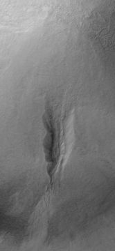
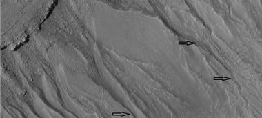
The Phaethontis quadrangle is the location of many gullies that were thought to be caused by recent flowing water. However, with further extensive observations with HiRISE it was found that many are forming/changing today, even though liquid water cannot exist under current Martian conditions. Scientists came up with other ideas to explain them. The conscious seems to be that although water may have helped form them in the past, today they are being produced by chunks of dry ice moving down steep slopes. [10] [11] [12] Some are found in the GorgonumChaos[13] [14] and in many craters near the large craters Copernicus and Newton (Martian Crater.[15][16] Gullies occur on steep slopes, especially on the walls of craters. Gullies are believed to be relatively young because they have few, if any craters. Moreover, they lie on top of sand dunes which themselves are considered to be quite young. Usually, each gully has an alcove, channel, and apron.[17]

Electris Deposit, as seen by HiRISE Electris deposit is light-toned and smooth in the image in contrast to rough materials below. Location is Phaethontis quadrangle.

Layers in light-toned Electris Deposit, as seen by HiRISE on the Mars Reconnaissance Orbiter. Gullies are visible on the left.

Gorgonum Chaos as seen by Mars Reconnaissance Orbiter HiRISE. Image about 4 km wide.

Group of gullies on north wall of crater that lies west of the crater Newton (41.3047 degrees south latitude, 192.89 east longitide). Image taken with Mars Global Surveyor under the MOC Public Targeting Program.

CTX image of the next image showing a wide view of the area. Since the hill is isolated it would be difficult for an aquifer to develop. Rectangle shows the approximate location of the next image.
Gully on mound as seen by Mars Global Surveyor, under the MOC Public Targeting Program. Images of gullies on isolated peaks, like this one, are difficult to explain with the theory of water coming from aquifers because aquifers need large collecting areas.

Another view of the previous gully on a mound. This one is with HiRISE, under the HiWish program. This view shows most of the apron and two old glaciers associated with it. All that is left of the glaciers are terminal moraines.

MOLA context image for the series of three images to follow of gullies in a trough and nearby crater.

Close-up of gullies in crater, as seen by HiRISE under the HiWish program.

Gullies near Newton Crater, as seen by HiRISE, under the HiWish program. Place where there was an old glacier is labeled.

Gullies with remains of a former glacier in crater in Terra Sirenum, as seen by HiRISE under HiWish program.

Gullies near Newton Crater, as seen by HiRISE under the HiWish Program.

Gullies in a crater in Terra Sirenum, as seen by HiRISE under the HiWish Program.

Close-up of gully showing multiple channels and patterned ground, as seen by HiRISE under the HiWish program
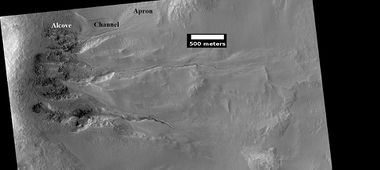
Image of gullies with main parts labeled. The main parts of a Martian gully are alcove, channel, and apron. Since there are no craters on this gully, it is thought to be rather young. Picture was taken by HiRISE under HiWish program. Location is Phaethontis quadrangle.

Gullies in crater, as seen by HiRISE under HiWish program. Location is Phaethontis quadrangle.
Close up of gullies in crater showing channels within larger valleys and curves in channels. These characteristics suggest they were made by flowing water. Note: this is an enlargement of the previous image by HiRISE under HiWish program. Location is Phaethontis quadrangle.

Close up of gully network showing branched channels and curves; these characteristics suggest creation by a fluid. Note: this is an enlargement of a previous wide view of gullies in a crater, as seen by HiRISE under HiWish program. Location is Phaethontis quadrangle.


Associated features of gullies
Sometimes other features appear near gullies. At the base of some gullies there may be depressions or curved ridges. These have been called "spatulate depressions." These depressions form after glacial ice disappears. Steep walls often develop glaciers during certain climates. Ice or most of the ice has left some Martian glaciers because when the climate changes, the ice in the glaciers sublimates in the thin Martian atmosphere. Sublimation is when a substance goes directly from a solid state to a gas state. Dry ice on Earth does this. So if the ice at the base of a steep wall sublimates, a depression results. And then, more ice from higher up will tend to flow downward. This flow will stretch the surface rocky debris thereby forming transverse crevasses. Such formations have been termed "washboard terrain" because they resemble the old fashioned washboards.[18] The parts of gullies and some associated features of gullies are shown below in a HiRISE images.

Wide view of crater showing gullies and other features, as seen by HiRISE

Close view of crater labeled with "spatulate depression" and other features, as seen by HiRISE Note: this is an enlargement of the previous image.[19]

Close view of crater labeled with "washboard terrain" and other features, as seen by HiRISE Note: this is an enlargement of a previous image. The washboard terrain was formed before the gully apron since the gully apron cuts across the washboard terrain.[19]


Tongue-shaped glaciers

Tongue-shaped glacier, as seen by HiRISE under the HiWish program. Location is Phaethontis quadrangle.

Possible pingos
For many years, Pingos were believed to be present on Mars. Since they contain pure water ice, they would be a great source of water for future colonists on Mars. “Pingo is an Inuit word.[20] One picture from HiRISE under the HiWish program was thought to be a pingo. The picture from the Phaethontis quadrangle shows radial and concentric cracks. These are common when forces penetrate a brittle layer, such as a rock thrown through a glass window. These particular fractures were probably created by something emerging from below the brittle Martian surface. Ice may have accumulated under the surface in a lens shape; thus making these cracked mounds. Ice being less dense than rock, pushed upwards on the surface and generated these spider web-like patterns. A similar process creates similar sized mounds in arctic tundra on Earth. Pingos would contain pure water ice; thus they could be sources of water for future colonists of Mars.

Possible pingo, as seen by HiRISE under HiWish program

Possible pingos with scale, as seen by HiRISE under HiWish program
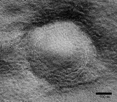
Close view of possible pingo with scale, as seen by HiRISE under HiWish program
Example of a pingo on Earth. On Earth the ice that caused the pingo would melt and fill the fractures with water; on Mars the ice would turn into a gas in the thin Martian atmosphere.


Concentric crater fill
Concentric crater fill, like lobate debris aprons and lineated valley fill, is believed to be ice-rich.[21] Based on accurate topography measures of height at different points in these craters and calculations of how deep the craters should be based on their diameters, it is thought many craters are 80% filled with mostly ice.[22][23][24] [25] That is, they hold hundreds of meters of material that probably consists of ice with a few tens of meters of surface debris.[26] [27] The ice accumulated in the crater from snowfall in previous climates.[28] [29] [30] Recent modeling suggests that concentric crater fill develops over many cycles in which snow is deposited, then moves into the crater. Once inside the crater, shade and dust preserve the snow. The snow changes to ice. The many concentric lines are created by the many cycles of snow accumulation. Generally snow accumulates whenever the axial tilt reaches 35 degrees.[31] Concentric crater fill may be mined in the future for water for settlers.
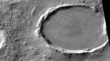
Crater showing concentric crater fill, as seen by CTX (on Mars Reconnaissance Orbiter). Location is Phaethontis quadrangle.
Close-up view of concentric crater fill, as seen by HiRISE under HiWish program Note: this is an enlargement of previous image of a concentric crater. Location is Phaethontis quadrangle.


Concentric crater fill, as seen by HiRISE under HiWish program
Close, color view of concentric crater fill, as seen by HiRISE under HiWish program


Magnetic stripes and plate tectonics
The Mars Global Surveyor (MGS) discovered magnetic stripes in the crust of Mars, especially in the Phaethontis and Eridania quadrangles (Terra Cimmeria and Terra Sirenum).[32] [33] The magnetometer, which detects magnetic fields, on MGS discovered 100 km wide stripes of magnetized crust running roughly parallel for up to 200 km. These stripes alternate in polarity with the north magnetic pole of one pointing up from the surface and the north magnetic pole of the next pointing down.[34] When similar stripes were discovered on Earth in the 1960s, they were taken as evidence of plate tectonics. Researchers believe these magnetic stripes on Mars are evidence for a short, early period of plate tectonic activity. When the rocks became solid they retained the magnetism that existed at the time. A magnetic field of a planet is believed to be caused by fluid motions under the surface.[35] [36] However, there are some differences, between the magnetic stripes on Earth and those on Mars. The Martian stripes are wider, much more strongly magnetized, and do not appear to spread out from a middle crustal spreading zone. Because the area containing the magnetic stripes is about 4 billion years old, it is believed that the global magnetic field probably lasted for only the first few hundred million years of Mars' life, when the temperature of the molten iron in the planet's core might have been high enough to mix it into a magnetic dynamo. There are no magnetic fields near large impact basins like Hellas. The shock of the impact may have erased the remnant magnetization in the rock. So, magnetism produced by early fluid motion in the core would not have existed after the impacts.[37]
When molten rock containing magnetic material, such as hematite (Fe2O3), cools and solidifies in the presence of a magnetic field, it becomes magnetized and takes on the polarity of the background field. This magnetism is lost only if the rock is subsequently heated above a particular temperature (the Curie point which is 770 °C for iron). The magnetism left in rocks is a record of the magnetic field when the rock solidified.[38] Since heat will remove the magnetism from a substance, the heat of big impacts would have wiped out any trace of a magnetic field.

Global map of magnetic anomalies Large craters and volcanoes are in dark green. Solid line represents the dichotomy boundary.

Chloride deposits
Using data from Mars Global Surveyor, Mars Odyssey and the Mars Reconnaissance Orbiter, scientists have found widespread deposits of chloride minerals. A picture below shows some deposits within the Phaethontis quadrangle. Evidence suggests that the deposits were formed from the evaporation of mineral enriched waters. Lakes may have been scattered over large areas of the Martian surface. Usually chlorides are the last minerals to come out of solution. Carbonates, sulfates, and silica should precipitate out ahead of them. Sulfates and silica have been found by the Mars Rovers Spirit and Opportunity on the surface. Places with chloride minerals may have once held various life forms. Furthermore, such areas should preserve traces of ancient life.[39]
Based on chloride deposits and hydrated phyllosilicates, Alfonso Davila and others believe there is an ancient lakebed in Terra Sirenum that had an area of 30,000 square kilometers and was 200 meters deep. Other evidence that supports this lake are normal and inverted channels like ones found in the Atacama desert.[40]

Evidence of water from chloride deposits in Phaethontis. Picture from HiRISE.

Fossae
The Elysium quadrangle is home to large troughs (long narrow depressions) called fossae in the geographical language used for Mars. Troughs are created when the crust is stretched until it breaks. The stretching can be due to the large weight of a nearby volcano. Fossae/pit craters are common near volcanoes in the Tharsis and Elysium system of volcanoes.[41]

Pits in troughs, as seen by HiRISE under HiWish program

Strange surfaces

Surface of crater floor, as seen by HiRISE under HiWish program.

Brain terrain on crater floor

Close-up of surface with large hollows, as seen by HiRISE under HiWish program.


Craters
.png)
The density of impact craters is used to determine the surface ages of Mars and other solar system bodies.[42] The older the surface, the more craters present. Crater shapes can reveal the presence of ground ice.

The area around craters may be rich in minerals. On Mars, heat from the impact melts ice in the ground. Water from the melting ice dissolves minerals, and then deposits them in cracks or faults that were produced with the impact. This process, called hydrothermal alteration, is a major way in which ore deposits are produced. The area around Martian craters may be rich in useful ores for the future colonization of Mars.[43] Studies on the earth have documented that cracks are produced during an impact episode and that secondary minerals veins are deposited in the cracks.[44][45][46] Images from satellites orbiting Mars have detected cracks near impact craters.[47] Great amounts of heat are produced during impacts. The area around a large impact may take hundreds of thousands of years to cool.[48] [49][50] The heat from the impacts could lead to ore formation and to lakes in the craters. Many craters once contained lakes.[51] [52] [53] Because some crater floors show deltas, we know that water had to be present for some time. Dozens of deltas have been spotted on Mars.[54] Deltas form when sediment is washed in from a stream entering a quiet body of water. It takes a bit of time to form a delta, so the presence of a delta is exciting; it means water was there for a time, maybe for many years. Primitive organisms may have developed in such lakes; hence, some craters may be prime targets for the search for evidence of life on the Red Planet.[55]

Mesa in a crater, as seen by HiRISE under HiWish program.

Layers in mantle, as seen by HiRISE under HiWish program.


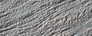
Linear ridge networks
Linear ridge networks are found in various places on Mars in and around craters.[56] Ridges often appear as mostly straight segments that intersect in a lattice-like manner. They are hundreds of meters long, tens of meters high, and several meters wide. One popular idea for their creation mechanism is that impacts created fractures in the surface, these fractures later acted as channels for fluids. Fluids cemented the structures. With the passage of time, surrounding material was eroded away, thereby leaving hard ridges behind. However, scientists are not all in agreement as to the exact cause of these odd features. Since the ridges occur in locations with clay, these formations could serve as a marker for clay which requires water for its formation.[57] [58] [59] Water here could have supported past life in these locations. Clay may also preserve fossils or other traces of past life.

Linear ridge networks, as seen by HiRISE under HiWish program

Close-up of linear ridge networks from the previous image, as seen by HiRISE under HiWish program

Linear ridge networks, as seen by HiRISE under HiWish program


Dunes
Sand dunes have been found in many places on Mars. The presence of dunes shows that the planet has an atmosphere with wind, for dunes require wind to pile up the sand. Most dunes on Mars are black because of the weathering of the volcanic rock basalt.[60][61] Black sand can be found on Earth on Hawaii and on some tropical South Pacific islands.[62] Sand is common on Mars due to the old age of the surface that has allowed rocks to erode into sand. Dunes on Mars have been observed to move many meters.[63] [64] For a dune to move, sand moves up the windward side and then falls down the leeward side of the dune, thus caused the dune to go toward the leeward side (or slip face).[65] When images are enlarged, some dunes on Mars display ripples on their surfaces.[66] These are caused by sand grains rolling and bouncing up the windward surface of a dune. The bouncing grains tend to land on the windward side of each ripple. The grains do not bounce very high so it does not take much to stop them. When they land they settle in such a way that prevents further movement.

Dunes in Newton (Martian crater), as seen by HiRISE under HiWish program

Close view of dunes in Newton Crater, as seen by HiRISE under HiWish program

Close view of dunes in Newton Crater, as seen by HiRISE under HiWish program
Close view of dunes in Newton Crater showing ripples on surface, as seen by HiRISE under HiWish program


Mantle
Much of the Martian surface is covered with a thick ice-rich, mantle layer that has fallen from the sky a number of times in the past.[67] [68][69] In some places a number of layers are visible in the mantle.[70]
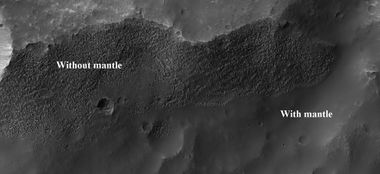
Surface showing appearance with and without mantle covering, as seen by HiRISE, under the HiWish program Location is Terra Sirenum in Phaethontis quadrangle.

Surface appearance with and without mantle, as seen by HiRISE, under the HiWish program


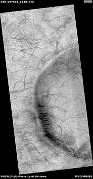
Channels
There is enormous evidence that water once flowed in river valleys on Mars.[71] [72] Images of curved channels have been seen in images from Mars spacecraft dating back to the early seventies with the Mariner 9 orbiter.[73] [74] [75][76] Indeed, a study published in June 2017, calculated that the volume of water needed to carve all the channels on Mars was even larger than the proposed ocean that the planet may have had. Water was probably recycled many times from the ocean to rainfall around Mars.[77] [78]

Channel, as seen by HiRISE under HiWish program Streamlined shapes are indicated with arrows.
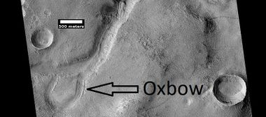
Oxbow lake, as seen by HiRISE under HiWish program

Channel connecting two craters, as seen by HiRISE under HiWish program

Channels, as seen by HiRISE under HiWish program

Channels, as seen by HiRISE under HiWish program


Dust devil tracks
Because a thin coating of fine bright dust covers much of the surface of Mars, passing dust devils remove the bright dust and expose the underlying dark surface.[79] [80] It does not take too much fine dust to cover those tracks--experiments in Earth laboratories demonstrate that only a few 10's of microns of dust will be enough. The width of a single human hair ranges from approximately 20 to 200 microns (μm); consequently, the dust that can cover dust devil tracks may only be the thickness of a human hair.[81] Dust devils have been seen from the ground and from orbiting spacecraft. They have even blown the dust off of the solar panels of the two Mars Exploration Rovers on Mars, thereby greatly extending their lives.[82]
Wide view of dust devil tracks, as seen by HiRISE under HiWish program

Close, color view of ust devil tracks, as seen by HiRISE under HiWish program

Close view of dust devil tracks, as seen by HiRISE under HiWish program


Other scenes in Phaethontis quadrangle
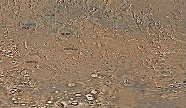
Map of Phaethontis quadrangle. Click on to enlarge and see some crater names.

Close up image of Phaethontis surface taken with Mars Global Surveyor. Holes are thought to be caused by buried ice turning into a gas.


Close view of hollows, as seen by HiRISE under HiWish program

Close view of hollows, as seen by HiRISE under HiWish program


See also
- Dark slope streaks
- Geography of Mars
- High Resolution Imaging Science Experiment (HiRISE)
- HiWish program
- How are features on Mars Named?
- Glaciers on Mars
- Layers on Mars
- Mars Global Surveyor
- Martian features that are signs of water ice
- Martian gullies
- Oceans on Mars
- Periodic climate changes on Mars
- Rivers on Mars
- Sublimation landscapes on Mars
References
- ↑ Davies |first1= M.E. |last2= Batson |first2= R.M. |last3= Wu |first3= S.S.C. |chapter= Geodesy and Cartography |editor1-last= Kieffer |editor1-first= H.H. |editor2-last= Jakosky |editor2-first= B.M. |editor3-last= Snyder |editor3-first= C.W. |display-editors= 3 |editor4-last= Matthews |editor4-first= M.S. |title= Mars |publisher= University of Arizona Press |location= Tucson |date= 1992 |isbn= 978-0-8165-1257-7 |
- ↑ Blunck, J. 1982. Mars and its Satellites, Exposition Press. Smithtown, N.Y.
- ↑ Murchie |first1= S. |date= 2009 | display-authors=4 | last2=Mustard | first2=John F. | last3=Ehlmann | first3=Bethany L. | last4=Milliken | first4=Ralph E. | last5=Bishop | first5=Janice L. | last6=McKeown | first6=Nancy K. | last7=Noe Dobrea | first7=Eldar Z. | last8=Seelos | first8=Frank P. | last9=Buczkowski | first9=Debra L. |last10= Wiseman |first10= Sandra M. |last11= Arvidson |first11= Raymond E. |last12= Wray |first12= James J. |last13= Swayze |first13= Gregg |last14= Clark |first14= Roger N. |last15= Des Marais |first15= David J. |last16= McEwen |first16= Alfred S. |last17= Bibring |first17= Jean-Pierre |title= A synthesis of Martian aqueous mineralogy after 1 Mars year of observations from the Mars Reconnaissance Orbiter |journal= Journal of Geophysical Research |volume= 114 |issue= E2 || url=http://www.planetary.brown.edu/pdfs/3964.pdf | doi = 10.1029/2009JE003342 | page=E00D06
- ↑ Grant |first1= J. | display-authors=4 | last2=Wilson|date= 2010 | first2=Sharon A. | last3=Noe Dobrea | first3=Eldar | last4=Fergason | first4=Robin L. | last5=Griffes | first5=Jennifer L. | last6=Moore | first6=Jeffery M. | last7=Howard | first7=Alan D. |title= HiRISE views enigmatic deposits in the Sirenum Fossae region of Mars |journal = Icarus |volume= 205 | issue=1 |pages= 53–63 |
- ↑ Kieffer, Hugh H. |title=Mars |publisher=University of Arizona Press |location=Tucson |date=1992 |pages= |isbn=978-0-8165-1257-7 |oclc= |doi= |accessdate= |url-access=registration |url=https://archive.org/details/mars0000unse
- ↑ https://www.uahirise.org/ESP_050948_1430
- ↑ Rossman P. | last2=Howard | first2=Alan D. | last3=Maxwell | first3=Ted A. | title=Geomorphology of Ma'adim Vallis, Mars, and associated paleolake basins | journal=Journal of Geophysical Research | volume=109 | issue=E12 | pages=12009 | date=2004 | doi=10.1029/2004JE002287 |
- ↑ Michael Carr |title=The surface of Mars |publisher=Cambridge University Press |location=Cambridge, UK |date=2006 |pages= |isbn=978-0-521-87201-0 |oclc= |
- ↑ Hartmann |first1= W. |date= 2003 |title= A Traveler's Guide to Mars |publisher= Workman Publishing |location= New York |isbn= 978-0-7611-2606-5 |page= |url-access= registration |url= https://archive.org/details/travelersguideto00will
- ↑ Harrington |first=J.D. |last2=Webster |first2=Guy |title=RELEASE 14-191 – NASA Spacecraft Observes Further Evidence of Dry Ice Gullies on Mars |url=http://www.nasa.gov/press/2014/july/nasa-spacecraft-observes-further-evidence-of-dry-ice-gullies-on-mars |date=July 10, 2014 |work=NASA
- ↑ CNRS. "Gullies on Mars sculpted by dry ice rather than liquid water." ScienceDaily. ScienceDaily, 22 December 2015. www.sciencedaily.com/releases/2015/12/151222082255.htm
- ↑ http://www.skyandtelescope.com/astronomy-news/martian-gullies-triggered-by-exploding-dry-ice-122320158
- ↑ http://hirise.lpl.arizona.edu/PSP_004071_1425
- ↑ http://hirise.lpl.arizona.edu/PSP_001948_1425
- ↑ http://hirise.lpl.arizona.edu/PSP_004163_1375
- ↑ U.S. department of the Interior U.S. Geological Survey, Topographic Map of the Eastern Region of Mars M 15M 0/270 2AT, 1991
- ↑ Edgett |first1= K. |last2= Malin |first2= M. C. |last3= Williams |first3= R. M. E. |last4= Davis |first4= S. D. |date= 2003 |title= Polar-and middle-latitude martian gullies: A view from MGS MOC after 2 Mars years in the mapping orbit |journal= Lunar Planet. Sci. |volume=34 |at=p. 1038, Abstract 1038 | url=http://www.lpi.usra.edu/meetings/lpsc2003/pdf/1038.pdf |
- ↑ Jawin, E, J. Head, D. Marchant. 2018. Transient post-glacial processes on Mars: Geomorphologic evidence for a paraglacial period. Icarus: 309, 187-206
- ↑ 19.0 19.1 Cite error: Invalid
<ref>tag; no text was provided for refs namedJ. Head, D. Marchant 2018 - ↑ http://www.uahirise.org/ESP_046359_1250
- ↑ Levy, J. et al. 2009. Concentric crater fill in Utopia Planitia: History and interaction between glacial "brain terrain" and periglacial processes. Icarus: 202. 462-476.
- ↑ Head | first2 = J. | last3 = Marchant | first3 = D. | year = 2010 | title = Concentric Crater fill in the northern mid-latitudes of Mars: Formation process and relationships to similar landforms of glacial origin | doi = 10.1016/j.icarus.2010.03.036 | journal = Icarus | volume = 209 | issue = 2| pages = 390–404 | bibcode = 2010Icar..209..390L }}
- ↑ {{cite journal | last1 = Levy | first1 = J. | last2 = Head | first2 = J. | last3 = Dickson | first3 = J. | last4 = Fassett | first4 = C. | last5 = Morgan | first5 = G. | last6 = Schon | first6 = S. | year = 2010 | title = Identification of gully debris flow deposits in Protonilus Mensae, Mars: Characterization of a water-bearing, energetic gully-forming process | url = | journal = Earth Planet. Sci. Lett. | volume = 294 | issue = 3–4| pages = 368–377 | doi=10.1016/j.epsl.2009.08.002|
- ↑ http://hirise.lpl.arizona.edu/ESP_032569_2225
- ↑ Garvin, J., S. Sakimoto, J. Frawley. 2003. Craters on Mars: Geometric properties from gridded MOLA topography. In: Sixth International Conference on Mars. July 20–25, 2003, Pasadena, California. Abstract 3277.
- ↑ Garvin, J. et al. 2002. Global geometric properties of martian impact craters. Lunar Planet. Sci: 33. Abstract # 1255.
- ↑ http://photojournal.jpl.nasa.gov/catalog/PIA09662
- ↑ Kreslavsky, M. and J. Head. 2006. Modification of impact craters in the northern plains of Mars: Implications for the Amazonian climate history. Meteorit. Planet. Sci.: 41. 1633-1646
- ↑ Madeleine, J. et al. 2007. Exploring the northern mid-latitude glaciation with a general circulation model. In: Seventh International Conference on Mars. Abstract 3096.
- ↑ http://hirise.lpl.arizona.edu/PSP_002917_2175
- ↑ Fastook, J., J.Head. 2014. Concentric crater fill: Rates of glacial accumulation, infilling and deglaciation in the Amazonian and Noachian of Mars. 45th Lunar and Planetary Science Conference (2014) 1227.pdf
- ↑ Nadine G. |last=Barlow |title=Mars: an introduction to its interior, surface and atmosphere |publisher=Cambridge University Press |location=Cambridge, UK |date=2008 |pages= |isbn=978-0-521-85226-5
- ↑ Philippe Lognonné |author2=François Forget |author3=François Costard |title=Planet Mars: Story of Another World (Springer Praxis Books / Popular Astronomy) |publisher=Praxis |location= |date=2007 |pages= |isbn=978-0-387-48925-4 |oclc= |
- ↑ Fredric W. Taylor |title=The Scientific Exploration of Mars |publisher=Cambridge University Press |location=Cambridge, UK |date=2010 |pages= |isbn=978-0-521-82956-4 |
- ↑ Connerney JE |display-authors=4 |author2=Acuna MH |author3=Wasilewski PJ |title=Magnetic lineations in the ancient crust of mars |journal=Science |volume=284 |issue=5415 |pages=794–8 |date=April 1999 |pmid=10221909 |doi=10.1126/science.284.5415.794 |url=http://www.astro.wisc.edu/~ewilcots/courses/astro340s04/readings/marstectonics.pdf |bibcode=1999Sci...284..794C |last4=Reme |last5=Mazelle |last6=Vignes |last7=Lin |last8=Mitchell |last9=Cloutier
- ↑ Connerney | first1= J. E. P. | display-authors= 4 | last2= Acuña | first2= MH | last3= Ness | first3= NF | last4= Kletetschka | first4= G | last5= Mitchell | first5= DL | last6= Lin | first6= RP | last7= Reme | first7= H | title= Tectonic implications of Mars crustal magnetism | journal= Proceedings of the National Academy of Sciences | volume= 102 | issue= 42 | pages= 14970–14975 | pmid=16217034 | date= 2005 | doi=10.1073/pnas.0507469102 |
- ↑ Connerney | first2=JE | last3=Ness | first3=NF | last4=Lin | first4=RP | last5=Mitchell | first5=D | last6=Carlson | first6=CW | last7=McFadden | first7=J | last8=Anderson | first8=KA | last9=Reme | first9=H | last10=Mazelle | first10=C | last11=Vignes | first11=D | last12=Wasilewski | first12=P | last13=Cloutier | first13=P | title=Global distribution of crustal magnetization discovered by the Mars Global Surveyor MAG/ER Experiment | journal=Science | volume=284 | issue=5415 | pages= 790–793 | date=1999 | pmid = 10221908 |
- ↑ http://sci.esa.int/science-e/www/object/index.cfm?fobjectid=31028&fbodylongid=645
- ↑ Osterloo | first1= M. M. | display-authors= 4 | last2= Hamilton | first2= V. E. | last3= Bandfield | first3= J. L. | last4= Glotch | first4= T. D. | last5= Baldridge | first5= A. M. | last6= Christensen | first6= P. R. | last7= Tornabene | first7= L. L. | last8= Anderson | first8= F. S. | title= Chloride-Bearing Materials in the Southern Highlands of Mars | journal= Science | volume= 319 | issue= 5870 | pages= 1651–1654 |
- ↑ Davila | first1 = A. |display-authors=etal | year = 2011 | title = A large sedimentary basin in the Terra Sirenum region of the southern highlands of Mars | url = | journal = Icarus | volume = 212 | issue = 2| pages = 579–589 | doi=10.1016/j.icarus.2010.12.023|
- ↑ Skinner, J., L. Skinner, and J. Kargel. 2007. Re-assessment of Hydrovolcanism-based Resurfacing within the Galaxias Fossae Region of Mars. Lunar and Planetary Science XXXVIII (2007)
- ↑ http://www.lpi.usra.edu/publications/slidesets/stones/
- ↑ http://www.indiana.edu/~sierra/papers/2003/Patterson.html.
- ↑ Osinski, G, J. Spray, and P. Lee. 2001. Impact-induced hydrothermal activity within the Haughton impact structure, arctic Canada: Generation of a transient, warm, wet oasis. Meteoritics & Planetary Science: 36. 731-745
- ↑ http://www.ingentaconnect.com/content/arizona/maps/2005/00000040/00000012/art00007
- ↑ Pirajno, F. 2000. Ore Deposits and Mantle Plumes. Kluwer Academic Publishers. Dordrecht, The Netherlands
- ↑ Head, J. and J. Mustard. 2006. Breccia Dikes and Crater-Related Faults in Impact Craters on Mars: Erosion and Exposure on the Floor of a 75-km Diameter Crater at the Dichotomy Boundary. Special Issue on Role of Volatiles and Atmospheres on Martian Impact Craters Meteoritics & Planetary Science
- ↑ name="news.discovery.com"
- ↑ Segura, T, O. Toon, A. Colaprete, K. Zahnle. 2001. Effects of Large Impacts on Mars: Implications for River Formation. American Astronomical Society, DPS meeting#33, #19.08
- ↑ Segura, T, O. Toon, A. Colaprete, K. Zahnle. 2002. Environmental Effects of Large Impacts on Mars. Science: 298, 1977-1980.
- ↑ Cabrol, N. and E. Grin. 2001. The Evolution of Lacustrine Environments on Mars: Is Mars Only Hydrologically Dormant? Icarus: 149, 291-328.
- ↑ Fassett, C. and J. Head. 2008. Open-basin lakes on Mars: Distribution and implications for Noachian surface and subsurface hydrology. Icarus: 198, 37-56.
- ↑ Fassett, C. and J. Head. 2008. Open-basin lakes on Mars: Implications of valley network lakes for the nature of Noachian hydrology.
- ↑ Wilson, J. A. Grant and A. Howard. 2013. INVENTORY OF EQUATORIAL ALLUVIAL FANS AND DELTAS ON MARS. 44th Lunar and Planetary Science Conference.
- ↑ Newsom H., Hagerty J., Thorsos I. 2001. Location and sampling of aqueous and hydrothermal deposits in martian impact craters. Astrobiology: 1, 71-88.
- ↑ Head, J., J. Mustard. 2006. Breccia dikes and crater-related faults in impact craters on Mars: Erosion and exposure on the floor of a crater 75 km in diameter at the dichotomy boundary, Meteorit. Planet Science: 41, 1675-1690.
- ↑ Mangold |display-authors=etal | year = 2007 | title = Mineralogy of the Nili Fossae region with OMEGA/Mars Express data: 2. Aqueous alteration of the crust | url = | journal = J. Geophys. Res. | volume = 112| issue = E8|pages=E08S04 | doi = 10.1029/2006JE002835 |
- ↑ Mustard et al., 2007. Mineralogy of the Nili Fossae region with OMEGA/Mars Express data: 1. Ancient impact melt in the Isidis Basin and implications for the transition from the Noachian to Hesperian, J. Geophys. Res., 112.
- ↑ Mustard |display-authors=etal | year = 2009 | title = Composition, Morphology, and Stratigraphy of Noachian Crust around the Isidis Basin | url =https://authors.library.caltech.edu/34913/1/2009JE003349.pdf | journal = J. Geophys. Res. | volume = 114| issue = 7|pages=E00D12 | doi = 10.1029/2009JE003349 |
- ↑ http://hirise.lpl.arizona.edu/ESP_016459_1830
- ↑ Template:Cite book
- ↑ https://www.desertusa.com/desert-activity/sand-dune-wind1.html
- ↑ https://www.youtube.com/watch?v=ur_TeOs3S64
- ↑ https://uanews.arizona.edu/story/the-flowing-sands-of-mars
- ↑ Namowitz, S., Stone, D. 1975. earth science the world we live in. American Book Company. New York.
- ↑ https://www.jpl.nasa.gov/news/news.php?feature=6551
- ↑ Hecht, M. 2002. Metastability of water on Mars. Icarus 156, 373–386
- ↑ Mustard, J., et al. 2001. Evidence for recent climate change on Mars from the identification of youthful near-surface ground ice. Nature 412 (6845), 411–414.
- ↑ Pollack, J., D. Colburn, F. Flaser, R. Kahn, C. Carson, and D. Pidek. 1979. Properties and effects of dust suspended in the martian atmosphere. J. Geophys. Res. 84, 2929-2945.
- ↑ http://www.uahirise.org/ESP_048897_2125
- ↑ Baker, V., et al. 2015. Fluvial geomorphology on Earth-like planetary surfaces: a review. Geomorphology. 245, 149–182.
- ↑ Carr, M. 1996. in Water on Mars. Oxford Univ. Press.
- ↑ Baker, V. 1982. The Channels of Mars. Univ. of Tex. Press, Austin, TX
- ↑ Baker, V., R. Strom, R., V. Gulick, J. Kargel, G. Komatsu, V. Kale. 1991. Ancient oceans, ice sheets and the hydrological cycle on Mars. Nature 352, 589–594.
- ↑ Carr, M. 1979. Formation of Martian flood features by release of water from confined aquifers. J. Geophys. Res. 84, 2995–300.
- ↑ Komar, P. 1979. Comparisons of the hydraulics of water flows in Martian outflow channels with flows of similar scale on Earth. Icarus 37, 156–181.
- ↑ http://spaceref.com/mars/how-much-water-was-needed-to-carve-valleys-on-mars.html
- ↑ Luo, W., et al. 2017. New Martian valley network volume estimate consistent with ancient ocean and warm and wet climate. Nature Communications 8. Article number: 15766 (2017). Template:Doi
- ↑ https://www.jpl.nasa.gov/spaceimages/details.php?id=PIA21294
- ↑ https://mars.nasa.gov/resources/21946/dust-devil-tracks/
- ↑ https://en.wikipedia.org/wiki/Micrometre
- ↑ http://marsrovers.jpl.nasa.gov/gallery/press/spirit/20070412a.html
External links
- General review of many of the theories involving the origin of gullies.
- "Martian gullies in the southern mid-latitudes of Mars: Evidence for climate-controlled formation of young fluvial features based upon local and global topography" (2007). Icarus 188 (2): 315–323. doi:. Bibcode: 2007Icar..188..315D. Gives a good review of the history of the discovery of gullies.
- Martian Ice - Jim Secosky - 16th Annual International Mars Society Convention


