Difference between revisions of "Geography of Mars"
(→See also: added item to list) |
Suitupshowup (talk | contribs) m |
||
| (51 intermediate revisions by 4 users not shown) | |||
| Line 1: | Line 1: | ||
| + | {{Mars atlas}} | ||
Article written by Jim Secosky. Jim is a retired science teacher who has used the Hubble Space Telescope, the Mars Global Surveyor, and HiRISE. | Article written by Jim Secosky. Jim is a retired science teacher who has used the Hubble Space Telescope, the Mars Global Surveyor, and HiRISE. | ||
| − | + | ||
| − | This article will describe the geography of Mars, starting with large features and then get more specific. Many maps will display groups of features and all can be copied and used without permission. Although there are many good maps of Martian features, most are under some sort of copyright protection. | + | This article will describe the geography of Mars, starting with large features and then get more specific. Many maps will display groups of features and all can be copied and used without permission. Although there are many good maps of Martian features, most are under some sort of copyright protection. |
| + | |||
| + | ==Zero Longitude== | ||
| + | |||
| + | [[File:ESP 071502 1750longitudecrater.jpg|thumb|px|center|Crater at the exact point for zero longitude on Mars]] | ||
| + | |||
| + | Zero longitude was first decided to be a crater called Airy Crater. Since we have higher resolution pictures and better understanding of the Martian surface this smaller crater that sits inside of Airy is our new zero longitude.<ref>https://www.uahirise.org/ESP_071502_1750</ref> | ||
| + | |||
==North and South== | ==North and South== | ||
| − | One of the | + | |
| + | One of the most significant aspects of Mars is the vast difference between the northern and southern hemispheres. Much of the north is smooth and of low elevation. In contrast, the southern half of the planet is rough with great numbers of craters (indicating an old age). The south is also much higher in altitude (between 1-3 km higher). The boundary between the Southern and the Northern hemispheres is called the Martian dichotomy. Although several ideas have been advanced to explain these differences, at present it is thought the northern hemisphere was struck on a low angle by an asteroid early in its history.<ref>Andrews-Hanna; et al. (2008). "The Borealis basin and the origin of the Martian crustal dichotomy". Nature. 453 (7199): 1212–1215. </ref> <ref>Marinova; et al. (2008). "Mega-impact formation of the Mars hemispheric dichotomy". Nature. 453 (7199): 1216–1219. </ref> <ref>Nimmo; et al. (2008). "Implications of an impact origin for the Martian hemispheric dichotomy". Nature. 453 (7199): 1220–1223.</ref> | ||
==East and West== | ==East and West== | ||
| − | The Eastern hemisphere of Mars holds a small collection of volcanoes, Hellas Planitia, (a large impact crater) and a dark area that was the first feature noted on the surface by early astronomers. Studies suggest that the heat from the impact that created the Hellas Basin caused the entire surface of Mars to heat hundreds of degrees. In addition, the surface was covered with 70 meters of molted rock which fell from the sky. For a time an atmosphere of gaseous rock existed. This rock atmosphere would have been 10 times as thick as the Earth's atmosphere. In a few days, the rock would have condensed out and covered the whole planet with an additional 10 m of molten rock.<ref >Carr, Michael H. (2006). The Surface of Mars. Cambridge University Press. ISBN 978-0-521-87201-0.</ref> | + | |
| + | The Eastern hemisphere of Mars holds a small collection of volcanoes, Hellas Planitia, (a large impact crater) and a dark area that was the first feature noted on the surface by early astronomers. Studies suggest that the heat from the impact that created the Hellas Basin caused the entire surface of Mars to heat hundreds of degrees. In addition, the surface was covered with 70 meters of molted rock which fell from the sky. For a time an atmosphere of gaseous rock existed. This rock atmosphere would have been 10 times as thick as the Earth's atmosphere. In a few days, the rock would have condensed out and covered the whole planet with an additional 10 m of molten rock.<ref>Carr, Michael H. (2006). The Surface of Mars. Cambridge University Press. ISBN 978-0-521-87201-0.</ref> | ||
| + | |||
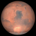
[[File:Mars globe.png |left|thumb|px| Eastern hemisphere of Mars Syrtis Major is the dark spot in the middle. Hellas Planitia lies to the south of Syrtis Major and appears light-toned due to clouds. Southern ice cap is at the bottom.]] | [[File:Mars globe.png |left|thumb|px| Eastern hemisphere of Mars Syrtis Major is the dark spot in the middle. Hellas Planitia lies to the south of Syrtis Major and appears light-toned due to clouds. Southern ice cap is at the bottom.]] | ||
| − | The HiRISE instrument onboard the Mars Reconnaissance Orbiter has discovered a strange feature on the floor of Hellas Planitia. Called "Honeycomb Terrain," it may be caused by great masses of buried water ice moving upward. <ref>Bernhardt, H.; et al. (2016). "The honeycomb terrain on the Hellas basin floor, mars: a case for salt or ice diapirism: hellas honeycombs as salt/ice diapirs". J. Geophys. Res. 121: 714–738.</ref> <ref>Weiss, D., J. Head. 2017. HYDROLOGY OF THE HELLAS BASIN AND THE EARLY MARS CLIMATE: WAS THE HONEYCOMB TERRAIN FORMED BY SALT OR ICE DIAPIRISM? Lunar and Planetary Science XLVIII. 1060.pdf</ref> <ref>Weiss, D.; Head, J. (2017). "Salt or ice diapirism origin for the honeycomb terrain in Hellas basin, Mars?: Implications for the early martian climate". Icarus. 284: 249–263.</ref> | + | |
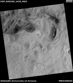
| + | The HiRISE instrument onboard the Mars Reconnaissance Orbiter has discovered a strange feature on the floor of Hellas Planitia. Called "Honeycomb Terrain," it may be caused by great masses of buried water ice moving upward. <ref>Bernhardt, H.; et al. (2016). "The honeycomb terrain on the Hellas basin floor, mars: a case for salt or ice diapirism: hellas honeycombs as salt/ice diapirs". J. Geophys. Res. 121: 714–738.</ref> <ref>Weiss, D., J. Head. 2017. HYDROLOGY OF THE HELLAS BASIN AND THE EARLY MARS CLIMATE: WAS THE HONEYCOMB TERRAIN FORMED BY SALT OR ICE DIAPIRISM? Lunar and Planetary Science XLVIII. 1060.pdf</ref> <ref>Weiss, D.; Head, J. (2017). "Salt or ice diapirism origin for the honeycomb terrain in Hellas basin, Mars?: Implications for the early martian climate". Icarus. 284: 249–263.</ref> However, there are several other hypothesizes for its creation being considered. | ||
[[File: ESP_049330_1425honeycomb.jpg|thumb|px|right|Honeycomb terrain on floor of Hellas Planitia that may be caused by masses of underground ice pushing up.]] | [[File: ESP_049330_1425honeycomb.jpg|thumb|px|right|Honeycomb terrain on floor of Hellas Planitia that may be caused by masses of underground ice pushing up.]] | ||
| − | There is a big contrast between the Western and Eastern hemisphere of Mars. The Western hemisphere has the great [[ Valles Marineris]], the Grand Canyon of Mars. It could stretch nearly across the continental United States. At its western end is a large group of intersecting canyons, called [[Noctis Labyrinthus]]. This hemisphere also hosts a region known as [[Tharsis]]. Tharsis is home to the largest volcanoes on Mars and in the solar system. The southern part contains Argyre Planitia, a large impact basin that probably contained a lake.<ref>Parker, T.; et al. 2000. Argyre Planitia and the Mars global hydrological cycle . LPSC. XXXI: 2033.</ref> <ref>Dohm, J.; Hare, T.; Robbins, S.; Williams, J.-P.; Soare, R.; El-Maarry, M.; Conway, S.; Buczkowski, D.; Kargel, J.; Banks, M.; Fairén, A.; Schulze-Makuch, D.; Komatsu, G.; Miyamoto, H.; Anderson, R.; Davila, A.; Mahaney, W.; Fink, W.; Cleaves, H.; Yan, J.; Hynek, B.; Maruyama, S. 201). Geological and hydrological histories of the Argyre province, Mars. Icarus. 253: 66–98.</ref> The western hemisphere also contains many outflow channels, such as [[Ares Vallis]], Ravi Vallis, Mawrth Vallis, and Kasei Valles in which giant flows of water went roaring though.<ref>Baker, V. 1982. The Channels of Mars. Austin: Texas University Press.</ref> <ref> Carr,M.H. (1979). "Formation of Martian flood features by release of water from confined aquifers". J. Geophys. Res., 84, 2995-3007.</ref> Calculations indicate that the amount of water required to erode such channels at least | + | There is a big contrast between the Western and Eastern hemisphere of Mars. The Western hemisphere has the great [[Valles Marineris]], the Grand Canyon of Mars. It could stretch nearly across the continental United States. At its western end is a large group of intersecting canyons, called [[Noctis Labyrinthus]]. This hemisphere also hosts a region known as [[Tharsis]]. Tharsis is home to the largest volcanoes on Mars and in the solar system. The southern part contains Argyre Planitia, a large impact basin that probably contained a lake.<ref>Parker, T.; et al. 2000. Argyre Planitia and the Mars global hydrological cycle . LPSC. XXXI: 2033.</ref> <ref>Dohm, J.; Hare, T.; Robbins, S.; Williams, J.-P.; Soare, R.; El-Maarry, M.; Conway, S.; Buczkowski, D.; Kargel, J.; Banks, M.; Fairén, A.; Schulze-Makuch, D.; Komatsu, G.; Miyamoto, H.; Anderson, R.; Davila, A.; Mahaney, W.; Fink, W.; Cleaves, H.; Yan, J.; Hynek, B.; Maruyama, S. 201). Geological and hydrological histories of the Argyre province, Mars. Icarus. 253: 66–98.</ref> The western hemisphere also contains many outflow channels, such as [[Ares Vallis]], Ravi Vallis, Mawrth Vallis, and Kasei Valles in which giant flows of water went roaring though.<ref>Baker, V. 1982. The Channels of Mars. Austin: Texas University Press.</ref> <ref>Carr,M.H. (1979). "Formation of Martian flood features by release of water from confined aquifers". J. Geophys. Res., 84, 2995-3007.</ref> Calculations indicate that the amount of water required to erode such channels at least equals and most probably exceeds by several orders of magnitude the present discharges of the largest terrestrial rivers. These Martian floods would be comparable to the largest floods known to have ever occurred on Earth (the ones that cut the Channeled Scablands in North America).<ref>Williams, R., Phillips, R., and Malin, M. 2000. Flow rates and duration within Kasei Vallis, Mars: Implications for the formation of a Martian ocean. Geophys. Res. Lett., 27, 1073-6.</ref> <ref>Robinson, M., and Takana, K. 1990. Magnitude of a catastrophic flood event in Kasei Vallis, Mars. Geology, 18, 902-5.</ref> |
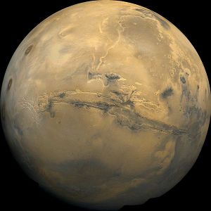
[[File:Mars Valles Marineris.jpg |left|thumb|px| Western hemisphere of Mars Valles Marineris dominates the picture. Long channel running to the North is large outflow channel called Kasei Valles. Three volcanoes are at the left edge.]] | [[File:Mars Valles Marineris.jpg |left|thumb|px| Western hemisphere of Mars Valles Marineris dominates the picture. Long channel running to the North is large outflow channel called Kasei Valles. Three volcanoes are at the left edge.]] | ||
| Line 30: | Line 42: | ||
==Craters== | ==Craters== | ||
| + | |||
[[File:Mars MGS colorhillshade mola 1024craters2.jpg|left|thumb|px|Map showing names and locations of quadrangles of Mars ]] | [[File:Mars MGS colorhillshade mola 1024craters2.jpg|left|thumb|px|Map showing names and locations of quadrangles of Mars ]] | ||
Because the surface of Mars is so old, billions of years in some areas, it contains many impact craters. Basically, the more craters the older the surface. The older, southern highlands contain far more craters than the North. Craters can help us sample material under the surface because an impact event brings material from deep underground. Moreover, some material from the impactor could be gathered by automated machines in the future for use by the colonists. Our rovers have already photographed and examined meteorites sitting on Mars. Meteoritic material is more likely to come from small craters, as in large impacts the impacting body is usually vaporized. | Because the surface of Mars is so old, billions of years in some areas, it contains many impact craters. Basically, the more craters the older the surface. The older, southern highlands contain far more craters than the North. Craters can help us sample material under the surface because an impact event brings material from deep underground. Moreover, some material from the impactor could be gathered by automated machines in the future for use by the colonists. Our rovers have already photographed and examined meteorites sitting on Mars. Meteoritic material is more likely to come from small craters, as in large impacts the impacting body is usually vaporized. | ||
| + | |||
[[Image: Meteoritemars.jpg |thumb|200px|left|Meteorite found on Mars by Opportunity Rover in the Margaritifer Sinus quadrangle]] | [[Image: Meteoritemars.jpg |thumb|200px|left|Meteorite found on Mars by Opportunity Rover in the Margaritifer Sinus quadrangle]] | ||
| Line 37: | Line 51: | ||
Many craters are believed to have once held lakes, including Argyre Planitia and Hellas Planitia in the South.<ref>Cabrol, N. and E. Grin (eds.). 2010. Lakes on Mars. Elsevier. NY.</ref> <ref>Voelker, M., et al. 2016. DISTRIBUTION AND EVOLUTION OF LACUSTRINE AND FLUVIAL FEATURES IN HELLAS PLANITIA, MARS, BASED ON PRELIMINARY RESULTS OF GRID-MAPPING. 47th Lunar and Planetary Science Conference (2016) 1228.pdf.</ref> <ref>arker, T.; et al. (2000). "Argyre Planitia and the Mars global hydrological cycle". LPSC. XXXI: 2033.</ref> | Many craters are believed to have once held lakes, including Argyre Planitia and Hellas Planitia in the South.<ref>Cabrol, N. and E. Grin (eds.). 2010. Lakes on Mars. Elsevier. NY.</ref> <ref>Voelker, M., et al. 2016. DISTRIBUTION AND EVOLUTION OF LACUSTRINE AND FLUVIAL FEATURES IN HELLAS PLANITIA, MARS, BASED ON PRELIMINARY RESULTS OF GRID-MAPPING. 47th Lunar and Planetary Science Conference (2016) 1228.pdf.</ref> <ref>arker, T.; et al. (2000). "Argyre Planitia and the Mars global hydrological cycle". LPSC. XXXI: 2033.</ref> | ||
High resolution views of many crater show that they have almost completely filled with ice which is visible as many concentric ridges. Craters begin with a bowl shape. After millions of years of collecting snow, they appear flat and shallow. Researchers have named the material “ Concentric Crater Fill .” | High resolution views of many crater show that they have almost completely filled with ice which is visible as many concentric ridges. Craters begin with a bowl shape. After millions of years of collecting snow, they appear flat and shallow. Researchers have named the material “ Concentric Crater Fill .” | ||
| + | |||
[[File:1024px-46622 1365contextccf.jpg |thumb|200px|left|Concentric Crater Fill Many craters show these concentric ridges which are from ice moving in the crater which has almost completely filled with ice.]] | [[File:1024px-46622 1365contextccf.jpg |thumb|200px|left|Concentric Crater Fill Many craters show these concentric ridges which are from ice moving in the crater which has almost completely filled with ice.]] | ||
The craters Milankovic, Lomonosov, Kunowsky, Lyot, and Mie are in the North and are easy to spot because there are very few features near them. The Viking 2 spacecraft landed near Mie Crater. Mariner Crater was discovered and named after the Mariner 4 spacecraft. Mariner 4’s image of Mariner Crater was the best picture returned by the Mariner 4 flyby. Nicholson and Schiaparelli Craters sit almost directly on the equator. | The craters Milankovic, Lomonosov, Kunowsky, Lyot, and Mie are in the North and are easy to spot because there are very few features near them. The Viking 2 spacecraft landed near Mie Crater. Mariner Crater was discovered and named after the Mariner 4 spacecraft. Mariner 4’s image of Mariner Crater was the best picture returned by the Mariner 4 flyby. Nicholson and Schiaparelli Craters sit almost directly on the equator. | ||
| + | |||
==South Pole Region== | ==South Pole Region== | ||
| + | |||
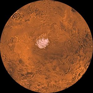
[[File:PIA00190-MC-30-MareAustraleRegion-19980605.jpg |right|thumb|px| Region of South Pole with ice cap Southern ice cap is much smaller than the North’s.]] | [[File:PIA00190-MC-30-MareAustraleRegion-19980605.jpg |right|thumb|px| Region of South Pole with ice cap Southern ice cap is much smaller than the North’s.]] | ||
| + | |||
This region is covered in the Mare Australe quadrangle. The ice cap at the South Pole is much smaller than the one in the North. | This region is covered in the Mare Australe quadrangle. The ice cap at the South Pole is much smaller than the one in the North. | ||
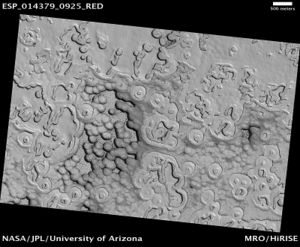
| − | Parts of Mare Australe display pits that make the surface look like Swiss cheese.<ref>Thomas,P., M. Malin, P. James, B. Cantor, R. Williams, P. GieraschSouth polar residual cap of Mars: features, stratigraphy, and changesIcarus, 174 (2 SPEC. ISS.). 2005. pp. 535–559. http://doi.org/10.1016/j.icarus.2004.07.028</ref> <ref>Thomas, P., P. James, W. Calvin, R. Haberle, M. Malin. 2009. Residual south polar cap of Mars: stratigraphy, history, and implications of recent changes Icarus: 203, 352–375 http://doi.org/10.1016/j.icarus.2009.05.014</ref> <ref>Thomas, P., W.Calvin, P. Gierasch, R. Haberle, P. James, S. Sholes. 2013. Time scales of erosion and deposition recorded in the residual south polar cap of mars Icarus: 225: 923–932 http://doi.org/10.1016/j.icarus.2012.08.038</ref> <ref>Thomas, P., W. Calvin, B. Cantor, R. Haberle, P. James, S. Lee. 2016. Mass balance of Mars’ residual south polar cap from CTX images and other data Icarus: 268, 118–130 http://doi.org/10.1016/j.icarus.2015.12.038</ref> These pits are in a 1-10 meter thick layer of dry ice that is sitting on a much larger water ice cap | + | Parts of Mare Australe display pits that make the surface look like Swiss cheese.<ref>Thomas,P., M. Malin, P. James, B. Cantor, R. Williams, P. GieraschSouth polar residual cap of Mars: features, stratigraphy, and changesIcarus, 174 (2 SPEC. ISS.). 2005. pp. 535–559. http://doi.org/10.1016/j.icarus.2004.07.028</ref> <ref>Thomas, P., P. James, W. Calvin, R. Haberle, M. Malin. 2009. Residual south polar cap of Mars: stratigraphy, history, and implications of recent changes Icarus: 203, 352–375 http://doi.org/10.1016/j.icarus.2009.05.014</ref> <ref>Thomas, P., W.Calvin, P. Gierasch, R. Haberle, P. James, S. Sholes. 2013. Time scales of erosion and deposition recorded in the residual south polar cap of mars Icarus: 225: 923–932 http://doi.org/10.1016/j.icarus.2012.08.038</ref> <ref>Thomas, P., W. Calvin, B. Cantor, R. Haberle, P. James, S. Lee. 2016. Mass balance of Mars’ residual south polar cap from CTX images and other data Icarus: 268, 118–130 http://doi.org/10.1016/j.icarus.2015.12.038</ref> These pits are in a 1-10 meter thick layer of dry ice that is sitting on a much larger water ice cap<ref>Buhler, Peter, Andrew Ingersoll, Bethany Ehlmann, Caleb Fassett, James Head. 2017. How the martian residual south polar cap develops quasi-circular and heart-shaped pits, troughs, and moats. Icarus: 286, 69-9.</ref>. Some, such as [[Robert Zubrin]] have suggested craters on the south pole of mars, specifically [[Korolev|Korolev Crater]] as promising site for a [[sublake settlement]] on mars<ref>https://www.centauri-dreams.org/2020/05/29/sublake-settlements-for-mars/</ref>. |
| + | |||
[[File:South Pole Terrain.jpg |center|thumb|px| Swiss cheese terrain, as seen by HiRISE]] | [[File:South Pole Terrain.jpg |center|thumb|px| Swiss cheese terrain, as seen by HiRISE]] | ||
| + | |||
==North Pole Region== | ==North Pole Region== | ||
| + | |||
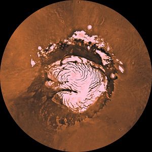
[[File:Mars NPArea-PIA00161.jpg |left|thumb|px| Spiral troughs in the northern ice cap]] | [[File:Mars NPArea-PIA00161.jpg |left|thumb|px| Spiral troughs in the northern ice cap]] | ||
| − | The ice cap in the north is far larger than the one in the south. It contains a large pattern of spiral-shaped troughs. In the troughs many layers are visible in high resolution photos. The layers | + | |
| − | From observations with the Shallow Radar instrument (SHARAD), researchers determined that the total volume of water ice in the cap is 821,000 cubic kilometers. That is equal to 30% of the Earth's Greenland ice sheet, or enough to cover the surface of Mars to a depth of 5.6 meters<ref> http://www.spaceref.com/news/viewpr.html?pid=29211 </ref> <ref> http://spaceref.com/onorbit/radar-map-of-buried-mars-layers-matches-climate-cycles.html</ref> <ref> https://mars.nasa.gov/news/371/radar-map-of-mars-layers-matches-climate-cycles/</ref> | + | The ice cap in the north is far larger than the one in the south. It contains a large pattern of spiral-shaped troughs. In the troughs many layers are visible in high resolution photos. The layers result from climate changes. At times the atmosphere contains more dust, consequently darker layers are formed. Sometimes thicker deposits of ice are deposited, making thicker layers. |
| + | From observations with the Shallow Radar instrument (SHARAD), researchers determined that the total volume of water ice in the cap is 821,000 cubic kilometers. That is equal to 30% of the Earth's Greenland ice sheet, or enough to cover the surface of Mars to a depth of 5.6 meters<ref>http://www.spaceref.com/news/viewpr.html?pid=29211 </ref> <ref>http://spaceref.com/onorbit/radar-map-of-buried-mars-layers-matches-climate-cycles.html</ref> <ref>https://mars.nasa.gov/news/371/radar-map-of-mars-layers-matches-climate-cycles/</ref> | ||
| + | |||
==Origin of Names== | ==Origin of Names== | ||
| + | |||
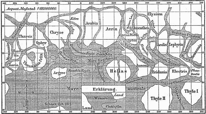
Many of the names for features on Mars are based on old classical names. Most of these names came from the names given by the astronomer G. V.Schiaparelli. A more detailed discussion of the origin of Martian nomenclature can be found in [[How are features on Mars Named?]]. | Many of the names for features on Mars are based on old classical names. Most of these names came from the names given by the astronomer G. V.Schiaparelli. A more detailed discussion of the origin of Martian nomenclature can be found in [[How are features on Mars Named?]]. | ||
| − | [[File:Karte Mars Schiaparelli MKL1888.png | | + | [[File:Karte Mars Schiaparelli MKL1888.png |600pxr|Early Schiaparelli map of Mars with many of the names we use today]] |
| − | [[File:Mars Viking MDIM21 ClrMosaic global 1024labeled5.jpg| | + | |
| + | [[File:Mars Viking MDIM21 ClrMosaic global 1024labeled5.jpg|600pxr| Image of Mars with most major features labeled This map can be freely used because it is in the public domain]] | ||
| + | |||
==Quadrangles== | ==Quadrangles== | ||
| − | |||
| − | |||
| + | One way of locating places on Mars is with [[Mars Quadrangles|quadrangles]]. The surface of Mars is divided into 30 areas. Each quadrangle has a number and a name. Detailed descriptions and many images from each quadrangle can be found on the [[Mars atlas Quadrangles|Quadrangles page]]<nowiki/>s. | ||
| − | [[File:MGS MOC Wide Angle Map of Mars PIA03467.jpg| | + | [[File:Marspediaquadrangleoutline.jpg|600pxr|Map showing names and locations of quadrangles]] |
| + | |||
| + | |||
| + | [[File:MGS MOC Wide Angle Map of Mars PIA03467.jpg|600pxr|Map of major lakes on Mars]] | ||
| + | |||
| + | Picture of Mars with quadrangles indicated. Pictures are from Mariner 9 and Viking orbiter images | ||
| + | |||
| + | ==Lakes on Mars== | ||
| + | |||
| + | [[File:Societytalksmarswith200.jpg|600pxr|Map of major lakes on Mars]] | ||
==Mission Landing Sites== | ==Mission Landing Sites== | ||
| + | |||
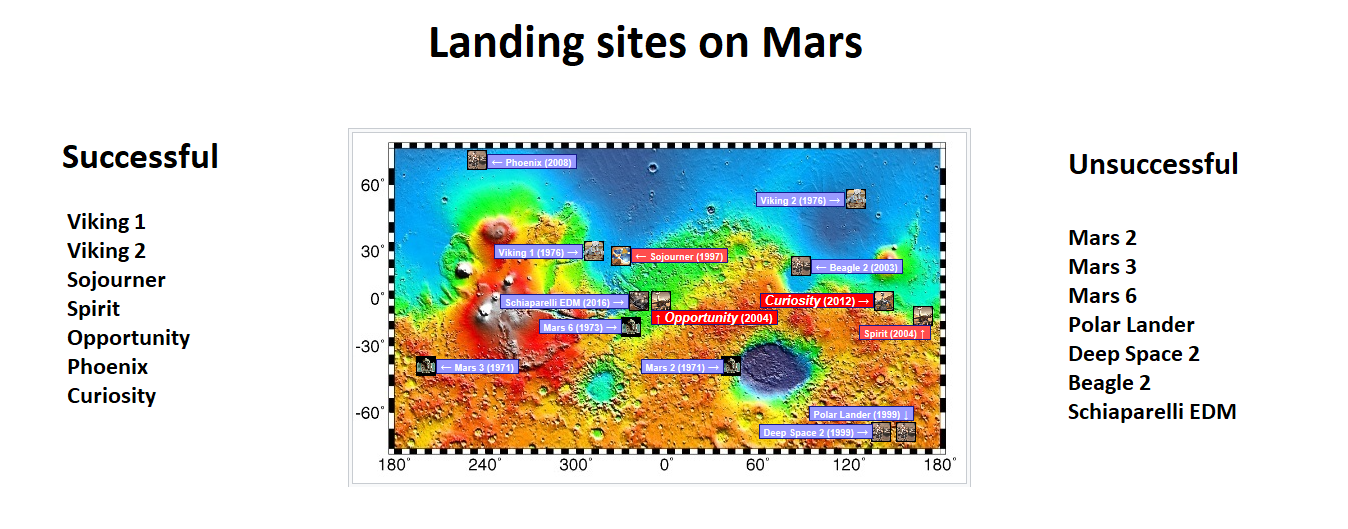
We have attempted to land on the Martian surface many times. There have been many failures. However, in recent years there have been some missions that have been highly successful. The Spirit and Opportunity Rovers were only expected to last for 3 months. Both lasted for many years. As of this writing (April 2018) Opportunity is still examining the planet. These twin rovers landed in January of 2004. It might go much longer, but the government is eager to shut them down. Curiosity Rover has sent back some great pictures and science. Some believe it will be working until people land on the planet. | We have attempted to land on the Martian surface many times. There have been many failures. However, in recent years there have been some missions that have been highly successful. The Spirit and Opportunity Rovers were only expected to last for 3 months. Both lasted for many years. As of this writing (April 2018) Opportunity is still examining the planet. These twin rovers landed in January of 2004. It might go much longer, but the government is eager to shut them down. Curiosity Rover has sent back some great pictures and science. Some believe it will be working until people land on the planet. | ||
The following map shows the landing sites and the dates of successful and unsuccessful missions. | The following map shows the landing sites and the dates of successful and unsuccessful missions. | ||
| − | [[File:Marspedialanders.png | | + | [[File:Marspedialanders.png |Landing sites and the dates of successful and unsuccessful missions]] |
| + | |||
| + | ==Locations of Clay and hydrated minerals== | ||
| + | |||
| + | |||
| + | |||
| + | [[File:Claymap.jpg|600pxr|Locations of clay and hydrated minerals]] | ||
| + | |||
| + | Locations of clay and hydrated minerals | ||
| + | |||
| + | |||
| + | |||
| + | ==Locations of ice== | ||
| + | |||
| + | [[File:Icemaplargelabeled454arrows.jpg|600pxr|Locations of near surface Ice]] | ||
| + | |||
| + | Locations of near surface Ice<ref>Sylvain Piqueux, Jennifer Buz, Christopher S. Edwards, Joshua L. Bandfield, Armin Kleinböhl, David M. Kass, Paul O. Hayne. Widespread Shallow Water Ice on Mars at High and Mid Latitudes. Geophysical Research Letters, 2019; DOI: 10.1029/2019GL083947 </ref> | ||
| + | |||
| + | |||
| + | Data gathered from spacecraft over many years has enable scientists to construct a map showing where ice may be found under a thin cover of sand. Places where ice is found under perhaps just centimeters of sand would be idea for future colonists. They could send robotic machines to gather ice which could provide water for settlements. Places where water-ice is found under a thin soli cover can be determined because of the properties of ice. If ice abundant ice is found just under the surface, the region will take longer to heat up in the spring and longer to cool down in the fall. Thermal inertia measurements gathered with the Mars Global Surveyor were used to generate a map of underground ice.<ref>https://www.hou.usra.edu/meetings/ninthmars2019/pdf/6027.pdf</ref> <ref>Piqeux, S. et al. 2019. WIDESPREAD SHALLOW WATER ICE ON MARS AT HIGH AND MID LATITUDES. Ninth International Conference on Mars 2019 (LPI Contrib. No. 2089). 6027.pdf.</ref> | ||
| + | |||
| + | A later study used two heat-sensitive instruments: MRO's Mars Climate Sounder and the Thermal Emission Imaging System (THEMIS) camera on Mars Odyssey to produce similar results to those using thermal inertia measurements from the Mars Global Surveyor. | ||
| + | <ref>https://phys.org/news/2019-12-nasa-treasure-ice-mars.html</ref> <ref>https://www.jpl.nasa.gov/news/news.php?feature=7557&utm_source=iContact&utm_medium=email&utm_campaign=nasajpl&utm_content=daily-20191210-2</ref> | ||
| + | |||
| + | [[File:Waterismeniuszoom.jpg|600pxr|Locations of ice]] | ||
| + | Locations of ice | ||
| + | |||
| + | ==Map of locations in Gale Crater== | ||
| + | |||
| + | [[File:Curiositymap.jpg|600pxr|Locations in Gale Crater]] | ||
| + | |||
| + | This map shows all the quadrant themes for NASA’s Curiosity Mars rover, which is currently in the Roraima quadrant seen at the bottom. The red oval indicates the landing ellipse where the rover was targeted to touch down in 2012. | ||
| + | |||
==References:== | ==References:== | ||
{{Reflist|2}} | {{Reflist|2}} | ||
| + | |||
==Further reading== | ==Further reading== | ||
| − | * Baker, V.R. (1982). The Channels of Mars. Austin: Texas University Press. | + | |
| − | * Carr,M.H. (1979). "Formation of Martian flood features by release of water from confined aquifers". J. Geophys. Res., 84, 2995-3007. | + | *Baker, V.R. (1982). The Channels of Mars. Austin: Texas University Press. |
| + | *Carr,M.H. (1979). "Formation of Martian flood features by release of water from confined aquifers". J. Geophys. Res., 84, 2995-3007. | ||
*Carr, M.H. (2006), The Surface of Mars. Cambridge Planetary Science Series, Cambridge University Press. | *Carr, M.H. (2006), The Surface of Mars. Cambridge Planetary Science Series, Cambridge University Press. | ||
*Robinson, M.S., and Takana, K.L. (1990), "Magnitude of a catastrophic flood event in Kasei Vallis, Mars". Geology, 18, 902-5. | *Robinson, M.S., and Takana, K.L. (1990), "Magnitude of a catastrophic flood event in Kasei Vallis, Mars". Geology, 18, 902-5. | ||
==See Also== | ==See Also== | ||
| + | |||
| + | *[[Aeolis quadrangle]] | ||
*[[Cebrenia quadrangle]] | *[[Cebrenia quadrangle]] | ||
| − | |||
*[[Diacria quadrangle]] | *[[Diacria quadrangle]] | ||
| − | |||
*[[Hellas Planitia]] | *[[Hellas Planitia]] | ||
*[[High Resolution Imaging Science Experiment (HiRISE)]] | *[[High Resolution Imaging Science Experiment (HiRISE)]] | ||
| Line 93: | Line 162: | ||
==External links== | ==External links== | ||
| − | |||
| − | * [https://www.youtube.com/watch?v=RYG-HLr33CM | + | *[https://planetarynames.wr.usgs.gov/Page/MARS/target Go here for information on names and locations on Mars] |
| + | |||
| + | *[https://en.wikipedia.org/wiki/Classical_albedo_features_on_Mars Classical_albedo_features_on_Mars]] | ||
| + | |||
| + | *[https://www.youtube.com/watch?v=JgMXPXdqJn8&t=389s Cosmic Journeys - Mars: Earth that Never Was] | ||
| + | |||
| + | *[https://en.wikipedia.org/wiki/Volcanology_of_Mars Volcanology of Mars] | ||
| + | |||
| + | *[https://www.youtube.com/watch?v=RYG-HLr33CM Martian Geology - Jim Secosky - 16th Annual International Mars Society Convention] | ||
| + | |||
| + | *[https://www.youtube.com/watch?v=_sUUKcZaTgA Jim Secosky - Martian Ice - 16th Annual International Mars Society Convention] | ||
| + | |||
| + | * [https://www.youtube.com/watch?v=D-SCOHj8u-A Water on Mars - James Secosky - 2021 Mars Society Virtual Convention -- Tells where water was and where ice is today on Mars (34 minutes)] | ||
| + | |||
| + | *https://www.hou.usra.edu/meetings/lpsc2022/pdf/1928.pdf Map of gullies on Mars | ||
| + | |||
| + | *https://www.hou.usra.edu/meetings/lpsc2022/pdf/1151.pdf Map of fans and deltas | ||
| + | *https://www.hou.usra.edu/meetings/lpsc2022/pdf/2669.pdf Map of subsurface ice | ||
[[Category:Areography]] | [[Category:Areography]] | ||
Latest revision as of 06:06, 9 October 2023
Article written by Jim Secosky. Jim is a retired science teacher who has used the Hubble Space Telescope, the Mars Global Surveyor, and HiRISE.
This article will describe the geography of Mars, starting with large features and then get more specific. Many maps will display groups of features and all can be copied and used without permission. Although there are many good maps of Martian features, most are under some sort of copyright protection.
Contents
- 1 Zero Longitude
- 2 North and South
- 3 East and West
- 4 Volcanoes
- 5 Craters
- 6 South Pole Region
- 7 North Pole Region
- 8 Origin of Names
- 9 Quadrangles
- 10 Lakes on Mars
- 11 Mission Landing Sites
- 12 Locations of Clay and hydrated minerals
- 13 Locations of ice
- 14 Map of locations in Gale Crater
- 15 References:
- 16 Further reading
- 17 See Also
- 18 External links
Zero Longitude
Zero longitude was first decided to be a crater called Airy Crater. Since we have higher resolution pictures and better understanding of the Martian surface this smaller crater that sits inside of Airy is our new zero longitude.[1]
North and South
One of the most significant aspects of Mars is the vast difference between the northern and southern hemispheres. Much of the north is smooth and of low elevation. In contrast, the southern half of the planet is rough with great numbers of craters (indicating an old age). The south is also much higher in altitude (between 1-3 km higher). The boundary between the Southern and the Northern hemispheres is called the Martian dichotomy. Although several ideas have been advanced to explain these differences, at present it is thought the northern hemisphere was struck on a low angle by an asteroid early in its history.[2] [3] [4]
East and West
The Eastern hemisphere of Mars holds a small collection of volcanoes, Hellas Planitia, (a large impact crater) and a dark area that was the first feature noted on the surface by early astronomers. Studies suggest that the heat from the impact that created the Hellas Basin caused the entire surface of Mars to heat hundreds of degrees. In addition, the surface was covered with 70 meters of molted rock which fell from the sky. For a time an atmosphere of gaseous rock existed. This rock atmosphere would have been 10 times as thick as the Earth's atmosphere. In a few days, the rock would have condensed out and covered the whole planet with an additional 10 m of molten rock.[5]
The HiRISE instrument onboard the Mars Reconnaissance Orbiter has discovered a strange feature on the floor of Hellas Planitia. Called "Honeycomb Terrain," it may be caused by great masses of buried water ice moving upward. [6] [7] [8] However, there are several other hypothesizes for its creation being considered.
There is a big contrast between the Western and Eastern hemisphere of Mars. The Western hemisphere has the great Valles Marineris, the Grand Canyon of Mars. It could stretch nearly across the continental United States. At its western end is a large group of intersecting canyons, called Noctis Labyrinthus. This hemisphere also hosts a region known as Tharsis. Tharsis is home to the largest volcanoes on Mars and in the solar system. The southern part contains Argyre Planitia, a large impact basin that probably contained a lake.[9] [10] The western hemisphere also contains many outflow channels, such as Ares Vallis, Ravi Vallis, Mawrth Vallis, and Kasei Valles in which giant flows of water went roaring though.[11] [12] Calculations indicate that the amount of water required to erode such channels at least equals and most probably exceeds by several orders of magnitude the present discharges of the largest terrestrial rivers. These Martian floods would be comparable to the largest floods known to have ever occurred on Earth (the ones that cut the Channeled Scablands in North America).[13] [14]
Volcanoes
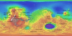
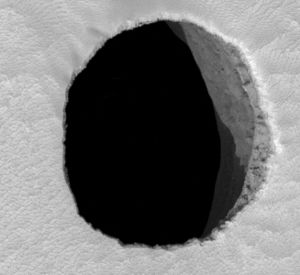
Mars is a land of great volcanoes. Tharsis contains the largest volcano in the solar system, along with several that are about as tall as the Earth’s tallest mountains. In addition, many small ones may actually be mostly covered by ash. We may be seeing only their tips.[15] Tharsis covers almost 25 % of the surface of the planet.[16] Elysium volcanic province, another smaller group of volcanoes, sits in the Eastern hemisphere; the biggest of the three is called Elysium Mons. Apollinaris Mons is near the landing site for the Spirit Rover. This volcano may have covered over expected lake deposits in Gusev Crater. The first feature to be drawn on early maps of Mars was Syrtis Major. This dark feature is volcanic by nature with two caldera: Meroe Patera and Nili Patera. Studies involving the regional gravity field suggest a solidified magma chamber exists beneath its surface.[17] Syrtis Major is of interest to geologists because dacite and granite have been detected there from orbiting spacecraft. Dacites and granites are very common on Earth but rare on Mars. Lava sometimes forms lava tunnels. These are places in which a hard cap forms on top of a flow while the rest of the liquid lava has moved away. These tunnels can be quite large. Many have suggested that future colonists can use these tunnels for their shelters where there would be protection from radiation and meteorites, and where there would be a more constant temperature. Some pictures taken with HiRISE seem to show pits that may lead into these hollowed out places.
Several old, eroded volcanoes exist near to the great impact crater Hellas Planitia. Some researchers have suggested that the location of the highland paterae around Hellas is due to deep-seated fractures caused by the impact that provided channels for magma to rise to the surface.[18] [19] [20]
Craters
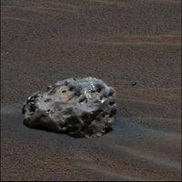
Because the surface of Mars is so old, billions of years in some areas, it contains many impact craters. Basically, the more craters the older the surface. The older, southern highlands contain far more craters than the North. Craters can help us sample material under the surface because an impact event brings material from deep underground. Moreover, some material from the impactor could be gathered by automated machines in the future for use by the colonists. Our rovers have already photographed and examined meteorites sitting on Mars. Meteoritic material is more likely to come from small craters, as in large impacts the impacting body is usually vaporized.
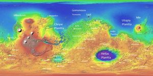
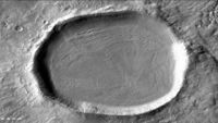
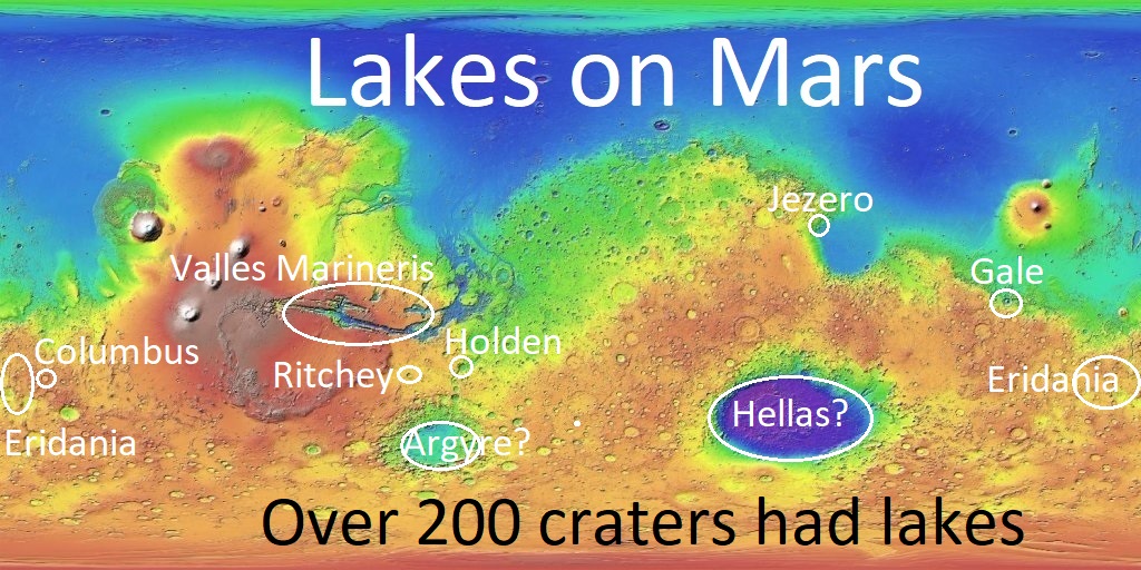
Low plains on Mars are called “Planitia.” Many of these were formed by impact events, especially Chryse, Utopia, Isidis, Argyre, and Hellas. Hellas Planitia is the deepest area on the planet. Many craters are believed to have once held lakes, including Argyre Planitia and Hellas Planitia in the South.[21] [22] [23] High resolution views of many crater show that they have almost completely filled with ice which is visible as many concentric ridges. Craters begin with a bowl shape. After millions of years of collecting snow, they appear flat and shallow. Researchers have named the material “ Concentric Crater Fill .”
The craters Milankovic, Lomonosov, Kunowsky, Lyot, and Mie are in the North and are easy to spot because there are very few features near them. The Viking 2 spacecraft landed near Mie Crater. Mariner Crater was discovered and named after the Mariner 4 spacecraft. Mariner 4’s image of Mariner Crater was the best picture returned by the Mariner 4 flyby. Nicholson and Schiaparelli Craters sit almost directly on the equator.
South Pole Region
This region is covered in the Mare Australe quadrangle. The ice cap at the South Pole is much smaller than the one in the North. Parts of Mare Australe display pits that make the surface look like Swiss cheese.[24] [25] [26] [27] These pits are in a 1-10 meter thick layer of dry ice that is sitting on a much larger water ice cap[28]. Some, such as Robert Zubrin have suggested craters on the south pole of mars, specifically Korolev Crater as promising site for a sublake settlement on mars[29].
North Pole Region
The ice cap in the north is far larger than the one in the south. It contains a large pattern of spiral-shaped troughs. In the troughs many layers are visible in high resolution photos. The layers result from climate changes. At times the atmosphere contains more dust, consequently darker layers are formed. Sometimes thicker deposits of ice are deposited, making thicker layers. From observations with the Shallow Radar instrument (SHARAD), researchers determined that the total volume of water ice in the cap is 821,000 cubic kilometers. That is equal to 30% of the Earth's Greenland ice sheet, or enough to cover the surface of Mars to a depth of 5.6 meters[30] [31] [32]
Origin of Names
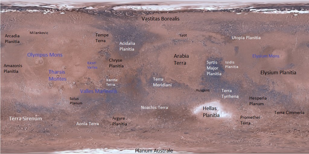
Many of the names for features on Mars are based on old classical names. Most of these names came from the names given by the astronomer G. V.Schiaparelli. A more detailed discussion of the origin of Martian nomenclature can be found in How are features on Mars Named?.
Quadrangles
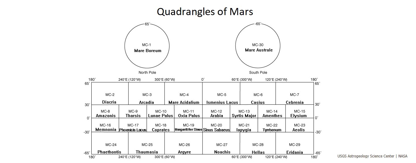
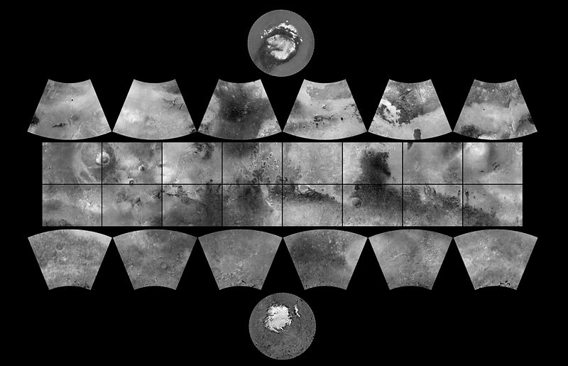
One way of locating places on Mars is with quadrangles. The surface of Mars is divided into 30 areas. Each quadrangle has a number and a name. Detailed descriptions and many images from each quadrangle can be found on the Quadrangles pages.
Picture of Mars with quadrangles indicated. Pictures are from Mariner 9 and Viking orbiter images
Lakes on Mars
Mission Landing Sites
We have attempted to land on the Martian surface many times. There have been many failures. However, in recent years there have been some missions that have been highly successful. The Spirit and Opportunity Rovers were only expected to last for 3 months. Both lasted for many years. As of this writing (April 2018) Opportunity is still examining the planet. These twin rovers landed in January of 2004. It might go much longer, but the government is eager to shut them down. Curiosity Rover has sent back some great pictures and science. Some believe it will be working until people land on the planet.
The following map shows the landing sites and the dates of successful and unsuccessful missions.
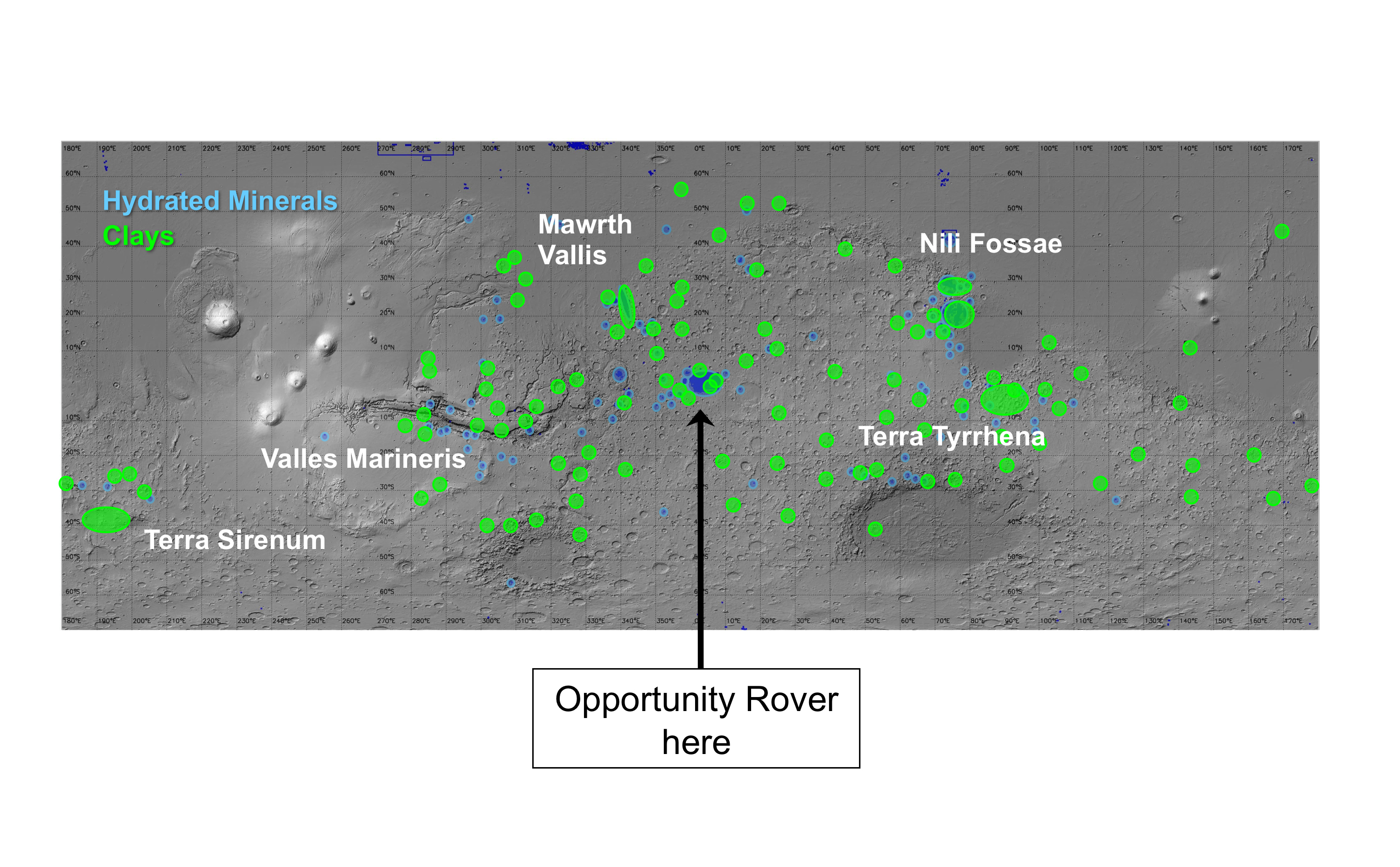
Locations of Clay and hydrated minerals
Locations of clay and hydrated minerals
Locations of ice
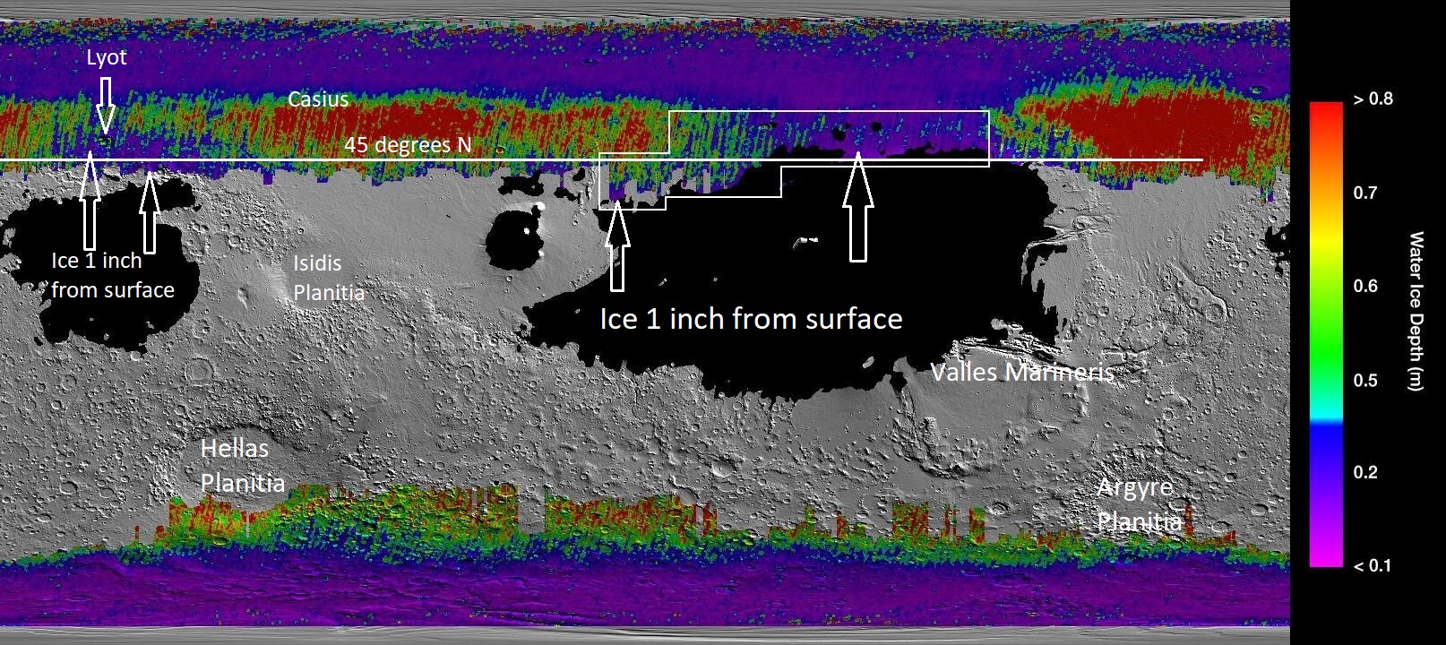
Locations of near surface Ice[33]
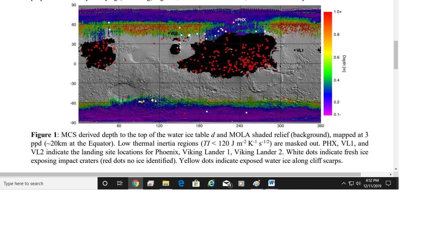
Data gathered from spacecraft over many years has enable scientists to construct a map showing where ice may be found under a thin cover of sand. Places where ice is found under perhaps just centimeters of sand would be idea for future colonists. They could send robotic machines to gather ice which could provide water for settlements. Places where water-ice is found under a thin soli cover can be determined because of the properties of ice. If ice abundant ice is found just under the surface, the region will take longer to heat up in the spring and longer to cool down in the fall. Thermal inertia measurements gathered with the Mars Global Surveyor were used to generate a map of underground ice.[34] [35]
A later study used two heat-sensitive instruments: MRO's Mars Climate Sounder and the Thermal Emission Imaging System (THEMIS) camera on Mars Odyssey to produce similar results to those using thermal inertia measurements from the Mars Global Surveyor. [36] [37]
Locations of ice
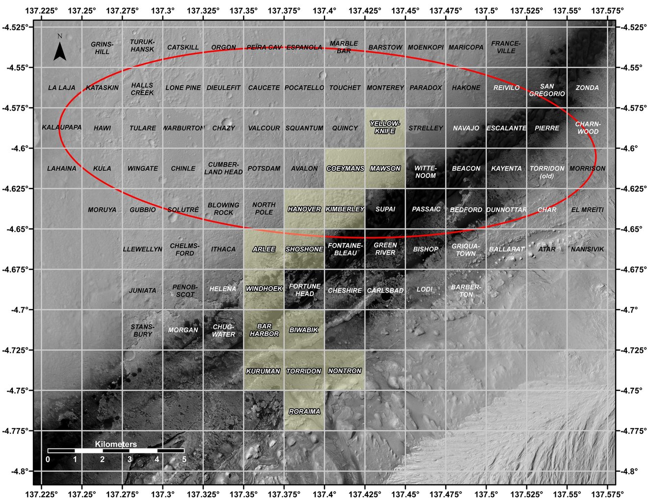
Map of locations in Gale Crater
This map shows all the quadrant themes for NASA’s Curiosity Mars rover, which is currently in the Roraima quadrant seen at the bottom. The red oval indicates the landing ellipse where the rover was targeted to touch down in 2012.
References:
- ↑ https://www.uahirise.org/ESP_071502_1750
- ↑ Andrews-Hanna; et al. (2008). "The Borealis basin and the origin of the Martian crustal dichotomy". Nature. 453 (7199): 1212–1215.
- ↑ Marinova; et al. (2008). "Mega-impact formation of the Mars hemispheric dichotomy". Nature. 453 (7199): 1216–1219.
- ↑ Nimmo; et al. (2008). "Implications of an impact origin for the Martian hemispheric dichotomy". Nature. 453 (7199): 1220–1223.
- ↑ Carr, Michael H. (2006). The Surface of Mars. Cambridge University Press. ISBN 978-0-521-87201-0.
- ↑ Bernhardt, H.; et al. (2016). "The honeycomb terrain on the Hellas basin floor, mars: a case for salt or ice diapirism: hellas honeycombs as salt/ice diapirs". J. Geophys. Res. 121: 714–738.
- ↑ Weiss, D., J. Head. 2017. HYDROLOGY OF THE HELLAS BASIN AND THE EARLY MARS CLIMATE: WAS THE HONEYCOMB TERRAIN FORMED BY SALT OR ICE DIAPIRISM? Lunar and Planetary Science XLVIII. 1060.pdf
- ↑ Weiss, D.; Head, J. (2017). "Salt or ice diapirism origin for the honeycomb terrain in Hellas basin, Mars?: Implications for the early martian climate". Icarus. 284: 249–263.
- ↑ Parker, T.; et al. 2000. Argyre Planitia and the Mars global hydrological cycle . LPSC. XXXI: 2033.
- ↑ Dohm, J.; Hare, T.; Robbins, S.; Williams, J.-P.; Soare, R.; El-Maarry, M.; Conway, S.; Buczkowski, D.; Kargel, J.; Banks, M.; Fairén, A.; Schulze-Makuch, D.; Komatsu, G.; Miyamoto, H.; Anderson, R.; Davila, A.; Mahaney, W.; Fink, W.; Cleaves, H.; Yan, J.; Hynek, B.; Maruyama, S. 201). Geological and hydrological histories of the Argyre province, Mars. Icarus. 253: 66–98.
- ↑ Baker, V. 1982. The Channels of Mars. Austin: Texas University Press.
- ↑ Carr,M.H. (1979). "Formation of Martian flood features by release of water from confined aquifers". J. Geophys. Res., 84, 2995-3007.
- ↑ Williams, R., Phillips, R., and Malin, M. 2000. Flow rates and duration within Kasei Vallis, Mars: Implications for the formation of a Martian ocean. Geophys. Res. Lett., 27, 1073-6.
- ↑ Robinson, M., and Takana, K. 1990. Magnitude of a catastrophic flood event in Kasei Vallis, Mars. Geology, 18, 902-5.
- ↑ Whitford-Stark, J. 1982. Tharsis Volcanoes: Separation Distances, Relative Ages, Sizes, Morphologies, and Depths of Burial. J. Geophys. Res. 87: 9829–9838.
- ↑ Solomon, Sean C.; Head, James W. (1982). "Evolution of the Tharsis Province of Mars: The Importance of Heterogeneous Lithospheric Thickness and Volcanic Construction". J. Geophys. Res. 87 (B12): 9755–9774.
- ↑ Kiefer, W. |year=2002 |title=Under the volcano: gravity evidence for an extinct magma chamber beneath Syrtis Major, Mars |work=American Geophysical Union, Fall Meeting 2002 |at=abstract #P71B-0463
- ↑ Peterson, J. 1978. Volcanism in the Noachis-Hellas region of Mars, 2. Lunar and Planetary Science. IX: 3411–3432.
- ↑ Williams, D.; et al. 2009. The Circum-Hellas volcanic province, Mars: Overview. Planetary and Space Science. 57: 895–916.
- ↑ Rodriguez, J.; K. Tanaka. 2006. Sisyphi Montes and southwest Hellas Paterae: possible impact, cryotectonic, volcanic, and mantle tectonic processes along Hellas Basin rings. Fourth Mars Polar Science Conference. p. 8066.
- ↑ Cabrol, N. and E. Grin (eds.). 2010. Lakes on Mars. Elsevier. NY.
- ↑ Voelker, M., et al. 2016. DISTRIBUTION AND EVOLUTION OF LACUSTRINE AND FLUVIAL FEATURES IN HELLAS PLANITIA, MARS, BASED ON PRELIMINARY RESULTS OF GRID-MAPPING. 47th Lunar and Planetary Science Conference (2016) 1228.pdf.
- ↑ arker, T.; et al. (2000). "Argyre Planitia and the Mars global hydrological cycle". LPSC. XXXI: 2033.
- ↑ Thomas,P., M. Malin, P. James, B. Cantor, R. Williams, P. GieraschSouth polar residual cap of Mars: features, stratigraphy, and changesIcarus, 174 (2 SPEC. ISS.). 2005. pp. 535–559. http://doi.org/10.1016/j.icarus.2004.07.028
- ↑ Thomas, P., P. James, W. Calvin, R. Haberle, M. Malin. 2009. Residual south polar cap of Mars: stratigraphy, history, and implications of recent changes Icarus: 203, 352–375 http://doi.org/10.1016/j.icarus.2009.05.014
- ↑ Thomas, P., W.Calvin, P. Gierasch, R. Haberle, P. James, S. Sholes. 2013. Time scales of erosion and deposition recorded in the residual south polar cap of mars Icarus: 225: 923–932 http://doi.org/10.1016/j.icarus.2012.08.038
- ↑ Thomas, P., W. Calvin, B. Cantor, R. Haberle, P. James, S. Lee. 2016. Mass balance of Mars’ residual south polar cap from CTX images and other data Icarus: 268, 118–130 http://doi.org/10.1016/j.icarus.2015.12.038
- ↑ Buhler, Peter, Andrew Ingersoll, Bethany Ehlmann, Caleb Fassett, James Head. 2017. How the martian residual south polar cap develops quasi-circular and heart-shaped pits, troughs, and moats. Icarus: 286, 69-9.
- ↑ https://www.centauri-dreams.org/2020/05/29/sublake-settlements-for-mars/
- ↑ http://www.spaceref.com/news/viewpr.html?pid=29211
- ↑ http://spaceref.com/onorbit/radar-map-of-buried-mars-layers-matches-climate-cycles.html
- ↑ https://mars.nasa.gov/news/371/radar-map-of-mars-layers-matches-climate-cycles/
- ↑ Sylvain Piqueux, Jennifer Buz, Christopher S. Edwards, Joshua L. Bandfield, Armin Kleinböhl, David M. Kass, Paul O. Hayne. Widespread Shallow Water Ice on Mars at High and Mid Latitudes. Geophysical Research Letters, 2019; DOI: 10.1029/2019GL083947
- ↑ https://www.hou.usra.edu/meetings/ninthmars2019/pdf/6027.pdf
- ↑ Piqeux, S. et al. 2019. WIDESPREAD SHALLOW WATER ICE ON MARS AT HIGH AND MID LATITUDES. Ninth International Conference on Mars 2019 (LPI Contrib. No. 2089). 6027.pdf.
- ↑ https://phys.org/news/2019-12-nasa-treasure-ice-mars.html
- ↑ https://www.jpl.nasa.gov/news/news.php?feature=7557&utm_source=iContact&utm_medium=email&utm_campaign=nasajpl&utm_content=daily-20191210-2
Further reading
- Baker, V.R. (1982). The Channels of Mars. Austin: Texas University Press.
- Carr,M.H. (1979). "Formation of Martian flood features by release of water from confined aquifers". J. Geophys. Res., 84, 2995-3007.
- Carr, M.H. (2006), The Surface of Mars. Cambridge Planetary Science Series, Cambridge University Press.
- Robinson, M.S., and Takana, K.L. (1990), "Magnitude of a catastrophic flood event in Kasei Vallis, Mars". Geology, 18, 902-5.
See Also
- Diacria quadrangle
- Hellas Planitia
- High Resolution Imaging Science Experiment (HiRISE)
- How are features on Mars Named?
- How living on Mars will be different than living on Earth
- Lunae Palus quadrangle
- Oxia Palus quadrangle
- Tharsis
- Valles Marineris
External links
- https://www.hou.usra.edu/meetings/lpsc2022/pdf/1928.pdf Map of gullies on Mars
- https://www.hou.usra.edu/meetings/lpsc2022/pdf/1151.pdf Map of fans and deltas
- https://www.hou.usra.edu/meetings/lpsc2022/pdf/2669.pdf Map of subsurface ice

